TopoQuest Logo
Do you find TopoQuest useful?
Help keep TopoQuest running and adding new maps/features by donating!
Bitcoin:  19c7KJd3qBynnjoSw5npx9KScwjBe4ifkT
Litecoin:  LXs6TkuXGGXo1vDsWCkWVdjQX94eUKd6ui
Home View Maps Find Maps Find Places Resources & Links


Dolan Springs, Texas Topographic Map

USGS Map Title: Dolan Springs, TX
USGS Map MRC: 29100H8
DRG (GeoTIFF) Download: o29100h8.tif


Neighboring USGS Topographic Map Quads:


  Deaton Draw, TX  
30101A1
 

  White Draw, TX  
30100A8
 

  Robinson Draw, TX  
30100A7
 

  Telephone Canyon, TX  
29101H1
 

  Dolan Springs, TX  
29100H8
 

  Open Hollow, TX  
29100H7
 

  Lechuguilla Creek, TX  
29101G1
 

  Clark Waterhole, TX  
29100G8
 

  Carruthers Draw, TX  
29100G7


Map MRC Location:

N30°
W101°
N30°
W100°
H8 H7 H6 H5 H4 H3 H2 H1
G8 G7 G6 G5 G4 G3 G2 G1
F8 F7 F6 F5 F4 F3 F2 F1
E8 E7 E6 E5 E4 E3 E2 E1
D8 D7 D6 D5 D4 D3 D2 D1
C8 C7 C6 C5 C4 C3 C2 C1
B8 B7 B6 B5 B4 B3 B2 B1
A8 A7 A6 A5 A4 A3 A2 A1
N29°
W101°
N29°
W100°

Dolan Springs, TX USGS 1:24K Topographic Map Preview:
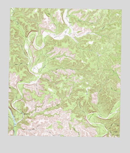
Dolan Springs, TX USGS Topographic Map
Click on map above to begin viewing in our Map Viewer.

This topographic map contains these locations and features:
Feature Name Type Latitude Longitude GNIS ID View Map
Blue SpringSpringN29.8939°W100.9945°1330919View Map
Bucktrap WellWellN29.9944°W100.9543°1331523View Map
Burnt Spot DrawValleyN29.9524°W100.9775°1331711View Map
Button Willow DrawValleyN29.9426°W100.9767°1331762View Map
Camp SpringSpringN29.8872°W100.8759°1332002View Map
Camp Spring CanyonValleyN29.8823°W100.8895°1332003View Map
Deep HollowValleyN29.9955°W100.9961°1334197View Map
Del Rio Northeast DivisionCivilN29.8835°W100.9088°1938678View Map
Devils River State Natural AreaParkN29.9355°W100.9434°2028494View Map
Dolan CreekStreamN29.8858°W100.9929°1334462View Map
Dolan FallsFallsN29.8846°W100.9937°1373421View Map
Dolan SpringsSpringN29.8972°W100.9840°1334463View Map
East CanyonValleyN29.9353°W100.9671°1334892View Map
Escondido CanyonValleyN29.9315°W100.9667°1335498View Map
Falls CanyonValleyN29.8820°W100.9943°1335682View Map
Horseshoe BendBendN29.8974°W100.9070°1338120View Map
Horseshoe Bend CanyonValleyN29.8966°W100.9129°1338123View Map
Indian CanyonValleyN29.9768°W100.9300°1338398View Map
Jack CreekStreamN29.9097°W100.9909°1338550View Map
Jane HollowValleyN29.8980°W100.8992°1338635View Map
Jesus CanyonValleyN29.9746°W100.9328°1338724View Map
Jose Maria SpringSpringN29.9286°W100.9879°1338880View Map
Leon SpringSpringN29.8813°W100.9729°1339821View Map
Leon Spring CanyonValleyN29.8832°W100.9906°1339822View Map
Live Oak CanyonValleyN29.8955°W100.9831°1340234View Map
Live Oak DrawValleyN29.9886°W100.9988°1340251View Map
RNK Ranch AirportAirportN29.9203°W100.9126°1386537View Map
Roberts HollowValleyN29.9934°W100.9325°1345316View Map
Rough Spring CanyonValleyN29.8963°W100.9803°1345654View Map
Snake SpringsSpringN29.8963°W100.9812°1347329View Map
Speed CanyonValleyN29.9477°W100.9593°1347637View Map
Spotted Oak CanyonValleyN29.8811°W100.8888°1347674View Map
Spotted Oak SpringSpringN29.8775°W100.8782°1347675View Map
Tom and Henry CanyonValleyN29.9009°W100.8792°1348622View Map
Turkey Track CanyonValleyN29.9271°W100.9703°1348893View Map
West Dolan CreekStreamN29.9674°W100.9818°1349698View Map
Yellow BluffCliffN29.8960°W100.9826°1350669View Map

Note: Coordinates in the location and feature list above are referenced to NAD83 datum.


Copyright (C) 2008-2025 Ryan Niemi / Sunset Dynamics ... All Rights Reserved