TopoQuest Logo
Do you find TopoQuest useful?
Help keep TopoQuest running and adding new maps/features by donating!
Bitcoin:  19c7KJd3qBynnjoSw5npx9KScwjBe4ifkT
Litecoin:  LXs6TkuXGGXo1vDsWCkWVdjQX94eUKd6ui
Home View Maps Find Maps Find Places Resources & Links


Dolores East, Colorado Topographic Map

USGS Map Title: Dolores East, CO
USGS Map MRC: 37108D4
DRG (GeoTIFF) Download: o37108d4.tif


Neighboring USGS Topographic Map Quads:


  Trimble Point, CO  
37108E5
 

  Boggy Draw, CO  
37108E4
 

  Stoner, CO  
37108E3
 

  Dolores West, CO  
37108D5
 

  Dolores East, CO  
37108D4
 

  Millwood, CO  
37108D3
 

  Cortez, CO  
37108C5
 

  Point Lookout, CO  
37108C4
 

  Mancos, CO  
37108C3


Map MRC Location:

N38°
W109°
N38°
W108°
H8 H7 H6 H5 H4 H3 H2 H1
G8 G7 G6 G5 G4 G3 G2 G1
F8 F7 F6 F5 F4 F3 F2 F1
E8 E7 E6 E5 E4 E3 E2 E1
D8 D7 D6 D5 D4 D3 D2 D1
C8 C7 C6 C5 C4 C3 C2 C1
B8 B7 B6 B5 B4 B3 B2 B1
A8 A7 A6 A5 A4 A3 A2 A1
N37°
W109°
N37°
W108°

Dolores East, CO USGS 1:24K Topographic Map Preview:
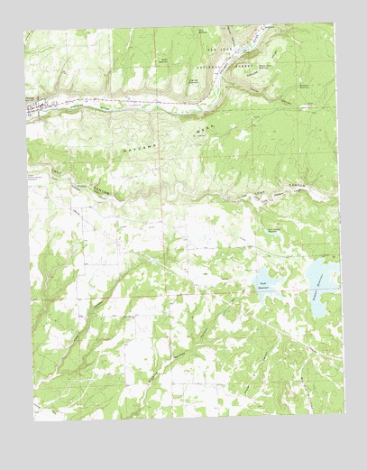
Dolores East, CO USGS Topographic Map
Click on map above to begin viewing in our Map Viewer.

This topographic map contains these locations and features:
Feature Name Type Latitude Longitude GNIS ID View Map
A M Puett DamDamN37.4183°W108.4123°200134View Map
Butler ReservoirReservoirN37.4892°W108.4423°178824View Map
Camp DitchCanalN37.4178°W108.4256°178815View Map
Carver CanyonValleyN37.4839°W108.4209°178818View Map
Cline ReservoirReservoirN37.4982°W108.4300°178825View Map
Dolores City ParkParkN37.4750°W108.4915°1794976View Map
Dolores Elementary SchoolSchoolN37.4764°W108.4948°1794978View Map
Dolores Fire Department Station 2BuildingN37.4350°W108.4371°2667161View Map
Dolores Forest Service FacilityLocaleN37.4772°W108.4770°197283View Map
Dolores High SchoolSchoolN37.4762°W108.4935°1794977View Map
Dolores Post OfficePost OfficeN37.4739°W108.4971°1794987View Map
East Lakeview SchoolSchoolN37.4078°W108.4584°178809View Map
Grimes DamDamN37.4250°W108.4540°201522View Map
Grimes ReservoirReservoirN37.4250°W108.4540°201523View Map
Grouse PointCliffN37.4861°W108.4034°178821View Map
Grouse ReservoirReservoirN37.4863°W108.4062°178822View Map
Italian CanyonValleyN37.4925°W108.4159°178826View Map
Lost Canyon DamDamN37.4347°W108.4056°200130View Map
Lost Canyon ReservoirReservoirN37.4330°W108.4020°178816View Map
Mulligan ReservoirReservoirN37.4805°W108.3901°178819View Map
Puett ReservoirReservoirN37.4169°W108.4058°176925View Map
South Main DitchCanalN37.4111°W108.4201°178813View Map
StapletonPopulated PlaceN37.4989°W108.4048°178823View Map
Summit DamDamN37.4225°W108.3881°200136View Map
Summit DitchCanalN37.4397°W108.4340°178817View Map
Summit ReservoirReservoirN37.4165°W108.3836°202609View Map
Town of DoloresCivilN37.4740°W108.4998°2412439View Map
United Methodist ChurchChurchN37.4755°W108.4995°1794979View Map
Van Pelt ReservoirReservoirN37.4826°W108.4303°178820View Map

Note: Coordinates in the location and feature list above are referenced to NAD83 datum.


Copyright (C) 2008-2025 Ryan Niemi / Sunset Dynamics ... All Rights Reserved