TopoQuest Logo
Do you find TopoQuest useful?
Help keep TopoQuest running and adding new maps/features by donating!
Bitcoin:  19c7KJd3qBynnjoSw5npx9KScwjBe4ifkT
Litecoin:  LXs6TkuXGGXo1vDsWCkWVdjQX94eUKd6ui
Home View Maps Find Maps Find Places Resources & Links


Dolores Point North, Colorado Topographic Map

USGS Map Title: Dolores Point North, CO
USGS Map MRC: 38109F1
DRG (GeoTIFF) Download: o38109f1.tif


Neighboring USGS Topographic Map Quads:


  Blue Chief Mesa, UT  
38109G2
 

  Steamboat Mesa, UT  
38109G1
 

  Two V Basin, CO  
38108G8
 

  Fisher Valley, UT  
38109F2
 

  Dolores Point North, CO  
38109F1
 

  Gateway, CO  
38108F8
 

  Mount Waas, UT  
38109E2
 

  Dolores Point South, CO  
38109E1
 

  Juanita Arch, CO  
38108E8


Map MRC Location:

N39°
W110°
N39°
W109°
H8 H7 H6 H5 H4 H3 H2 H1
G8 G7 G6 G5 G4 G3 G2 G1
F8 F7 F6 F5 F4 F3 F2 F1
E8 E7 E6 E5 E4 E3 E2 E1
D8 D7 D6 D5 D4 D3 D2 D1
C8 C7 C6 C5 C4 C3 C2 C1
B8 B7 B6 B5 B4 B3 B2 B1
A8 A7 A6 A5 A4 A3 A2 A1
N38°
W110°
N38°
W109°

Dolores Point North, CO USGS 1:24K Topographic Map Preview:
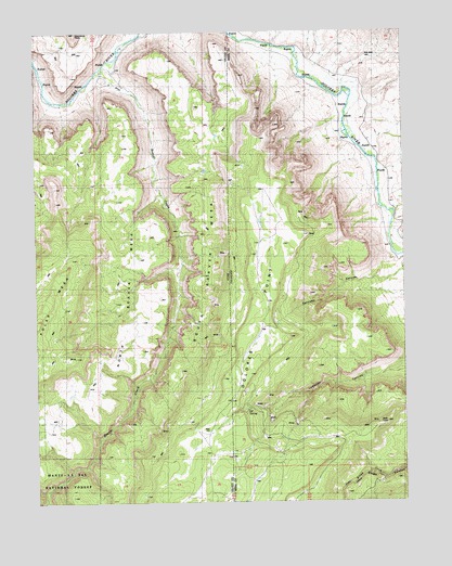
Dolores Point North, CO USGS Topographic Map
Click on map above to begin viewing in our Map Viewer.

This topographic map contains these locations and features:
Feature Name Type Latitude Longitude GNIS ID View Map
Ajax One MineMineN38.6717°W109.0259°1735621View Map
Austin MineMineN38.6480°W109.0251°1735712View Map
Beaver CreekStreamN38.7397°W109.1034°1438518View Map
Bonanza MineMineN38.6569°W109.0607°1735685View Map
Captain Jinks MineMineN38.7044°W109.0434°1735708View Map
Dolores PointSummitN38.6583°W109.0534°203047View Map
Dolores Point SpringSpringN38.6808°W109.0412°185166View Map
DP SpringSpringN38.6828°W109.0296°197240View Map
Gateway CanyonValleyN38.6843°W109.0039°185167View Map
Gilmore LodeMineN38.6433°W109.0426°1735616View Map
Hubbard MineMineN38.6542°W109.0471°1735716View Map
John Brown MineMineN38.6269°W109.0432°1735615View Map
Johnnie Mae MineMineN38.6405°W109.0418°1735614View Map
La Sal Group MineMineN38.6433°W109.0379°1735862View Map
La Salle Group MineMineN38.6433°W109.0379°1735617View Map
Lost Dutchman MineMineN38.6408°W109.0559°1735689View Map
Lost Indian MineMineN38.6480°W109.0251°1735711View Map
Lumsden MineMineN38.6461°W109.0457°1735690View Map
Mark MineMineN38.6269°W109.0421°1735691View Map
North Beaver Mesa MineMineN38.7014°W109.0334°1735713View Map
Pack Rat MineMineN38.6497°W109.0493°1735619View Map
Rae Marie MineMineN38.7489°W109.0582°1735620View Map
Shakin Quakie MineMineN38.6497°W109.0493°1735697View Map
Smith MineMineN38.7028°W109.0554°1735861View Map
South Beaver MesaSummitN38.6375°W109.1018°1445790View Map
Sunspot MineMineN38.7044°W109.0434°1735863View Map
Sunspot MineMineN38.7053°W109.0434°1735618View Map
Upper John Brown MineMineN38.6261°W109.0446°1735714View Map
Winfield-McCormick MineMineN38.7019°W109.0284°1735715View Map
Yellow Cat MineMineN38.7019°W109.0562°1735706View Map

Note: Coordinates in the location and feature list above are referenced to NAD83 datum.


Copyright (C) 2008-2024 Ryan Niemi / Sunset Dynamics ... All Rights Reserved