TopoQuest Logo
Do you find TopoQuest useful?
Help keep TopoQuest running and adding new maps/features by donating!
Bitcoin:  19c7KJd3qBynnjoSw5npx9KScwjBe4ifkT
Litecoin:  LXs6TkuXGGXo1vDsWCkWVdjQX94eUKd6ui
Home View Maps Find Maps Find Places Resources & Links


Dominek Lake, Montana Topographic Map

USGS Map Title: Dominek Lake, MT
USGS Map MRC: 48104F1
DRG (GeoTIFF) Download: o48104f1.tif


Neighboring USGS Topographic Map Quads:


  Tadpole Lake, MT  
48104G2
 

  Westby South, MT  
48104G1
 

  Alkabo, ND  
48103G8
 

  Coalridge, MT  
48104F2
 

  Dominek Lake, MT  
48104F1
 

  Camp Lake, ND  
48103F8
 

  Dagmar, MT  
48104E2
 

  Brush Lake, MT  
48104E1
 

  Grenora, ND  
48103E8


Map MRC Location:

N49°
W105°
N49°
W104°
H8 H7 H6 H5 H4 H3 H2 H1
G8 G7 G6 G5 G4 G3 G2 G1
F8 F7 F6 F5 F4 F3 F2 F1
E8 E7 E6 E5 E4 E3 E2 E1
D8 D7 D6 D5 D4 D3 D2 D1
C8 C7 C6 C5 C4 C3 C2 C1
B8 B7 B6 B5 B4 B3 B2 B1
A8 A7 A6 A5 A4 A3 A2 A1
N48°
W105°
N48°
W104°

Dominek Lake, MT USGS 1:24K Topographic Map Preview:
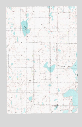
Dominek Lake, MT USGS Topographic Map
Click on map above to begin viewing in our Map Viewer.

This topographic map contains these locations and features:
Feature Name Type Latitude Longitude GNIS ID View Map
33N58E01ABAB01 WellWellN48.6495°W104.0663°1636121View Map
34N58E13AAAD01 WellWellN48.7061°W104.0485°1636252View Map
34N58E13AAAD02 WellWellN48.7061°W104.0485°1636253View Map
34N58E13BBDD01 WellWellN48.7047°W104.0741°1636248View Map
34N58E13CDBB01 WellWellN48.6975°W104.0741°1636232View Map
34N58E14AAAA01 WellWellN48.7075°W104.0797°1636265View Map
34N58E14ACAA01 WellWellN48.7039°W104.0838°1636247View Map
34N58E14BDDD01 WellWellN48.7014°W104.0899°1636242View Map
34N58E14CBDD01 WellWellN48.6972°W104.0947°1636231View Map
34N58E14DBDD01 WellWellN48.6975°W104.0838°1636233View Map
34N58E22AACC01 WellWellN48.6909°W104.1052°1636217View Map
34N58E23BBBB01 WellWellN48.6931°W104.0994°1636225View Map
34N58E26ADAB01 WellWellN48.6736°W104.0810°1636166View Map
35N58E36CBBB01 WellWellN48.7442°W104.0727°1636346View Map
Dominek LakeLakeN48.7258°W104.0918°799148View Map
Immanuel CemeteryCemeteryN48.6642°W104.0827°799143View Map
Monota Post Office (historical)Post OfficeN48.6284°W104.0641°1677565View Map
Whittier School (historical)SchoolN48.6278°W104.0891°1677521View Map

Note: Coordinates in the location and feature list above are referenced to NAD83 datum.


Copyright (C) 2008-2025 Ryan Niemi / Sunset Dynamics ... All Rights Reserved