TopoQuest Logo
Do you find TopoQuest useful?
Help keep TopoQuest running and adding new maps/features by donating!
Bitcoin:  19c7KJd3qBynnjoSw5npx9KScwjBe4ifkT
Litecoin:  LXs6TkuXGGXo1vDsWCkWVdjQX94eUKd6ui
Home View Maps Find Maps Find Places Resources & Links


Drake, South Carolina Topographic Map

USGS Map Title: Drake, SC
USGS Map MRC: 34079D6
DRG (GeoTIFF) Download: o34079d6.tif


Neighboring USGS Topographic Map Quads:


  Society Hill, SC  
34079E7
 

  Bennettsville South, SC  
34079E6
 

  Clio, SC  
34079E5
 

  Mont Clare, SC  
34079D7
 

  Drake, SC  
34079D6
 

  Bingham, SC  
34079D5
 

  Darlington East, SC  
34079C7
 

  Witherspoon Island, SC  
34079C6
 

  Oak Grove, SC  
34079C5


Map MRC Location:

N35°
W80°
N35°
W79°
H8 H7 H6 H5 H4 H3 H2 H1
G8 G7 G6 G5 G4 G3 G2 G1
F8 F7 F6 F5 F4 F3 F2 F1
E8 E7 E6 E5 E4 E3 E2 E1
D8 D7 D6 D5 D4 D3 D2 D1
C8 C7 C6 C5 C4 C3 C2 C1
B8 B7 B6 B5 B4 B3 B2 B1
A8 A7 A6 A5 A4 A3 A2 A1
N34°
W80°
N34°
W79°

Drake, SC USGS 1:24K Topographic Map Preview:
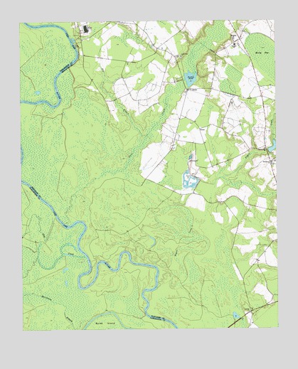
Drake, SC USGS Topographic Map
Click on map above to begin viewing in our Map Viewer.

This topographic map contains these locations and features:
Feature Name Type Latitude Longitude GNIS ID View Map
Antioch ChurchChurchN34.3821°W79.6387°1244903View Map
ArgylePopulated PlaceN34.4890°W79.6823°1232654View Map
Big BranchStreamN34.4532°W79.6881°1220677View Map
Blenheim DivisionCivilN34.4517°W79.6518°1938203View Map
Blenheim Fire Department DrakeBuildingN34.4723°W79.6661°2578558View Map
Blenheim SchoolSchoolN34.4902°W79.6445°1246917View Map
Brownsville CemeteryCemeteryN34.4418°W79.6267°1232679View Map
Brownsville ChurchChurchN34.4424°W79.6273°1247025View Map
Brownsville School (historical)SchoolN34.4424°W79.6270°1232681View Map
Cedar Falls ChurchChurchN34.4857°W79.6706°1247208View Map
Culps NeckCapeN34.3882°W79.7089°1240838View Map
Dailys PondReservoirN34.4782°W79.6578°1238521View Map
DrakePopulated PlaceN34.4727°W79.6670°1231237View Map
Drake School (historical)SchoolN34.4710°W79.6520°1232701View Map
Drakes MillpondReservoirN34.4767°W79.6663°1238493View Map
Drakes PondReservoirN34.4763°W79.6692°1222088View Map
Flat CreekStreamN34.4049°W79.7187°1222430View Map
GenoaPopulated PlaceN34.4563°W79.6620°1231310View Map
Hugh Driggers PondReservoirN34.4486°W79.6263°1238495View Map
Hunts BluffCliffN34.4849°W79.7206°1232735View Map
Hunts Bluff School (historical)SchoolN34.4840°W79.6976°1232736View Map
Hunts Bluff School (historical)SchoolN34.4879°W79.7192°1232737View Map
Key School (historical)SchoolN34.4410°W79.6270°1232742View Map
Mossy BaySwampN34.4844°W79.6286°1224674View Map
Muddy CreekStreamN34.4990°W79.7331°1224874View Map
ParnassusPopulated PlaceN34.4927°W79.6423°1232777View Map
Parnassus ChurchChurchN34.4929°W79.6448°1250027View Map
Parnassus GraveyardCemeteryN34.4927°W79.6456°1232778View Map
Parnassus School (historical)SchoolN34.4927°W79.6451°1232779View Map
Pleasant Hill ChurchChurchN34.4482°W79.6301°1250172View Map
Poston PondReservoirN34.4853°W79.6518°1238523View Map
Rogers CreekStreamN34.4013°W79.6862°1250460View Map
South Carolina Noname 35006 DamDamN34.4757°W79.6681°1238492View Map
South Carolina Noname 35007 D-3459 DamDamN34.4468°W79.6281°1238494View Map
South Carolina Noname 35030 D-3458 DamDamN34.4785°W79.6581°1238520View Map
South Carolina Noname 35034 D-2947 DamDamN34.4852°W79.6531°1238522View Map
Three CreeksStreamN34.4182°W79.7248°1251166View Map

Note: Coordinates in the location and feature list above are referenced to NAD83 datum.


Copyright (C) 2008-2025 Ryan Niemi / Sunset Dynamics ... All Rights Reserved