TopoQuest Logo
Do you find TopoQuest useful?
Help keep TopoQuest running and adding new maps/features by donating!
Bitcoin:  19c7KJd3qBynnjoSw5npx9KScwjBe4ifkT
Litecoin:  LXs6TkuXGGXo1vDsWCkWVdjQX94eUKd6ui
Home View Maps Find Maps Find Places Resources & Links


Duchesne, Utah Topographic Map

USGS Map Title: Duchesne, UT
USGS Map MRC: 40110B4
DRG (GeoTIFF) Download: o40110b4.tif


Neighboring USGS Topographic Map Quads:


  Blacktail Mountain, UT  
40110C5
 

  Talmage, UT  
40110C4
 

  Altamont, UT  
40110C3
 

  Rabbit Gulch, UT  
40110B5
 

  Duchesne, UT  
40110B4
 

  Duchesne NE, UT  
40110B3
 

  Buck Knoll, UT  
40110A5
 

  Duchesne SW, UT  
40110A4
 

  Duchesne SE, UT  
40110A3


Map MRC Location:

N41°
W111°
N41°
W110°
H8 H7 H6 H5 H4 H3 H2 H1
G8 G7 G6 G5 G4 G3 G2 G1
F8 F7 F6 F5 F4 F3 F2 F1
E8 E7 E6 E5 E4 E3 E2 E1
D8 D7 D6 D5 D4 D3 D2 D1
C8 C7 C6 C5 C4 C3 C2 C1
B8 B7 B6 B5 B4 B3 B2 B1
A8 A7 A6 A5 A4 A3 A2 A1
N40°
W111°
N40°
W110°

Duchesne, UT USGS 1:24K Topographic Map Preview:
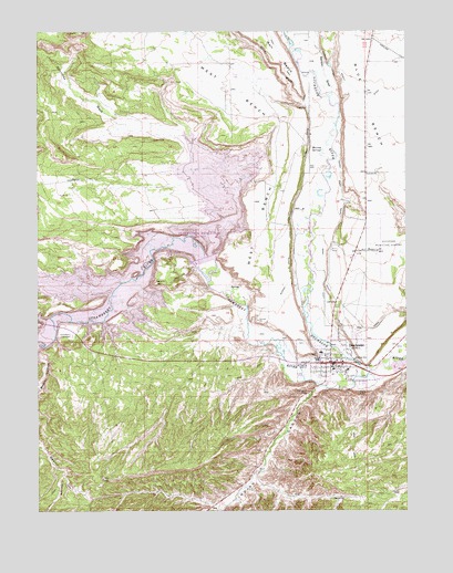
Duchesne, UT USGS Topographic Map
Click on map above to begin viewing in our Map Viewer.

This topographic map contains these locations and features:
Feature Name Type Latitude Longitude GNIS ID View Map
Benson CreekStreamN40.2311°W110.3985°1435118View Map
Benson DrawValleyN40.2313°W110.3996°1425435View Map
City CanalCanalN40.1877°W110.4038°1426648View Map
City of DuchesneCivilN40.1753°W110.3940°2410365View Map
DuchesnePopulated PlaceN40.1633°W110.4029°1427601View Map
Duchesne City CemeteryCemeteryN40.1550°W110.4090°1427602View Map
Duchesne County JailBuildingN40.1795°W110.3883°2769015View Map
Duchesne County Sheriff's OfficeBuildingN40.1793°W110.3882°2730337View Map
Duchesne Elementary SchoolSchoolN40.1662°W110.4043°1435462View Map
Duchesne Fire DepartmentBuildingN40.1627°W110.3999°2627116View Map
Duchesne High SchoolSchoolN40.1642°W110.4045°1435461View Map
Duchesne Municipal AirportAirportN40.1925°W110.3856°1434580View Map
Duchesne Post OfficePost OfficeN40.1637°W110.3970°2769052View Map
First Baptist ChurchChurchN40.1641°W110.4363°1436711View Map
Indian CanyonValleyN40.1572°W110.4049°1428988View Map
Murray SpringsSpringN40.2191°W110.4039°1430613View Map
Murray White CanalCanalN40.2105°W110.4121°1430614View Map
Pulley BendBendN40.1916°W110.4477°1431496View Map
Rabbit GulchValleyN40.1833°W110.4757°1431534View Map
Rocky Point CanalCanalN40.2075°W110.3974°1431972View Map
Saleratus WashValleyN40.1927°W110.4424°1432127View Map
Sand WashValleyN40.2277°W110.4024°1432220View Map
Starvation CampgroundLocaleN40.1897°W110.4535°1450517View Map
Starvation DamDamN40.1904°W110.4439°1434778View Map
Starvation ReservoirReservoirN40.1911°W110.4658°1434779View Map
Starvation State ParkParkN40.2027°W110.4471°1455534View Map
Strawberry CemeteryCemeteryN40.1705°W110.4888°1433007View Map
Strawberry RiverStreamN40.1616°W110.3885°1446192View Map
The Church of Jesus Christ of Latter Day SaintsChurchN40.1733°W110.3929°1436898View Map
The Church of Jesus Christ of Latter Day SaintsChurchN40.1616°W110.3957°1450729View Map
Theodore CemeteryCemeteryN40.1686°W110.4106°2769290View Map
United States Forest Service Fire Station - Office DuchesneBuildingN40.1602°W110.4078°2768495View Map
West BenchBenchN40.2305°W110.4252°1434048View Map

Note: Coordinates in the location and feature list above are referenced to NAD83 datum.


Copyright (C) 2008-2024 Ryan Niemi / Sunset Dynamics ... All Rights Reserved