TopoQuest Logo
Do you find TopoQuest useful?
Help keep TopoQuest running and adding new maps/features by donating!
Bitcoin:  19c7KJd3qBynnjoSw5npx9KScwjBe4ifkT
Litecoin:  LXs6TkuXGGXo1vDsWCkWVdjQX94eUKd6ui
Home View Maps Find Maps Find Places Resources & Links


Dulce, New Mexico Topographic Map

USGS Map Title: Dulce, NM
USGS Map MRC: 36106H8
DRG (GeoTIFF) Download: o36106h8.tif


Neighboring USGS Topographic Map Quads:


  Trujillo, CO  
37107A1
 

  Edith, CO  
37106A8
 

  Chromo, CO  
37106A7
 

  Wirt Canyon, NM  
36107H1
 

  Dulce, NM  
36106H8
 

  Monero, NM  
36106H7
 

  John Mills Lake, NM  
36107G1
 

  Cordova Canyon, NM  
36106G8
 

  Horse Lake, NM  
36106G7


Map MRC Location:

N37°
W107°
N37°
W106°
H8 H7 H6 H5 H4 H3 H2 H1
G8 G7 G6 G5 G4 G3 G2 G1
F8 F7 F6 F5 F4 F3 F2 F1
E8 E7 E6 E5 E4 E3 E2 E1
D8 D7 D6 D5 D4 D3 D2 D1
C8 C7 C6 C5 C4 C3 C2 C1
B8 B7 B6 B5 B4 B3 B2 B1
A8 A7 A6 A5 A4 A3 A2 A1
N36°
W107°
N36°
W106°

Dulce, NM USGS 1:24K Topographic Map Preview:
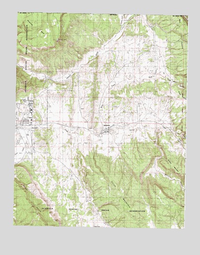
Dulce, NM USGS Topographic Map
Click on map above to begin viewing in our Map Viewer.

This topographic map contains these locations and features:
Feature Name Type Latitude Longitude GNIS ID View Map
AmargoPopulated PlaceN36.9378°W106.8917°898515View Map
Amargo Post Office (historical)Post OfficeN36.9378°W106.8917°937741View Map
Archuleta MesaSummitN36.9972°W106.9703°899508View Map
Atole PondLakeN36.8753°W106.9410°900041View Map
Belino-Peisker MineMineN36.9053°W106.9525°917087View Map
Caranta LeaseMineN36.9083°W106.9609°917057View Map
Cornell ProspectMineN36.9053°W106.9525°917061View Map
Coyote CreekStreamN36.9920°W106.9232°191035View Map
Cuesta MoneroRidgeN36.9250°W106.8817°900040View Map
DulcePopulated PlaceN36.9336°W106.9989°928722View Map
Dulce Airport (historical)AirportN36.9278°W106.9839°936943View Map
Dulce Assembly of God ChurchChurchN36.9336°W106.9989°920478View Map
Dulce Baptist Indian MissionChurchN36.9336°W106.9989°920491View Map
Dulce CanyonValleyN36.9256°W106.9911°888565View Map
Dulce Elementary SchoolSchoolN36.9336°W106.9989°914696View Map
Dulce Fire DepartmentBuildingN36.9342°W106.9924°2657738View Map
Dulce High SchoolSchoolN36.9336°W106.9989°914697View Map
Dulce Middle SchoolSchoolN36.9336°W106.9989°914698View Map
Dulce MountainSummitN36.8847°W106.9170°936869View Map
Dulce Post OfficePost OfficeN36.9336°W106.9989°937948View Map
Dulce Weather StationLocaleN36.9336°W106.9989°932407View Map
Indian SanitariumHospitalN36.9470°W106.9892°890315View Map
Jicarilla Apache Historic DistrictLocaleN36.9336°W106.9989°935221View Map
Jicarilla Apache Reformed ChurchChurchN36.9336°W106.9989°920466View Map
Jicarilla Apache Reservation Historical MarkerParkN36.9336°W106.9989°932802View Map
Jicarilla LibraryBuildingN36.9336°W106.9989°930505View Map
Jicarilla MuseumBuildingN36.9336°W106.9989°929493View Map
KCIE-FM (Dulce)TowerN36.9833°W106.9706°938644View Map
Lower Mundo DamDamN36.8750°W106.9273°923967View Map
LumbertonPopulated PlaceN36.9300°W106.9370°891491View Map
Lumberton Census Designated PlaceCensusN36.9328°W106.9354°2584148View Map
Lumberton Post OfficePost OfficeN36.9300°W106.9370°938507View Map
Lumberton ProspectMineN36.9195°W106.9539°917002View Map
Saint Francis Elementary SchoolSchoolN36.9300°W106.9370°934087View Map
Tafoya MineMineN36.9247°W106.8945°917069View Map
Tafoya ProspectMineN36.9311°W106.8936°917070View Map
Webb CanyonValleyN36.9625°W106.8848°896299View Map
Webb CreekStreamN36.9300°W106.9359°893976View Map

Note: Coordinates in the location and feature list above are referenced to NAD83 datum.


Copyright (C) 2008-2024 Ryan Niemi / Sunset Dynamics ... All Rights Reserved