TopoQuest Logo
Do you find TopoQuest useful?
Help keep TopoQuest running and adding new maps/features by donating!
Bitcoin:  19c7KJd3qBynnjoSw5npx9KScwjBe4ifkT
Litecoin:  LXs6TkuXGGXo1vDsWCkWVdjQX94eUKd6ui
Home View Maps Find Maps Find Places Resources & Links


Duncans Bridge, Missouri Topographic Map

USGS Map Title: Duncans Bridge, MO
USGS Map MRC: 39092E3
DRG (GeoTIFF) Download: o39092e3.tif


Neighboring USGS Topographic Map Quads:


  Macon, MO  
39092F4
 

  Clarence, MO  
39092F3
 

  Lentner, MO  
39092F2
 

  Jacksonville, MO  
39092E4
 

  Duncans Bridge, MO  
39092E3
 

  Woodlawn, MO  
39092E2
 

  Moberly, MO  
39092D4
 

  Middle Grove, MO  
39092D3
 

  Madison, MO  
39092D2


Map MRC Location:

N40°
W93°
N40°
W92°
H8 H7 H6 H5 H4 H3 H2 H1
G8 G7 G6 G5 G4 G3 G2 G1
F8 F7 F6 F5 F4 F3 F2 F1
E8 E7 E6 E5 E4 E3 E2 E1
D8 D7 D6 D5 D4 D3 D2 D1
C8 C7 C6 C5 C4 C3 C2 C1
B8 B7 B6 B5 B4 B3 B2 B1
A8 A7 A6 A5 A4 A3 A2 A1
N39°
W93°
N39°
W92°

Duncans Bridge, MO USGS 1:24K Topographic Map Preview:
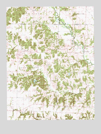
Duncans Bridge, MO USGS Topographic Map
Click on map above to begin viewing in our Map Viewer.

This topographic map contains these locations and features:
Feature Name Type Latitude Longitude GNIS ID View Map
AshPopulated PlaceN39.5150°W92.2899°740638View Map
Ash School (historical)SchoolN39.5150°W92.2752°743937View Map
Camp ThunderbirdLocaleN39.5423°W92.3293°715291View Map
Capp CemeteryCemeteryN39.5702°W92.2662°715384View Map
Capps School (historical)SchoolN39.5484°W92.2696°743938View Map
Dean CemeteryCemeteryN39.5943°W92.3009°716771View Map
Duncans BridgePopulated PlaceN39.5756°W92.2638°729304View Map
Felps ChapelChurchN39.5603°W92.3166°729310View Map
Felps School (historical)SchoolN39.5661°W92.3160°743940View Map
Hickory Grove ChurchChurchN39.5148°W92.2907°729321View Map
Hughes CemeteryCemeteryN39.5278°W92.2846°719971View Map
Levick MillPopulated PlaceN39.5761°W92.3466°741011View Map
Liberty School (historical)SchoolN39.6200°W92.2660°733582View Map
Matthews School (historical)SchoolN39.5106°W92.3610°743943View Map
Mayes Lake DamDamN39.5934°W92.2668°762277View Map
Mull Brothers LakeReservoirN39.5503°W92.2859°760382View Map
Mull Brothers Lake DamDamN39.5517°W92.2852°760381View Map
Northeast Randolph Rural Fire Association JacksonvilleBuildingN39.5735°W92.3574°2620707View Map
Phillips CemeteryCemeteryN39.5830°W92.2800°724292View Map
Pleasant View CemeteryCemeteryN39.5109°W92.3671°724640View Map
Rich Land CreekStreamN39.5975°W92.2835°725253View Map
Ridings School (historical)SchoolN39.5881°W92.3302°743939View Map
Salem ChurchChurchN39.5884°W92.3652°729387View Map
Thunderbird LakeReservoirN39.5431°W92.3350°761400View Map
Thunderbird Lake DamDamN39.5450°W92.3335°761399View Map
Township of Salt RiverCivilN39.5651°W92.3520°767263View Map
Turner School (historical)SchoolN39.5170°W92.3207°743942View Map
Waters School (historical)SchoolN39.5639°W92.3574°743941View Map
Wilkerson DamDamN39.5967°W92.2752°762276View Map
WoodvillePopulated PlaceN39.6203°W92.3363°735927View Map
Woodville School (historical)SchoolN39.6195°W92.3346°733742View Map

Note: Coordinates in the location and feature list above are referenced to NAD83 datum.


Copyright (C) 2008-2025 Ryan Niemi / Sunset Dynamics ... All Rights Reserved