TopoQuest Logo
Do you find TopoQuest useful?
Help keep TopoQuest running and adding new maps/features by donating!
Bitcoin:  19c7KJd3qBynnjoSw5npx9KScwjBe4ifkT
Litecoin:  LXs6TkuXGGXo1vDsWCkWVdjQX94eUKd6ui
Home View Maps Find Maps Find Places Resources & Links


Dunlap, Texas Topographic Map

USGS Map Title: Dunlap, TX
USGS Map MRC: 34100B3
DRG (GeoTIFF) Download: o34100b3.tif


Neighboring USGS Topographic Map Quads:


  Tell South, TX  
34100C4
 

  Hell Roaring Creek, TX  
34100C3
 

  Buckle L Ranch, TX  
34100C2
 

  Cee Vee, TX  
34100B4
 

  Dunlap, TX  
34100B3
 

  Swearingen, TX  
34100B2
 

  Devils Canyon, TX  
34100A4
 

  Paducah, TX  
34100A3
 

  Moons Camp, TX  
34100A2


Map MRC Location:

N35°
W101°
N35°
W100°
H8 H7 H6 H5 H4 H3 H2 H1
G8 G7 G6 G5 G4 G3 G2 G1
F8 F7 F6 F5 F4 F3 F2 F1
E8 E7 E6 E5 E4 E3 E2 E1
D8 D7 D6 D5 D4 D3 D2 D1
C8 C7 C6 C5 C4 C3 C2 C1
B8 B7 B6 B5 B4 B3 B2 B1
A8 A7 A6 A5 A4 A3 A2 A1
N34°
W101°
N34°
W100°

Dunlap, TX USGS 1:24K Topographic Map Preview:
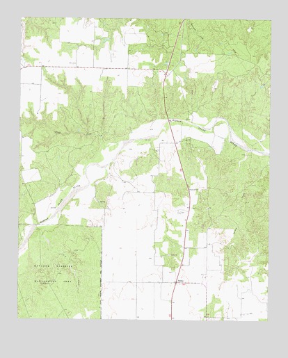
Dunlap, TX USGS Topographic Map
Click on map above to begin viewing in our Map Viewer.

This topographic map contains these locations and features:
Feature Name Type Latitude Longitude GNIS ID View Map
Bluff CreekStreamN34.1992°W100.3234°1352516View Map
DunlapPopulated PlaceN34.1406°W100.2965°1379686View Map
O X WindmillLocaleN34.1398°W100.3596°1364254View Map
Ox CreekStreamN34.1659°W100.3596°1375318View Map
Paducah North DivisionCivilN34.1696°W100.2922°1939067View Map
Turkey CreekStreamN34.1956°W100.2609°1370231View Map

Note: Coordinates in the location and feature list above are referenced to NAD83 datum.


Copyright (C) 2008-2025 Ryan Niemi / Sunset Dynamics ... All Rights Reserved