TopoQuest Logo
Do you find TopoQuest useful?
Help keep TopoQuest running and adding new maps/features by donating!
Bitcoin:  19c7KJd3qBynnjoSw5npx9KScwjBe4ifkT
Litecoin:  LXs6TkuXGGXo1vDsWCkWVdjQX94eUKd6ui
Home View Maps Find Maps Find Places Resources & Links


Dunn, North Carolina Topographic Map

USGS Map Title: Dunn, NC
USGS Map MRC: 35078C5
DRG (GeoTIFF) Download: o35078c5.tif


Neighboring USGS Topographic Map Quads:


  Coats, NC  
35078D6
 

  Benson, NC  
35078D5
 

  Four Oaks, NC  
35078D4
 

  Erwin, NC  
35078C6
 

  Dunn, NC  
35078C5
 

  Peacocks Crossroads, NC  
35078C4
 

  Wade, NC  
35078B6
 

  Mingo, NC  
35078B5
 

  Timothy, NC  
35078B4


Map MRC Location:

N36°
W79°
N36°
W78°
H8 H7 H6 H5 H4 H3 H2 H1
G8 G7 G6 G5 G4 G3 G2 G1
F8 F7 F6 F5 F4 F3 F2 F1
E8 E7 E6 E5 E4 E3 E2 E1
D8 D7 D6 D5 D4 D3 D2 D1
C8 C7 C6 C5 C4 C3 C2 C1
B8 B7 B6 B5 B4 B3 B2 B1
A8 A7 A6 A5 A4 A3 A2 A1
N35°
W79°
N35°
W78°

Dunn, NC USGS 1:24K Topographic Map Preview:
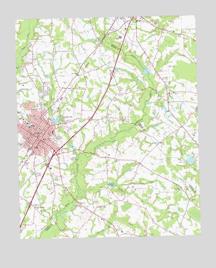
Dunn, NC USGS Topographic Map
Click on map above to begin viewing in our Map Viewer.

This topographic map contains these locations and features:
Feature Name Type Latitude Longitude GNIS ID View Map
Banner ChapelChurchN35.3702°W78.5278°980529View Map
Beulah ChurchChurchN35.3296°W78.5256°981267View Map
Big Juniper RunStreamN35.2735°W78.5845°981415View Map
Black River ChurchChurchN35.3007°W78.5947°981541View Map
City of DunnCivilN35.3112°W78.6129°2403518View Map
Crusader CampLocaleN35.2663°W78.6097°983811View Map
Devotional GardensCemeteryN35.3510°W78.6125°984157View Map
Divine Street United Methodist ChurchChurchN35.3088°W78.6153°1952471View Map
DunnPopulated PlaceN35.3063°W78.6089°1020051View Map
Dunn Emergency ServicesBuildingN35.3073°W78.6118°2639730View Map
Dunn Emergency Services Station 2BuildingN35.3094°W78.6086°2638202View Map
Dunn Middle SchoolSchoolN35.3146°W78.6150°1006645View Map
Dunn PlazaLocaleN35.2971°W78.5933°1007358View Map
Dunn Police DepartmentBuildingN35.3067°W78.6068°2769802View Map
Dunn Post OfficePost OfficeN35.2973°W78.6158°1952472View Map
Elmon BridgeBridgeN35.2721°W78.5861°1952519View Map
Fair Haven ChurchChurchN35.3393°W78.5236°984893View Map
First Baptist Church of DunnChurchN35.3096°W78.6133°1952508View Map
First Presbyterian ChurchChurchN35.3202°W78.6131°1952511View Map
Floral Gardens Shopping CenterLocaleN35.3168°W78.6233°1007359View Map
Godwins LakeReservoirN35.2952°W78.5264°998763View Map
Godwins Lake DamDamN35.2952°W78.5264°998762View Map
Greenwood CemeteryCemeteryN35.3040°W78.6225°986126View Map
Grove ParkPopulated PlaceN35.3121°W78.5900°1005024View Map
Grove Park Shopping CenterLocaleN35.3185°W78.5753°1007360View Map
Hannas LakeReservoirN35.3168°W78.5979°998790View Map
Hannas Lake DamDamN35.3168°W78.5981°998791View Map
Harnett Primary SchoolSchoolN35.3099°W78.6003°1006644View Map
Hayner PondReservoirN35.3438°W78.5347°998840View Map
Hayner Pond DamDamN35.3418°W78.5347°998841View Map
Heritage CollegeSchoolN35.2685°W78.6125°986638View Map
Hood Memorial Christian ChurchChurchN35.3060°W78.6092°1952513View Map
Jernigan PondReservoirN35.2801°W78.5606°987575View Map
Jonesboro ChurchChurchN35.3285°W78.5578°987767View Map
Lakeside VillagePopulated PlaceN35.3188°W78.5939°1021084View Map
Lees Grove ChurchChurchN35.3427°W78.6097°988317View Map
Leslie ChurchChurchN35.3438°W78.5786°988365View Map
Little Juniper RunStreamN35.2791°W78.5561°988688View Map
Long Branch ChurchChurchN35.2688°W78.6136°988934View Map
Mary Stewart SchoolSchoolN35.3427°W78.5822°989423View Map
McLambs PondReservoirN35.3024°W78.5871°998770View Map
McLambs Pond DamDamN35.3002°W78.5864°998771View Map
Mingo BridgeBridgeN35.2979°W78.5725°1952524View Map
Mingo Hill ChurchChurchN35.2696°W78.5825°990056View Map
Mingo Primitive ChurchChurchN35.2677°W78.5695°990057View Map
Mount Zion ChurchChurchN35.2702°W78.5056°990641View Map
National Estates Incorporated Airport (historical)AirportN35.2702°W78.5736°997903View Map
Neighbors Grove ChurchChurchN35.3552°W78.6017°990899View Map
North Clinton Avenue Baptist ChurchChurchN35.3113°W78.6053°1952514View Map
Oakland School (historical)SchoolN35.2810°W78.5478°1952525View Map
Resthaven Memorial ParkCemeteryN35.3068°W78.5997°993246View Map
Sacred Heart Catholic ChurchChurchN35.3107°W78.6156°1952515View Map
Savannah Hill ChurchChurchN35.2760°W78.5128°994384View Map
Stony RunStreamN35.2968°W78.5833°995584View Map
Stony Run ChurchChurchN35.2938°W78.5570°995585View Map
Township of AverasboroCivilN35.3173°W78.5974°1026761View Map
Tyler ParkParkN35.3143°W78.6178°996396View Map
Wayne Avenue SchoolSchoolN35.3160°W78.6178°996889View Map
Wayne Avenue Shopping CenterLocaleN35.3182°W78.6206°1007361View Map
WCKB-AM (Dunn)TowerN35.2918°W78.5956°1025086View Map
WesthavenPopulated PlaceN35.3235°W78.6128°1005023View Map
WPYB-AM (Benson)TowerN35.3613°W78.5789°1018437View Map
Young Lookout TowerTowerN35.3463°W78.5195°1023698View Map

Note: Coordinates in the location and feature list above are referenced to NAD83 datum.


Copyright (C) 2008-2025 Ryan Niemi / Sunset Dynamics ... All Rights Reserved