TopoQuest Logo
Do you find TopoQuest useful?
Help keep TopoQuest running and adding new maps/features by donating!
Bitcoin:  19c7KJd3qBynnjoSw5npx9KScwjBe4ifkT
Litecoin:  LXs6TkuXGGXo1vDsWCkWVdjQX94eUKd6ui
Home View Maps Find Maps Find Places Resources & Links


Durango East, Colorado Topographic Map

USGS Map Title: Durango East, CO
USGS Map MRC: 37107C7
DRG (GeoTIFF) Download: o37107c7.tif


Neighboring USGS Topographic Map Quads:


  Monument Hill, CO  
37107D8
 

  Hermosa, CO  
37107D7
 

  Lemon Reservoir, CO  
37107D6
 

  Durango West, CO  
37107C8
 

  Durango East, CO  
37107C7
 

  Rules Hill, CO  
37107C6
 

  Basin Mountain, CO  
37107B8
 

  Loma Linda, CO  
37107B7
 

  Gem Village, CO  
37107B6


Map MRC Location:

N38°
W108°
N38°
W107°
H8 H7 H6 H5 H4 H3 H2 H1
G8 G7 G6 G5 G4 G3 G2 G1
F8 F7 F6 F5 F4 F3 F2 F1
E8 E7 E6 E5 E4 E3 E2 E1
D8 D7 D6 D5 D4 D3 D2 D1
C8 C7 C6 C5 C4 C3 C2 C1
B8 B7 B6 B5 B4 B3 B2 B1
A8 A7 A6 A5 A4 A3 A2 A1
N37°
W108°
N37°
W107°

Durango East, CO USGS 1:24K Topographic Map Preview:
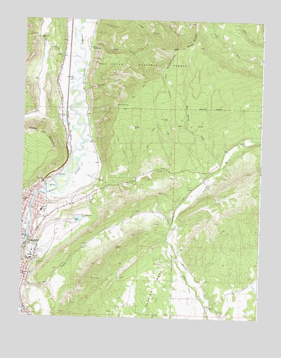
Durango East, CO USGS Topographic Map
Click on map above to begin viewing in our Map Viewer.

This topographic map contains these locations and features:
Feature Name Type Latitude Longitude GNIS ID View Map
Animas City CemeteryCemeteryN37.2908°W107.8586°184182View Map
Animas City MountainSummitN37.3275°W107.8698°184178View Map
Animas MuseumBuildingN37.2994°W107.8742°1795398View Map
Animas Ranger StationLocaleN37.3628°W107.8403°184181View Map
Baldy MountainSummitN37.3636°W107.7831°184177View Map
Bible Missionary ChurchChurchN37.2894°W107.8645°1795338View Map
Camp HallBuildingN37.2758°W107.8701°1795326View Map
Chapman Hill Municipal Ski AreaParkN37.2831°W107.8695°1795250View Map
Christ the King Lutheran ChurchChurchN37.2839°W107.8703°1795337View Map
City MineMineN37.2647°W107.8659°1734958View Map
City of DurangoCivilN37.2744°W107.8702°2410374View Map
Cornerstone Evangelical Free ChurchChurchN37.2992°W107.8737°1795333View Map
Crofton HallBuildingN37.2764°W107.8703°1795323View Map
Dan Noble HallBuildingN37.2764°W107.8670°1795318View Map
Durango Fire and Rescue Authority Station 13 - Falls Creek StationBuildingN37.3687°W107.8687°2667118View Map
Durango Fire and Rescue Authority Station 3BuildingN37.3003°W107.8482°2667114View Map
Durango Fire and Rescue Authority Station 5BuildingN37.3117°W107.7774°2667120View Map
Durango High SchoolSchoolN37.2886°W107.8733°1795328View Map
Durango Regulatory DamDamN37.2900°W107.8506°200088View Map
Durango Regulatory ReservoirReservoirN37.2900°W107.8506°200089View Map
Durango Urgent CareHospitalN37.2925°W107.8747°2695670View Map
Emerson-Parks BridgeBridgeN37.3003°W107.8692°1795335View Map
Falls CreekStreamN37.3539°W107.8481°183890View Map
Fanto ParkParkN37.2664°W107.8748°1795317View Map
Fifty-five Plus CenterBuildingN37.2897°W107.8748°1795331View Map
Fireglow MineMineN37.2997°W107.8040°1734962View Map
First United Methodist ChurchChurchN37.2953°W107.8620°1795344View Map
Florida CanalCanalN37.2542°W107.8028°202986View Map
Florida CemeteryCemeteryN37.2541°W107.7734°2780652View Map
Florida ChurchChurchN37.2542°W107.7737°184176View Map
Florida MesaSummitN37.2728°W107.8031°202984View Map
Folsom ParkParkN37.2881°W107.8690°1795347View Map
Fort Lewis CollegeSchoolN37.2754°W107.8670°184170View Map
Fort Lewis College Field HouseBuildingN37.2775°W107.8695°1795320View Map
Fort Lewis College NatoriumBuildingN37.2772°W107.8701°1795321View Map
Foursquare Gospel ChurchChurchN37.2931°W107.8631°1795342View Map
Haflin CanyonValleyN37.3650°W107.8388°184180View Map
Hesperus HallBuildingN37.2769°W107.8678°1795319View Map
Horse GulchValleyN37.2643°W107.8722°184168View Map
Huck Finn PondLakeN37.2808°W107.8743°184183View Map
Janson Memorial PlaygroundParkN37.2922°W107.8653°1795340View Map
John F Reed LibraryBuildingN37.2761°W107.8690°1794968View Map
Junction CreekStreamN37.2853°W107.8723°183899View Map
KDGO-AM (Durango)TowerN37.3047°W107.8534°204004View Map
KDUR-FM (Durango)TowerN37.2753°W107.8673°204124View Map
La Plata CountyCivilN37.2866°W107.8433°198148View Map
La Plata County FairgroundsLocaleN37.2911°W107.8745°1795329View Map
Little BaldySummitN37.3211°W107.7684°174907View Map
Mears HallBuildingN37.2767°W107.8703°1795322View Map
Memorial Park Phase IIParkN37.2911°W107.8698°1795346View Map
Memorial Park Phase OneParkN37.2989°W107.8701°1795336View Map
Mercy Medical Arts BuildingHospitalN37.2825°W107.8745°1794927View Map
Mercy Medical Center HeliportAirportN37.2833°W107.8742°204370View Map
Mercy Medical Center of Durango North CampusHospitalN37.3078°W107.8651°1795332View Map
Miller Student CenterBuildingN37.2753°W107.8709°1795327View Map
Missionary Ridge HeliportAirportN37.3500°W107.7678°204604View Map
Mud Spring CreekStreamN37.3158°W107.7684°184175View Map
Municipal Swimming PoolParkN37.2894°W107.8737°1794967View Map
New Life Academy Christian SchoolSchoolN37.2928°W107.8628°1795341View Map
New Life ChapelChurchN37.2922°W107.8628°1795339View Map
Park SchoolSchoolN37.2681°W107.8742°184169View Map
Parkview Elementary SchoolSchoolN37.2939°W107.8653°1795343View Map
Reorganized Church of Jesus Christ of Latter Day SaintsChurchN37.2975°W107.8742°1795334View Map
Riverside Medical BuildingHospitalN37.2842°W107.8740°1794926View Map
Riverview Elementary SchoolSchoolN37.2944°W107.8649°184172View Map
Schroeder Tunnel MineMineN37.3642°W107.8598°1734980View Map
Snyder HallBuildingN37.2764°W107.8701°1795324View Map
Spring CreekStreamN37.3103°W107.8498°184174View Map
The Church of Jesus Christ of Latter Day SaintsChurchN37.2961°W107.8617°1795345View Map
Turner DamDamN37.3650°W107.8690°200096View Map
Turner ReservoirReservoirN37.3650°W107.8690°200097View Map
Val Air AirportAirportN37.3384°W107.8519°204369View Map
Woodard CanyonValleyN37.3463°W107.8424°184179View Map

Note: Coordinates in the location and feature list above are referenced to NAD83 datum.


Copyright (C) 2008-2024 Ryan Niemi / Sunset Dynamics ... All Rights Reserved