TopoQuest Logo
Do you find TopoQuest useful?
Help keep TopoQuest running and adding new maps/features by donating!
Bitcoin:  19c7KJd3qBynnjoSw5npx9KScwjBe4ifkT
Litecoin:  LXs6TkuXGGXo1vDsWCkWVdjQX94eUKd6ui
Home View Maps Find Maps Find Places Resources & Links


Arcadia, Indiana Topographic Map

USGS Map Title: Arcadia, IN
USGS Map MRC: 40086B1
DRG (GeoTIFF) Download: o40086b1.tif


Neighboring USGS Topographic Map Quads:


  Kempton, IN  
40086C2
 

  Tipton, IN  
40086C1
 

  Windfall, IN  
40085C8
 

  Sheridan, IN  
40086B2
 

  Arcadia, IN  
40086B1
 

  Omega, IN  
40085B8
 

  Westfield, IN  
40086A2
 

  Noblesville, IN  
40086A1
 

  Riverwood, IN  
40085A8


Map MRC Location:

N41°
W87°
N41°
W86°
H8 H7 H6 H5 H4 H3 H2 H1
G8 G7 G6 G5 G4 G3 G2 G1
F8 F7 F6 F5 F4 F3 F2 F1
E8 E7 E6 E5 E4 E3 E2 E1
D8 D7 D6 D5 D4 D3 D2 D1
C8 C7 C6 C5 C4 C3 C2 C1
B8 B7 B6 B5 B4 B3 B2 B1
A8 A7 A6 A5 A4 A3 A2 A1
N40°
W87°
N40°
W86°

Arcadia, IN USGS 1:24K Topographic Map Preview:
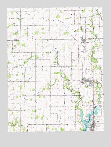
Arcadia, IN USGS Topographic Map
Click on map above to begin viewing in our Map Viewer.

This topographic map contains these locations and features:
Feature Name Type Latitude Longitude GNIS ID View Map
Albright CemeteryCemeteryN40.2174°W86.0712°430046View Map
ArcadiaPopulated PlaceN40.1759°W86.0217°430234View Map
Arcadia Christian ChurchChurchN40.1750°W86.0247°2096861View Map
Arcadia Church of the Brethren CemeteryCemeteryN40.1751°W86.0080°2101448View Map
Arcadia Police DepartmentBuildingN40.1760°W86.0237°2758283View Map
Arcadia Post OfficePost OfficeN40.1764°W86.0217°2101548View Map
Arcadia Public LibraryBuildingN40.1747°W86.0214°2101549View Map
Arcadia Town HallBuildingN40.1761°W86.0239°2101547View Map
AtlantaPopulated PlaceN40.2153°W86.0264°430329View Map
Atlanta Post OfficePost OfficeN40.2159°W86.0272°2096856View Map
Atlanta Public LibraryBuildingN40.2158°W86.0278°2101543View Map
Atlanta Town HallBuildingN40.2161°W86.0261°2101544View Map
Atlanta Town MarshalBuildingN40.2162°W86.0260°2758391View Map
Bacon Prairie CreekStreamN40.2425°W86.0055°430394View Map
Bee-Acre Farm StripAirportN40.2055°W86.0983°2677002View Map
Bennett DitchCanalN40.1798°W86.1069°430813View Map
Buscher DitchCanalN40.2270°W86.0253°431887View Map
Church of the BrethrenChurchN40.1758°W86.0081°2096864View Map
Cicero CemeteryCemeteryN40.1316°W86.0284°432519View Map
Cicero Police DepartmentBuildingN40.1315°W86.0152°2758175View Map
Cicero Post OfficePost OfficeN40.1314°W86.0158°2096858View Map
Cicero Town HallBuildingN40.1325°W86.0150°2101554View Map
Cicero United Methodist ChurchChurchN40.1325°W86.0117°2096865View Map
Cicero Wesleyan ChurchChurchN40.1297°W86.0164°2096866View Map
Crown Hill CemeteryCemeteryN40.1609°W86.0316°443065View Map
Doversberger DitchCanalN40.2311°W86.0475°433661View Map
Dunn CemeteryCemeteryN40.1576°W86.1175°433793View Map
Emanuel Lutheran CemeteryCemeteryN40.1691°W86.0000°2101449View Map
Emanuel Lutheran ChurchChurchN40.1733°W86.0144°2096862View Map
Goodykoontz CemeteryCemeteryN40.2325°W86.0288°435179View Map
Hamilton Heights Elementary SchoolSchoolN40.1552°W86.0151°2101551View Map
Hamilton Heights High SchoolSchoolN40.1650°W86.0156°2101550View Map
Hamilton Heights Middle SchoolSchoolN40.1769°W86.0261°2101545View Map
Hamilton Heights Primary SchoolSchoolN40.1571°W86.0170°2101552View Map
Heinzman Airport (historical)AirportN40.1800°W86.0125°449094View Map
Hurley CemeteryCemeteryN40.1901°W86.1076°2101447View Map
Indiana AcademySchoolN40.1484°W86.0122°436786View Map
Jackson Fire TerritoryBuildingN40.2139°W86.0266°2625812View Map
Jackson Township Fire Department Arcadia StationBuildingN40.1761°W86.0286°2101546View Map
Little Cicero CreekStreamN40.1464°W86.0305°438012View Map
MillersburgPopulated PlaceN40.1948°W86.0239°439233View Map
Mount Pleasant CemeteryCemeteryN40.1298°W86.1082°439661View Map
Mount Pleasant CemeteryCemeteryN40.1725°W86.0008°439663View Map
New Hope ChurchChurchN40.2461°W86.0275°440069View Map
Possum RunStreamN40.1728°W86.0069°2101536View Map
Prairie CreekStreamN40.2425°W86.1000°441547View Map
Red Bridge ParkParkN40.1308°W86.0253°2101553View Map
Roberts CemeteryCemeteryN40.1908°W86.1137°2101446View Map
Roberts ChapelChurchN40.1909°W86.1139°442153View Map
Sacred Heart of Jesus ChurchChurchN40.1281°W86.0178°2096868View Map
Salem ChurchChurchN40.1614°W86.1030°442918View Map
School Number 11 (historical)SchoolN40.1608°W86.0689°2101539View Map
School Number 13 (historical)SchoolN40.1461°W86.1083°2101542View Map
School Number 14 (historical)SchoolN40.1389°W86.0375°2101540View Map
School Number 18 (historical)SchoolN40.1322°W86.0608°2101541View Map
School Number 2 (historical)SchoolN40.2117°W86.0692°2101534View Map
School Number 5 (historical)SchoolN40.1756°W86.1075°2101538View Map
School Number 6 (historical)SchoolN40.1900°W86.0686°2101535View Map
School Number 8 (historical)SchoolN40.1756°W86.0239°2101537View Map
School Number 9 (historical)SchoolN40.2172°W86.1175°2101533View Map
Seventh Day Adventist Church SchoolSchoolN40.1314°W86.0086°446960View Map
Skyridge AirportAirportN40.1774°W86.1150°2677093View Map
Sumner CemeteryCemeteryN40.2251°W86.0144°444403View Map
Sun Rise FarmLocaleN40.2372°W86.1131°2650296View Map
Taylor CemeteryCemeteryN40.1567°W86.0998°451545View Map
Taylor CreekStreamN40.1811°W86.0550°444591View Map
Town of ArcadiaCivilN40.1743°W86.0211°2397435View Map
Town of AtlantaCivilN40.2135°W86.0266°2397443View Map
Township of JacksonCivilN40.1596°W86.0618°453446View Map

Note: Coordinates in the location and feature list above are referenced to NAD83 datum.


Copyright (C) 2008-2024 Ryan Niemi / Sunset Dynamics ... All Rights Reserved