TopoQuest Logo
Do you find TopoQuest useful?
Help keep TopoQuest running and adding new maps/features by donating!
Bitcoin:  19c7KJd3qBynnjoSw5npx9KScwjBe4ifkT
Litecoin:  LXs6TkuXGGXo1vDsWCkWVdjQX94eUKd6ui
Home View Maps Find Maps Find Places Resources & Links


East Chatham, New York Topographic Map

USGS Map Title: East Chatham, NY
USGS Map MRC: 42073D5
DRG (GeoTIFF) Download: o42073d5.tif


Neighboring USGS Topographic Map Quads:


  East Greenbush, NY  
42073E6
 

  Nassau, NY  
42073E5


  Kinderhook, NY  
42073D6
 

  East Chatham, NY  
42073D5


  Stottville, NY  
42073C6
 

  Chatham, NY  
42073C5


Map MRC Location:

N43°
W74°
N43°
W73°
H8 H7 H6 H5 H4 H3 H2 H1
G8 G7 G6 G5 G4 G3 G2 G1
F8 F7 F6 F5 F4 F3 F2 F1
E8 E7 E6 E5 E4 E3 E2 E1
D8 D7 D6 D5 D4 D3 D2 D1
C8 C7 C6 C5 C4 C3 C2 C1
B8 B7 B6 B5 B4 B3 B2 B1
A8 A7 A6 A5 A4 A3 A2 A1
N42°
W74°
N42°
W73°

East Chatham, NY USGS 1:24K Topographic Map Preview:
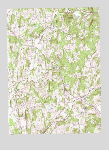
East Chatham, NY USGS Topographic Map
Click on map above to begin viewing in our Map Viewer.

This topographic map contains these locations and features:
Feature Name Type Latitude Longitude GNIS ID View Map
Ashley HillSummitN42.4865°W73.5429°942638View Map
Bachus PondLakeN42.4816°W73.5841°942761View Map
BrainardPopulated PlaceN42.4959°W73.5121°944601View Map
Breezy Hills Mobile Home ParkPopulated PlaceN42.3756°W73.5772°2496642View Map
Canaan Endpoint Toll PlazaLocaleN42.3983°W73.5052°2615136View Map
Cemetery of the MaplesCemeteryN42.4183°W73.5133°967285View Map
Chatham CenterPopulated PlaceN42.4181°W73.6140°946449View Map
Chatham Center United Methodist ChurchChurchN42.4178°W73.6128°2496370View Map
DeWitt Brown Road CemeteryCemeteryN42.3815°W73.5224°2555948View Map
East ChathamPopulated PlaceN42.4106°W73.5246°949040View Map
East Chatham Volunteer Fire CompanyBuildingN42.4099°W73.5232°2734756View Map
Frisbee CreekStreamN42.4054°W73.5221°950741View Map
Gale HillSummitN42.4834°W73.5037°950845View Map
Golden AcresPopulated PlaceN42.4036°W73.6181°2496618View Map
Green BrookStreamN42.4806°W73.5673°951666View Map
Kinderhook Creek BridgeBridgeN42.4974°W73.5301°2614932View Map
Malden BridgePopulated PlaceN42.4706°W73.5829°956300View Map
Mountain View CemeteryCemeteryN42.3986°W73.5251°957966View Map
New ConcordPopulated PlaceN42.3954°W73.5265°958403View Map
Old ChathamPopulated PlaceN42.4406°W73.5618°959263View Map
RayvillePopulated PlaceN42.4642°W73.5384°962254View Map
RidersPopulated PlaceN42.4729°W73.5432°973004View Map
Riders MillsPopulated PlaceN42.4809°W73.5640°962489View Map
Riders Mills SchoolSchoolN42.4745°W73.5634°962490View Map
Rock CityPopulated PlaceN42.4043°W73.5773°973016View Map
Saint Joseph ChurchChurchN42.4654°W73.5815°963707View Map
Shaker MuseumBuildingN42.4376°W73.5823°964920View Map
Stony KillStreamN42.4026°W73.6212°966575View Map
Sutherland PondLakeN42.4013°W73.5686°966867View Map
TGP-254 HeliportAirportN42.4814°W73.5628°975797View Map
The KnobitSummitN42.3831°W73.5059°967278View Map
Tonys NoseSummitN42.4342°W73.5634°967663View Map
Town of ChathamCivilN42.4249°W73.5810°978814View Map
Tri Village Volunteer Fire Company Chatham Center Station 2BuildingN42.4164°W73.6126°2734925View Map
Tri Village Volunteer Fire Company Malden Bridge Station 3BuildingN42.4649°W73.5815°2734815View Map
Tri Village Volunteer Fire Company Old Chatham Station 1BuildingN42.4405°W73.5579°2734816View Map
Tsatsawassa Protective Fire CompanyBuildingN42.4944°W73.5131°2735189View Map
Veeder Memorial ChurchChurchN42.4676°W73.5809°968477View Map

Note: Coordinates in the location and feature list above are referenced to NAD83 datum.


Copyright (C) 2008-2024 Ryan Niemi / Sunset Dynamics ... All Rights Reserved