TopoQuest Logo
Do you find TopoQuest useful?
Help keep TopoQuest running and adding new maps/features by donating!
Bitcoin:  19c7KJd3qBynnjoSw5npx9KScwjBe4ifkT
Litecoin:  LXs6TkuXGGXo1vDsWCkWVdjQX94eUKd6ui
Home View Maps Find Maps Find Places Resources & Links


Ebeemee Mountain, Maine Topographic Map

USGS Map Title: Ebeemee Mountain, ME
USGS Map MRC: 45069D1
DRG (GeoTIFF) Download: o45069d1.tif


Neighboring USGS Topographic Map Quads:


  Big Shanty Mountain, ME  
45069E2
 

  Jo-Mary Mountain, ME  
45069E1
 

  Ragged Mountain, ME  
45068E8
 

  Silver Lake, ME  
45069D2
 

  Ebeemee Mountain, ME  
45069D1
 

  Seboeis Lake, ME  
45068D8
 

  Sebec Lake East, ME  
45069C2
 

  Brownville Junction, ME  
45069C1
 

  Milo North, ME  
45068C8


Map MRC Location:

N46°
W70°
N46°
W69°
H8 H7 H6 H5 H4 H3 H2 H1
G8 G7 G6 G5 G4 G3 G2 G1
F8 F7 F6 F5 F4 F3 F2 F1
E8 E7 E6 E5 E4 E3 E2 E1
D8 D7 D6 D5 D4 D3 D2 D1
C8 C7 C6 C5 C4 C3 C2 C1
B8 B7 B6 B5 B4 B3 B2 B1
A8 A7 A6 A5 A4 A3 A2 A1
N45°
W70°
N45°
W69°

Ebeemee Mountain, ME USGS 1:24K Topographic Map Preview:
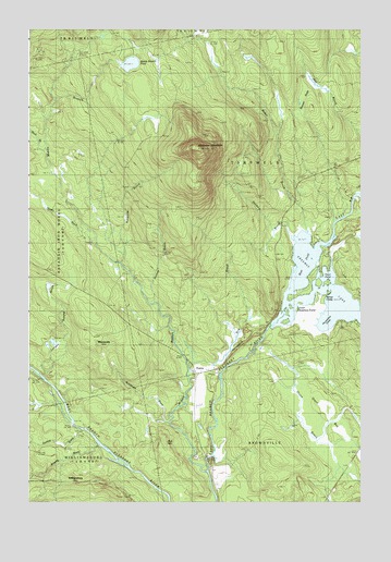
Ebeemee Mountain, ME USGS Topographic Map
Click on map above to begin viewing in our Map Viewer.

This topographic map contains these locations and features:
Feature Name Type Latitude Longitude GNIS ID View Map
Ashworth BrookStreamN45.4381°W69.0923°561327View Map
Babel BrookStreamN45.4475°W69.0203°561392View Map
Beaver BogsSwampN45.4823°W69.0225°561889View Map
Black BrookStreamN45.4653°W69.1223°562405View Map
Bog BrookStreamN45.4109°W69.0659°562653View Map
Bull HillSummitN45.3910°W69.0733°563159View Map
Ebeemee LakeLakeN45.4317°W69.0150°565760View Map
Ebeemee MountainSummitN45.4685°W69.0609°565761View Map
Ebeemee TownshipCivilN45.4632°W69.0385°2748760View Map
Homes BrookStreamN45.4278°W69.0787°568230View Map
HorsebackRidgeN45.4167°W69.0456°568292View Map
Horseshoe PondLakeN45.4245°W69.0112°568322View Map
Hungry BrookStreamN45.4428°W69.1034°568455View Map
Juniper Swamp BrookStreamN45.4092°W69.1242°569032View Map
Lower Ebeemee PondLakeN45.4264°W69.0256°570495View Map
Middle Branch Pleasant RiverStreamN45.3834°W69.0592°571218View Map
Middle Branch PondLakeN45.4909°W69.0867°571220View Map
MooresvillePopulated PlaceN45.4142°W69.0998°579535View Map
Mooresville BrookStreamN45.3962°W69.0742°571570View Map
Number Two TrailTrailN45.4803°W69.1112°572189View Map
Orson BogSwampN45.3909°W69.0073°572783View Map
Orson BrookStreamN45.4131°W69.0434°572784View Map
Pearl PondLakeN45.4356°W69.0112°573112View Map
PrairiePopulated PlaceN45.4087°W69.0639°579636View Map
Roaring BrookStreamN45.3934°W69.1073°574276View Map
Stinking BrookStreamN45.4448°W69.0256°576356View Map
Stinking BrookStreamN45.3959°W69.1112°576358View Map
Strout CampLocaleN45.4303°W69.0128°576445View Map
West PondLakeN45.4290°W69.0107°578205View Map
WilliamsburgPopulated PlaceN45.3801°W69.1159°579839View Map

Note: Coordinates in the location and feature list above are referenced to NAD83 datum.


Copyright (C) 2008-2024 Ryan Niemi / Sunset Dynamics ... All Rights Reserved