TopoQuest Logo
Do you find TopoQuest useful?
Help keep TopoQuest running and adding new maps/features by donating!
Bitcoin:  19c7KJd3qBynnjoSw5npx9KScwjBe4ifkT
Litecoin:  LXs6TkuXGGXo1vDsWCkWVdjQX94eUKd6ui
Home View Maps Find Maps Find Places Resources & Links


Eden Ridge, Oregon Topographic Map

USGS Map Title: Eden Ridge, OR
USGS Map MRC: 45117H5
DRG (GeoTIFF) Download: o45117h5.tif


Neighboring USGS Topographic Map Quads:


  Oregon Butte, WA  
46117A6
 

  Diamond Peak, WA  
46117A5
 

  Saddle Butte, WA  
46117A4
 

  Elbow Creek, OR  
45117H6
 

  Eden Ridge, OR  
45117H5
 

  Troy, OR  
45117H4
 

  Deep Creek, OR  
45117G6
 

  Promise, OR  
45117G5
 

  Wood Butte, OR  
45117G4


Map MRC Location:

N46°
W118°
N46°
W117°
H8 H7 H6 H5 H4 H3 H2 H1
G8 G7 G6 G5 G4 G3 G2 G1
F8 F7 F6 F5 F4 F3 F2 F1
E8 E7 E6 E5 E4 E3 E2 E1
D8 D7 D6 D5 D4 D3 D2 D1
C8 C7 C6 C5 C4 C3 C2 C1
B8 B7 B6 B5 B4 B3 B2 B1
A8 A7 A6 A5 A4 A3 A2 A1
N45°
W118°
N45°
W117°

Eden Ridge, OR USGS 1:24K Topographic Map Preview:
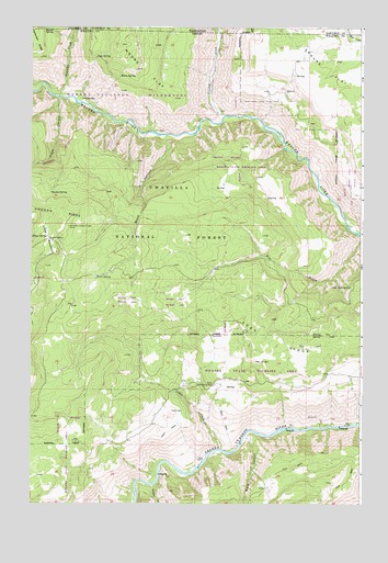
Eden Ridge, OR USGS Topographic Map
Click on map above to begin viewing in our Map Viewer.

This topographic map contains these locations and features:
Feature Name Type Latitude Longitude GNIS ID View Map
Bobcat SpringSpringN45.9990°W117.6172°1117889View Map
Burnt CanyonValleyN45.9715°W117.5744°1118347View Map
Cabin CreekStreamN45.8890°W117.5538°1118441View Map
Crooked CreekStreamN45.9768°W117.5530°1119561View Map
Crooked CreekStreamN45.9768°W117.5516°1504283View Map
Cross CanyonValleyN45.9810°W117.6149°1119574View Map
Cummings SpringSpringN45.8985°W117.6149°1129485View Map
Dan Cold SpringSpringN45.9320°W117.5046°1119678View Map
EdenPopulated PlaceN45.9068°W117.5566°1129486View Map
Eden CemeteryCemeteryN45.8995°W117.5721°1120390View Map
Eden Community HallLocaleN45.9063°W117.5568°1120392View Map
Eden Post Office (historical)Post OfficeN45.9068°W117.5566°1165198View Map
Eden RidgeRidgeN45.9160°W117.5152°1120393View Map
Elbow SpringSpringN45.9448°W117.6191°1120424View Map
Fairview BarBarN45.9810°W117.6069°1120568View Map
Fairview CreekStreamN45.9818°W117.6146°1120575View Map
Fairview CreekStreamN45.9821°W117.6149°1504808View Map
Fenton SpringSpringN45.9191°W117.5155°1120670View Map
Hoodoo Lookout TowerTowerN45.9477°W117.6108°1163720View Map
Hoodoo SpringSpringN45.9565°W117.6178°1121965View Map
Long MeadowsFlatN45.9440°W117.6185°1123438View Map
Long Meadows Guard StationBuildingN45.9449°W117.6183°2754362View Map
Moore FlatFlatN45.9888°W117.5830°1124332View Map
Moore FlatFlatN45.9999°W117.5827°1506780View Map
Moore SpringSpringN45.9873°W117.5921°1124334View Map
Sickfoot CreekStreamN45.8796°W117.5799°1126945View Map
Soap SpringSpringN45.9921°W117.6008°1127180View Map
Thorn SpringSpringN45.9347°W117.6013°1128049View Map
Ward CanyonValleyN45.8929°W117.5443°1151884View Map

Note: Coordinates in the location and feature list above are referenced to NAD83 datum.


Copyright (C) 2008-2024 Ryan Niemi / Sunset Dynamics ... All Rights Reserved