TopoQuest Logo
Do you find TopoQuest useful?
Help keep TopoQuest running and adding new maps/features by donating!
Bitcoin:  19c7KJd3qBynnjoSw5npx9KScwjBe4ifkT
Litecoin:  LXs6TkuXGGXo1vDsWCkWVdjQX94eUKd6ui
Home View Maps Find Maps Find Places Resources & Links


Edwards, Colorado Topographic Map

USGS Map Title: Edwards, CO
USGS Map MRC: 39106F5
DRG (GeoTIFF) Download: o39106f5.tif


Neighboring USGS Topographic Map Quads:


  State Bridge, CO  
39106G6
 

  Lava Creek, CO  
39106G5
 

  Piney Peak, CO  
39106G4
 

  Wolcott, CO  
39106F6
 

  Edwards, CO  
39106F5
 

  Vail West, CO  
39106F4
 

  Fulford, CO  
39106E6
 

  Grouse Mountain, CO  
39106E5
 

  Minturn, CO  
39106E4


Map MRC Location:

N40°
W107°
N40°
W106°
H8 H7 H6 H5 H4 H3 H2 H1
G8 G7 G6 G5 G4 G3 G2 G1
F8 F7 F6 F5 F4 F3 F2 F1
E8 E7 E6 E5 E4 E3 E2 E1
D8 D7 D6 D5 D4 D3 D2 D1
C8 C7 C6 C5 C4 C3 C2 C1
B8 B7 B6 B5 B4 B3 B2 B1
A8 A7 A6 A5 A4 A3 A2 A1
N39°
W107°
N39°
W106°

Edwards, CO USGS 1:24K Topographic Map Preview:
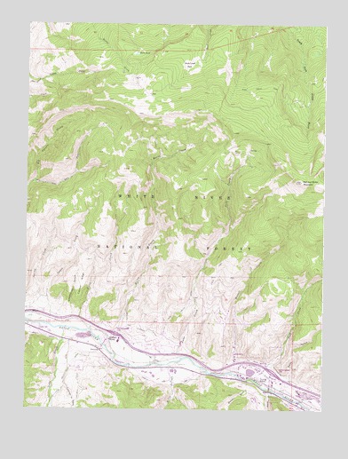
Edwards, CO USGS Topographic Map
Click on map above to begin viewing in our Map Viewer.

This topographic map contains these locations and features:
Feature Name Type Latitude Longitude GNIS ID View Map
Arrowhead Claims MineMineN39.7219°W106.5256°1684180View Map
Arrowhead Number One MineMineN39.7058°W106.5286°1684179View Map
Arrowhead VillagePopulated PlaceN39.6344°W106.5670°2571071View Map
AvonPopulated PlaceN39.6314°W106.5223°204667View Map
Avon Police DepartmentBuildingN39.6357°W106.5285°2735527View Map
Avon Post OfficePost OfficeN39.6369°W106.5234°2734627View Map
Avon SidingLocaleN39.6342°W106.5245°175897View Map
B and B Edwards PitMineN39.6397°W106.5609°1684181View Map
Bachelor GulchValleyN39.6313°W106.5318°175884View Map
Battle Mountain High SchoolSchoolN39.6452°W106.5833°176130View Map
Beard CreekStreamN39.6508°W106.6023°175901View Map
Beaver CreekStreamN39.6314°W106.5214°175883View Map
Benchmark Lake DamDamN39.6367°W106.5289°200542View Map
Benchmark Lake ReservoirReservoirN39.6373°W106.5303°200543View Map
Berry CreekStreamN39.6480°W106.5939°175905View Map
Brett DitchCanalN39.6478°W106.6153°175890View Map
Brett Family CemeteryCemeteryN39.6478°W106.6114°2107147View Map
Buck CreekStreamN39.6344°W106.5281°175881View Map
Casteel RidgeRidgeN39.6658°W106.6017°175891View Map
Clark Spring ReservoirReservoirN39.7359°W106.5910°197786View Map
Country Club of the RockiesLocaleN39.6373°W106.5654°2571075View Map
Creamery DitchCanalN39.6275°W106.6036°202336View Map
Creamery GulchValleyN39.6327°W106.6090°175886View Map
Dead Buck ReservoirReservoirN39.6651°W106.5650°197683View Map
Deadhorse GulchValleyN39.6532°W106.6061°175903View Map
Dodd DitchCanalN39.6411°W106.6048°175887View Map
Eagle County Ambulance District Edwards StationBuildingN39.6453°W106.5975°2735562View Map
Eagle River Fire Protection District Station 12 EdwardsBuildingN39.6453°W106.5976°2666975View Map
Eagle River Fire Protection District Station 7 AvonBuildingN39.6353°W106.5274°2666878View Map
Eagle River Fire Protection District Station 8 WildridgeBuildingN39.6553°W106.5407°2667084View Map
East Beard ReservoirReservoirN39.6934°W106.5832°197693View Map
East Fork Red Canyon CreekStreamN39.6986°W106.6225°175904View Map
EdwardsPopulated PlaceN39.6450°W106.5942°204666View Map
Edwards CemeteryCemeteryN39.6417°W106.5703°2107150View Map
Edwards Post OfficePost OfficeN39.6446°W106.5974°2734565View Map
Edwards SidingLocaleN39.6475°W106.5898°175889View Map
Fez SpringSpringN39.7386°W106.6209°197697View Map
Horse PondLakeN39.7403°W106.5795°175907View Map
Howard and Winslow DitchCanalN39.6500°W106.5761°175893View Map
Howard DitchCanalN39.6422°W106.5664°175894View Map
Indian Grove ReservoirReservoirN39.7053°W106.5908°197687View Map
James Spring ReservoirReservoirN39.7349°W106.5904°197700View Map
Jouflas Spring ReservoirReservoirN39.7370°W106.6102°197698View Map
June CreekStreamN39.6408°W106.5609°175900View Map
June Creek DamDamN39.6467°W106.5606°200580View Map
June Creek DitchCanalN39.6567°W106.5598°175892View Map
June Creek ReservoirReservoirN39.6467°W106.5597°200581View Map
Lake CreekStreamN39.6514°W106.6086°175885View Map
Lake Creek SchoolSchoolN39.6469°W106.6061°175888View Map
Lost Reservoir Number OneReservoirN39.6759°W106.5837°197684View Map
Lost Reservoir Number ThreeReservoirN39.6847°W106.5796°197686View Map
Lost Reservoir Number TwoReservoirN39.6742°W106.5806°197685View Map
Lower Beard Number One ReservoirReservoirN39.6802°W106.5872°197694View Map
McCoy CreekStreamN39.6397°W106.5650°175896View Map
Metcalf CreekStreamN39.6408°W106.5375°175899View Map
Metcalf DitchCanalN39.6353°W106.5225°175898View Map
Nottingham and Puder DitchCanalN39.6292°W106.5067°202334View Map
Red and White MountainSummitN39.6994°W106.5103°202333View Map
Rock Creek ParkFlatN39.7372°W106.5548°175906View Map
Rock Creek TrailTrailN39.7275°W106.5181°202337View Map
Sonnenalp Resort of VailLocaleN39.6483°W106.5717°2571078View Map
Spring CreekStreamN39.6536°W106.6245°175880View Map
Spring Creek Number One ReservoirReservoirN39.6767°W106.6132°197690View Map
Spring Creek Number Two ReservoirReservoirN39.6792°W106.6154°197691View Map
Swift GulchValleyN39.6357°W106.5152°175882View Map
Tames CreekStreamN39.6530°W106.6175°175902View Map
Tames Number One ReservoirReservoirN39.6805°W106.6036°197688View Map
Tames Number Two ReservoirReservoirN39.6776°W106.6044°197689View Map
Terrell and Ford DitchCanalN39.6336°W106.5581°175895View Map
Town of AvonCivilN39.6448°W106.5138°2411658View Map
Ute Spring ReservoirReservoirN39.7239°W106.6224°197699View Map
Ute Spring Reservoir DamDamN39.7239°W106.6220°197696View Map
West Beard ReservoirReservoirN39.6890°W106.5857°197692View Map

Note: Coordinates in the location and feature list above are referenced to NAD83 datum.


Copyright (C) 2008-2025 Ryan Niemi / Sunset Dynamics ... All Rights Reserved