TopoQuest Logo
Do you find TopoQuest useful?
Help keep TopoQuest running and adding new maps/features by donating!
Bitcoin:  19c7KJd3qBynnjoSw5npx9KScwjBe4ifkT
Litecoin:  LXs6TkuXGGXo1vDsWCkWVdjQX94eUKd6ui
Home View Maps Find Maps Find Places Resources & Links


El Dado Mesa, New Mexico Topographic Map

USGS Map Title: El Dado Mesa, NM
USGS Map MRC: 35107D4
DRG (GeoTIFF) Download: o35107d4.tif


Neighboring USGS Topographic Map Quads:


  El Dado, NM  
35107E5
 

  Mesa Cortada, NM  
35107E4
 

  Cerro Parido, NM  
35107E3
 

  Cerro Alesna, NM  
35107D5
 

  El Dado Mesa, NM  
35107D4
 

  Laguna Seca, NM  
35107D3
 

  Cerro Pelon, NM  
35107C5
 

  Laguna Canoneros, NM  
35107C4
 

  Marquez, NM  
35107C3


Map MRC Location:

N36°
W108°
N36°
W107°
H8 H7 H6 H5 H4 H3 H2 H1
G8 G7 G6 G5 G4 G3 G2 G1
F8 F7 F6 F5 F4 F3 F2 F1
E8 E7 E6 E5 E4 E3 E2 E1
D8 D7 D6 D5 D4 D3 D2 D1
C8 C7 C6 C5 C4 C3 C2 C1
B8 B7 B6 B5 B4 B3 B2 B1
A8 A7 A6 A5 A4 A3 A2 A1
N35°
W108°
N35°
W107°

El Dado Mesa, NM USGS 1:24K Topographic Map Preview:
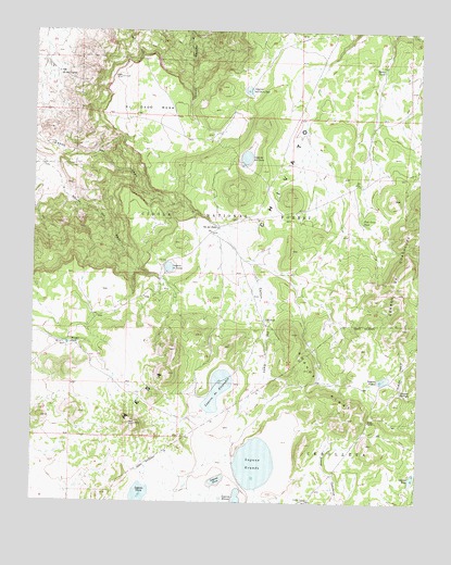
El Dado Mesa, NM USGS Topographic Map
Click on map above to begin viewing in our Map Viewer.

This topographic map contains these locations and features:
Feature Name Type Latitude Longitude GNIS ID View Map
Alejandro Water TankReservoirN35.4070°W107.4481°914208View Map
Cerros De AlejandroSummitN35.4153°W107.4542°914207View Map
ED-7 Water WellWellN35.3800°W107.4987°922839View Map
El Dado MesaSummitN35.4795°W107.4620°906046View Map
Fishback DamDamN35.4067°W107.4423°923834View Map
Grande CampLocaleN35.3759°W107.4109°906679View Map
Grande RidgeRidgeN35.4020°W107.4009°906680View Map
Heller TankReservoirN35.4900°W107.3874°906909View Map
J B TankReservoirN35.4237°W107.4254°907278View Map
La Vera SpringSpringN35.4369°W107.4674°914209View Map
Laguna BlancaLakeN35.3754°W107.4338°907762View Map
Laguna BorregosReservoirN35.4046°W107.3812°907766View Map
Laguna ChuteLakeN35.3770°W107.4651°907770View Map
Laguna de AlejandroLakeN35.4048°W107.4403°907749View Map
Laguna de CosmeLakeN35.4371°W107.4568°907750View Map
Laguna del CerroLakeN35.4664°W107.4319°907753View Map
Laguna del Cerro RojoLakeN35.4844°W107.4316°907754View Map
Laguna GrandeLakeN35.3854°W107.4280°907777View Map
Laguna NieveLakeN35.3809°W107.4403°907787View Map
Laguna PiedraLakeN35.4077°W107.3866°907790View Map
Laguna PinoLakeN35.3817°W107.3770°907793View Map
Ojo de las YeguasSpringN35.4887°W107.4928°909289View Map
Ojo del DadoSpringN35.4479°W107.4413°909295View Map
Pine Grove TankReservoirN35.4491°W107.3936°909667View Map
Ranger TankReservoirN35.4170°W107.4891°910011View Map

Note: Coordinates in the location and feature list above are referenced to NAD83 datum.


Copyright (C) 2008-2024 Ryan Niemi / Sunset Dynamics ... All Rights Reserved