TopoQuest Logo
Do you find TopoQuest useful?
Help keep TopoQuest running and adding new maps/features by donating!
Bitcoin:  19c7KJd3qBynnjoSw5npx9KScwjBe4ifkT
Litecoin:  LXs6TkuXGGXo1vDsWCkWVdjQX94eUKd6ui
Home View Maps Find Maps Find Places Resources & Links


Argillite, Kentucky Topographic Map

USGS Map Title: Argillite, KY
USGS Map MRC: 38082D7
DRG (GeoTIFF) Download: o38082d7.tif


Neighboring USGS Topographic Map Quads:


  Load, KY  
38082E8
 

  Greenup, KY  
38082E7
 

  Ironton, OH  
38082E6
 

  Oldtown, KY  
38082D8
 

  Argillite, KY  
38082D7
 

  Ashland, KY  
38082D6
 

  Grayson, KY  
38082C8
 

  Rush, KY  
38082C7
 

  Boltsfork, KY  
38082C6


Map MRC Location:

N39°
W83°
N39°
W82°
H8 H7 H6 H5 H4 H3 H2 H1
G8 G7 G6 G5 G4 G3 G2 G1
F8 F7 F6 F5 F4 F3 F2 F1
E8 E7 E6 E5 E4 E3 E2 E1
D8 D7 D6 D5 D4 D3 D2 D1
C8 C7 C6 C5 C4 C3 C2 C1
B8 B7 B6 B5 B4 B3 B2 B1
A8 A7 A6 A5 A4 A3 A2 A1
N38°
W83°
N38°
W82°

Argillite, KY USGS 1:24K Topographic Map Preview:
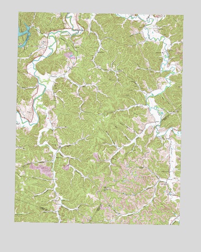
Argillite, KY USGS Topographic Map
Click on map above to begin viewing in our Map Viewer.

This topographic map contains these locations and features:
Feature Name Type Latitude Longitude GNIS ID View Map
ArgillitePopulated PlaceN38.4898°W82.8282°507409View Map
Argillite Lookout TowerTowerN38.4609°W82.8052°517087View Map
Bear BranchStreamN38.4529°W82.7657°486540View Map
Brush CreekStreamN38.4334°W82.7691°488067View Map
Brush Creek ChurchChurchN38.4306°W82.7785°488083View Map
Buena Vista BranchStreamN38.3992°W82.7682°488295View Map
Buena Vista Iron Furnace (historical)LocaleN38.3947°W82.7585°2089052View Map
Buena Vista SchoolSchoolN38.3964°W82.7681°2089053View Map
Callihan CemeteryCemeteryN38.4404°W82.8638°488623View Map
Cane CreekStreamN38.4420°W82.8607°488773View Map
Cane Creek CemeteryCemeteryN38.3881°W82.8424°488774View Map
Cane Creek ChurchChurchN38.3865°W82.8393°488776View Map
Caudle BranchStreamN38.3954°W82.8454°489109View Map
Chadwick CreekStreamN38.4529°W82.7727°489300View Map
Claylick CreekStreamN38.4856°W82.8504°489592View Map
Click CemeteryCemeteryN38.4030°W82.7539°2089051View Map
Coal BranchStreamN38.4179°W82.8427°489726View Map
Cobb ForkStreamN38.4012°W82.7663°489751View Map
Culp Creek ChapelChurchN38.4773°W82.8141°490467View Map
DanleytonPopulated PlaceN38.4917°W82.7693°507812View Map
Danleyton ChurchChurchN38.4792°W82.7602°490580View Map
Danleyton SchoolSchoolN38.4776°W82.7652°490581View Map
Dugan BranchStreamN38.4204°W82.7966°491265View Map
Eastern Kentucky Railway Historical MarkerParkN38.4915°W82.8298°2745102View Map
Eastern Kentucky Railway in Hunnewell Historical MarkerParkN38.4635°W82.8397°2745103View Map
Far Fork Sandsuck CreekStreamN38.4576°W82.8291°491982View Map
Greenbo LakeReservoirN38.4864°W82.8733°493306View Map
Grizzle CemeteryCemeteryN38.4967°W82.8232°493411View Map
Henry BranchStreamN38.4912°W82.7777°494056View Map
High KnobSummitN38.3954°W82.8057°494185View Map
Howard CemeteryCemeteryN38.4565°W82.8471°494669View Map
HunnewellPopulated PlaceN38.4134°W82.8454°508296View Map
Hunnewell CemeteryCemeteryN38.4209°W82.8432°494766View Map
Indian RunStreamN38.4973°W82.7718°494981View Map
John BranchStreamN38.4245°W82.7849°495320View Map
Kentucky Veterans Cemetery NortheastCemeteryN38.3838°W82.8197°2775096View Map
Kimbler Post Office (historical)Post OfficeN38.4318°W82.7545°2089046View Map
Kirby FlatsFlatN38.4204°W82.7641°495786View Map
Kirby Flats CemeteryCemeteryN38.4270°W82.7624°495787View Map
Kirby Flats SchoolSchoolN38.4288°W82.7545°2089047View Map
Little Sandy Volunteer Fire Department Station 2BuildingN38.4894°W82.8291°2637391View Map
Little Sandy Volunteer Fire Department Station 3BuildingN38.4851°W82.7622°2637392View Map
Lock HollowValleyN38.4221°W82.7845°496928View Map
Logtown HollowValleyN38.3858°W82.8396°496993View Map
Long BranchStreamN38.4573°W82.8579°497079View Map
Lost LickStreamN38.4462°W82.7757°497194View Map
McCall HollowValleyN38.4003°W82.8466°497768View Map
McCalvin CemeteryCemeteryN38.4090°W82.7871°2089054View Map
Moore BranchStreamN38.3804°W82.7954°498534View Map
NaplesPopulated PlaceN38.4359°W82.7696°508670View Map
Naples Post Office (historical)Post OfficeN38.4324°W82.7689°2089045View Map
Near Fork Sandsuck CreekStreamN38.4576°W82.8291°499204View Map
Old Stream BranchStreamN38.4967°W82.7766°499888View Map
Patrick BranchStreamN38.3823°W82.8424°500243View Map
Pigott BranchStreamN38.4662°W82.7649°500611View Map
Reeves CemeteryCemeteryN38.4815°W82.8541°501709View Map
Sand Gap ChurchChurchN38.4401°W82.8102°502905View Map
Sandsuck CreekStreamN38.4615°W82.8591°502968View Map
Sawmill BranchStreamN38.4309°W82.8485°503012View Map
Sinking BranchStreamN38.4804°W82.8491°503558View Map
Skillet Handle BranchStreamN38.4270°W82.7824°503605View Map
Straight CreekStreamN38.4004°W82.7602°504547View Map
Straight Creek ChurchChurchN38.3992°W82.7604°504552View Map
Tough BranchStreamN38.4445°W82.7704°505367View Map
Tunnel BranchStreamN38.4106°W82.8457°505567View Map
Turkey LickStreamN38.4148°W82.8446°505617View Map
Wayside ChurchChurchN38.4265°W82.7585°506312View Map
Wildcat HollowValleyN38.4854°W82.8426°506738View Map
Williams CreekStreamN38.4292°W82.7616°506818View Map
Williams CreekPost OfficeN38.4068°W82.7584°2089049View Map
Williams Creek ChurchChurchN38.4067°W82.7579°506820View Map
Williams Creek ChurchChurchN38.4068°W82.7584°2089050View Map
Wurtland DivisionCivilN38.4655°W82.8080°1937330View Map

Note: Coordinates in the location and feature list above are referenced to NAD83 datum.


Copyright (C) 2008-2025 Ryan Niemi / Sunset Dynamics ... All Rights Reserved