TopoQuest Logo
Do you find TopoQuest useful?
Help keep TopoQuest running and adding new maps/features by donating!
Bitcoin:  19c7KJd3qBynnjoSw5npx9KScwjBe4ifkT
Litecoin:  LXs6TkuXGGXo1vDsWCkWVdjQX94eUKd6ui
Home View Maps Find Maps Find Places Resources & Links


Ellamore, West Virginia Topographic Map

USGS Map Title: Ellamore, WV
USGS Map MRC: 38080H1
DRG (GeoTIFF) Download: o38080h1.tif


Neighboring USGS Topographic Map Quads:


  Century, WV  
39080A2
 

  Audra, WV  
39080A1
 

  Belington, WV  
39079A8
 

  Buckhannon, WV  
38080H2
 

  Ellamore, WV  
38080H1
 

  Junior, WV  
38079H8
 

  Alton, WV  
38080G2
 

  Cassity, WV  
38080G1
 

  Beverly West, WV  
38079G8


Map MRC Location:

N39°
W81°
N39°
W80°
H8 H7 H6 H5 H4 H3 H2 H1
G8 G7 G6 G5 G4 G3 G2 G1
F8 F7 F6 F5 F4 F3 F2 F1
E8 E7 E6 E5 E4 E3 E2 E1
D8 D7 D6 D5 D4 D3 D2 D1
C8 C7 C6 C5 C4 C3 C2 C1
B8 B7 B6 B5 B4 B3 B2 B1
A8 A7 A6 A5 A4 A3 A2 A1
N38°
W81°
N38°
W80°

Ellamore, WV USGS 1:24K Topographic Map Preview:
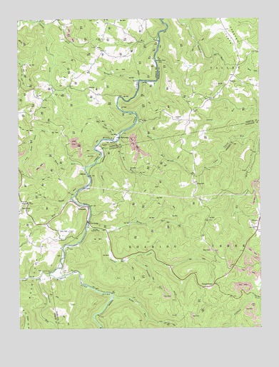
Ellamore, WV USGS Topographic Map
Click on map above to begin viewing in our Map Viewer.

This topographic map contains these locations and features:
Feature Name Type Latitude Longitude GNIS ID View Map
Bentley Y (historical)LocaleN38.9293°W80.1137°1696645View Map
Brook RunStreamN38.9137°W80.0798°1536387View Map
Burke School (historical)SchoolN38.9576°W80.1062°1696658View Map
Burnt BridgeLocaleN38.9179°W80.0892°1536760View Map
Camp MahoneqanLocaleN38.9515°W80.0759°1536934View Map
Chestnut FlatsFlatN38.9923°W80.0142°1537271View Map
Deen KnobSummitN38.9907°W80.1170°1696679View Map
Devil RunStreamN38.9595°W80.0634°1538154View Map
Durrett CemeteryCemeteryN38.9629°W80.0348°1538457View Map
Durrett Church (historical)ChurchN38.9629°W80.0348°1697051View Map
EllamorePopulated PlaceN38.9243°W80.0904°1554388View Map
Ellamore School SpringSpringN38.9207°W80.0945°1678169View Map
Ellamore Volunteer Fire DepartmentBuildingN38.9216°W80.1051°2578053View Map
Fair Hope School (historical)SchoolN38.9307°W80.0034°1726997View Map
Fairview ChurchChurchN38.8984°W80.1134°1538814View Map
Fairview School (historical)SchoolN38.8984°W80.1123°1696682View Map
Finegan FordPopulated PlaceN38.9840°W80.0526°1554453View Map
GalePopulated PlaceN38.9045°W80.1034°1554523View Map
GormleyPopulated PlaceN38.9723°W80.0890°1554586View Map
Gormley School (historical)SchoolN38.9720°W80.0884°1696698View Map
Gum RunStreamN38.9270°W80.0976°1539789View Map
Hanging Run School (historical)SchoolN38.9904°W80.0317°1697077View Map
Hooppole RunStreamN38.9751°W80.0620°1540435View Map
JimtownPopulated PlaceN38.9184°W80.0009°1554810View Map
Kettle RunStreamN38.8882°W80.0776°1541174View Map
Kettle Run School (historical)SchoolN38.8895°W80.0765°1727012View Map
King Summit School (historical)SchoolN38.8995°W80.0048°1727013View Map
KingsvillePopulated PlaceN38.9337°W80.0342°1549773View Map
Kingsville Post Office (historical)Post OfficeN38.9298°W80.0342°1727014View Map
LantzPopulated PlaceN38.9495°W80.0817°1697095View Map
Latham School (historical)SchoolN38.9334°W80.1237°1696722View Map
Laurel CreekStreamN38.9165°W80.0898°1541408View Map
Laurel Creek School (historical)SchoolN38.9068°W80.0776°1727017View Map
Laurel RunStreamN38.9929°W80.0520°1541508View Map
Laurel RunStreamN38.8754°W80.1212°1541540View Map
LoopLocaleN38.9384°W80.0070°1542450View Map
Middle Fork (historical)Populated PlaceN38.9134°W80.0790°1727024View Map
Middle Fork River Trail BridgeBridgeN38.9375°W80.0892°2647391View Map
MidvalePopulated PlaceN38.9373°W80.0898°1555115View Map
Mount Nebo ChurchChurchN38.9918°W80.0809°1543686View Map
Mount Zion CemeteryCemeteryN38.9690°W80.1159°1543804View Map
Nay ChapelChurchN38.9259°W80.1204°1544060View Map
NeboPopulated PlaceN38.9884°W80.0845°1549846View Map
Nebo School (historical)SchoolN38.9895°W80.0840°1696743View Map
OrrPopulated PlaceN38.9398°W80.0537°1555275View Map
Osborne RunStreamN38.8957°W80.1151°1544454View Map
Phillips ChurchChurchN38.9157°W80.0040°1544784View Map
PumpkintownPopulated PlaceN38.8929°W80.0242°1545314View Map
Right Fork Middle Fork RiverStreamN38.8965°W80.1095°1552662View Map
Roaring Creek DistrictCivilN38.8978°W80.0096°1928345View Map
Sand ForkStreamN38.9979°W80.1109°1546349View Map
Sand RunPopulated PlaceN38.9232°W80.1242°1555564View Map
Service RunStreamN38.9523°W80.0734°1546580View Map
Short RunStreamN38.9429°W80.0845°1546732View Map
Straight RunStreamN38.9045°W80.0662°1547572View Map
TalbottPopulated PlaceN38.9770°W80.0134°1549951View Map
Talbott Methodist Episcopal ChurchChurchN38.9676°W80.0254°1697188View Map
Tall Oaks Roadside ParkParkN38.9157°W80.0859°1547878View Map
VeganPopulated PlaceN38.9640°W80.1137°1555882View Map
Water Camp School (historical)SchoolN38.9729°W80.0348°1697201View Map
White Oak RunStreamN38.9398°W80.0904°1549065View Map
YokumPopulated PlaceN38.9751°W80.0626°1556039View Map

Note: Coordinates in the location and feature list above are referenced to NAD83 datum.


Copyright (C) 2008-2024 Ryan Niemi / Sunset Dynamics ... All Rights Reserved