TopoQuest Logo
Do you find TopoQuest useful?
Help keep TopoQuest running and adding new maps/features by donating!
Bitcoin:  19c7KJd3qBynnjoSw5npx9KScwjBe4ifkT
Litecoin:  LXs6TkuXGGXo1vDsWCkWVdjQX94eUKd6ui
Home View Maps Find Maps Find Places Resources & Links


Ariel, Florida Topographic Map

USGS Map Title: Ariel, FL
USGS Map MRC: 28080H7
DRG (GeoTIFF) Download: o28080h7.tif


Neighboring USGS Topographic Map Quads:


  New Smyrna Beach, FL  
29080A8


  Edgewater, FL  
28080H8
 

  Ariel, FL  
28080H7


  Maytown, FL  
28080G8
 

  Oak Hill, FL  
28080G7
 

  Pardon Island, FL  
28080G6


Map MRC Location:

N29°
W81°
N29°
W80°
H8 H7 H6 H5 H4 H3 H2 H1
G8 G7 G6 G5 G4 G3 G2 G1
F8 F7 F6 F5 F4 F3 F2 F1
E8 E7 E6 E5 E4 E3 E2 E1
D8 D7 D6 D5 D4 D3 D2 D1
C8 C7 C6 C5 C4 C3 C2 C1
B8 B7 B6 B5 B4 B3 B2 B1
A8 A7 A6 A5 A4 A3 A2 A1
N28°
W81°
N28°
W80°

Ariel, FL USGS 1:24K Topographic Map Preview:
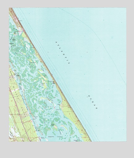
Ariel, FL USGS Topographic Map
Click on map above to begin viewing in our Map Viewer.

This topographic map contains these locations and features:
Feature Name Type Latitude Longitude GNIS ID View Map
ArielPopulated PlaceN28.9005°W80.8637°294656View Map
Bethune BeachPopulated PlaceN28.9492°W80.8378°301652View Map
Bissitte BayBayN28.8981°W80.8453°278869View Map
Bittersweet CoveBayN28.9137°W80.8596°278871View Map
Blue HoleBayN28.9361°W80.8662°279026View Map
Botheration CreekBayN28.9721°W80.8718°279268View Map
Bottle IslandIslandN28.9703°W80.8692°279271View Map
Bottle Island CreekBayN28.9643°W80.8694°279272View Map
Brickhouse CoveBayN28.9243°W80.8613°279378View Map
Cedar CreekBayN28.9552°W80.8550°280179View Map
Cedar IslandIslandN28.9483°W80.8487°280206View Map
City of Oak HillCivilN28.8784°W80.8351°2404408View Map
EldoraPopulated PlaceN28.9092°W80.8198°282146View Map
Fox SlipBayN28.9580°W80.8657°282774View Map
Gaines IslandIslandN28.8908°W80.8262°282872View Map
Gaines SloughBayN28.8858°W80.8212°282873View Map
Hacienda del Rio Mobile Home ParkPopulated PlaceN28.9288°W80.8704°2448817View Map
Moeller CampLocaleN28.9294°W80.8253°287048View Map
New Smyrna Beach DivisionCivilN28.9289°W80.8527°1935865View Map
Oak Hill Church of the NazareneChurchN28.8858°W80.8578°2451271View Map
Oak Hill DockLocaleN28.8789°W80.8406°287974View Map
Orange IslandIslandN28.9125°W80.8306°288210View Map
Orange Island CreekBayN28.9154°W80.8325°288211View Map
Oyster BayBayN28.9575°W80.8614°288333View Map
Packwood PlacePopulated PlaceN28.9380°W80.8695°295522View Map
Pumpkin PointCapeN28.9053°W80.8201°289372View Map
Riverbreeze Park Mobile Home ParkPopulated PlaceN28.8944°W80.8504°2451265View Map
Riverwood Park Campground MarinaHarborN28.8938°W80.8496°2451261View Map
Shipyard CanalCanalN28.9450°W80.8484°291059View Map
Shipyard IslandIslandN28.9286°W80.8384°291061View Map
Slippery CreekBayN28.8951°W80.8370°291227View Map
Terra Mar Village Mobile Home ParkPopulated PlaceN28.9134°W80.8644°2448819View Map
Three Sisters IslandsIslandN28.9658°W80.8712°292251View Map
Tully RV AirparkAirportN28.8879°W80.8665°309724View Map
Turner FlatsBayN28.9435°W80.8404°292557View Map
Turtle MoundSummitN28.9308°W80.8270°292579View Map
Volusia County Fire Services Station 21 South BeachBuildingN28.9795°W80.8609°2331214View Map
Webster CreekBayN28.9839°W80.8739°292974View Map

Note: Coordinates in the location and feature list above are referenced to NAD83 datum.


Copyright (C) 2008-2024 Ryan Niemi / Sunset Dynamics ... All Rights Reserved