TopoQuest Logo
Do you find TopoQuest useful?
Help keep TopoQuest running and adding new maps/features by donating!
Bitcoin:  19c7KJd3qBynnjoSw5npx9KScwjBe4ifkT
Litecoin:  LXs6TkuXGGXo1vDsWCkWVdjQX94eUKd6ui
Home View Maps Find Maps Find Places Resources & Links


Elm City, North Carolina Topographic Map

USGS Map Title: Elm City, NC
USGS Map MRC: 35077G7
DRG (GeoTIFF) Download: o35077g7.tif


Neighboring USGS Topographic Map Quads:


  Nashville, NC  
35077H8
 

  Rocky Mount, NC  
35077H7
 

  Hartsease, NC  
35077H6
 

  Winstead Crossroads, NC  
35077G8
 

  Elm City, NC  
35077G7
 

  Pinetops, NC  
35077G6
 

  Wilson, NC  
35077F8
 

  Saratoga, NC  
35077F7
 

  Fountain, NC  
35077F6


Map MRC Location:

N36°
W78°
N36°
W77°
H8 H7 H6 H5 H4 H3 H2 H1
G8 G7 G6 G5 G4 G3 G2 G1
F8 F7 F6 F5 F4 F3 F2 F1
E8 E7 E6 E5 E4 E3 E2 E1
D8 D7 D6 D5 D4 D3 D2 D1
C8 C7 C6 C5 C4 C3 C2 C1
B8 B7 B6 B5 B4 B3 B2 B1
A8 A7 A6 A5 A4 A3 A2 A1
N35°
W78°
N35°
W77°

Elm City, NC USGS 1:24K Topographic Map Preview:
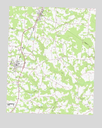
Elm City, NC USGS Topographic Map
Click on map above to begin viewing in our Map Viewer.

This topographic map contains these locations and features:
Feature Name Type Latitude Longitude GNIS ID View Map
Adams DamDamN35.7552°W77.8430°999354View Map
Adams PondReservoirN35.7546°W77.8448°999355View Map
Aenon ChurchChurchN35.8060°W77.7916°980060View Map
BridgersvillePopulated PlaceN35.7563°W77.7514°1006140View Map
Cattail BranchStreamN35.7596°W77.8075°982770View Map
Cattail SwampStreamN35.7863°W77.7766°982776View Map
Cedar Grove CemeteryCemeteryN35.8108°W77.8568°982831View Map
Cherrys ChapelChurchN35.8146°W77.7655°983093View Map
Cobbs CrossroadPopulated PlaceN35.8243°W77.8569°1019712View Map
Community ChurchChurchN35.7621°W77.7614°1024555View Map
Elm CityPopulated PlaceN35.8065°W77.8633°1020141View Map
Elm City Elementary SchoolSchoolN35.8068°W77.8715°1007003View Map
Elm City Emergency ServicesBuildingN35.8064°W77.8628°2720530View Map
Elm City Middle SchoolSchoolN35.8075°W77.8588°1007002View Map
Elm City Police DepartmentBuildingN35.8050°W77.8622°2130922View Map
Elm City Post OfficePost OfficeN35.8073°W77.8672°2773974View Map
Gospel Missionary ChurchChurchN35.8413°W77.8053°985863View Map
Little Union ChurchChurchN35.8024°W77.8358°988794View Map
New Hope ChurchChurchN35.7604°W77.7572°991012View Map
Oak Grove ChurchChurchN35.7929°W77.8175°991384View Map
Penders CrossroadsPopulated PlaceN35.7688°W77.7716°992020View Map
Peoples ChapelChurchN35.8277°W77.8628°992042View Map
Pleasant Hope ChurchChurchN35.7702°W77.8147°992551View Map
Putneys LakeReservoirN35.7835°W77.8664°999423View Map
Putneys Lake DamDamN35.7835°W77.8664°999424View Map
RosebudPopulated PlaceN35.7668°W77.8575°1006352View Map
SharpsburgPopulated PlaceN35.8671°W77.8291°994599View Map
Sharpsburg Fire Prevention Association Volunteer Fire Department Main StationBuildingN35.8698°W77.8299°2639353View Map
Sharpsburg Fire Prevention Association Volunteer Fire Department SubstationBuildingN35.8399°W77.8226°2639599View Map
Sharpsburg Police DepartmentBuildingN35.8668°W77.8290°2130860View Map
Sharpsburg Post OfficePost OfficeN35.8617°W77.8321°2774356View Map
Toisnot Rural Fire DepartmentBuildingN35.8064°W77.8625°2638352View Map
Town CreekPopulated PlaceN35.8152°W77.8011°1022972View Map
Town of Elm CityCivilN35.8088°W77.8622°2406443View Map
Town of SharpsburgCivilN35.8663°W77.8305°2407324View Map
Township 14-Upper Town CreekCivilN35.8671°W77.7774°1026671View Map
Township of ToisnotCivilN35.8098°W77.8308°1027350View Map
Upper Town Creek ChurchChurchN35.8152°W77.8003°996562View Map
Vaughn ChurchChurchN35.7674°W77.8358°996601View Map
White SwampStreamN35.7779°W77.7833°997220View Map
Wilson County Sheriff's OfficeBuildingN35.8051°W77.8621°2130917View Map

Note: Coordinates in the location and feature list above are referenced to NAD83 datum.


Copyright (C) 2008-2025 Ryan Niemi / Sunset Dynamics ... All Rights Reserved