TopoQuest Logo
Do you find TopoQuest useful?
Help keep TopoQuest running and adding new maps/features by donating!
Bitcoin:  19c7KJd3qBynnjoSw5npx9KScwjBe4ifkT
Litecoin:  LXs6TkuXGGXo1vDsWCkWVdjQX94eUKd6ui
Home View Maps Find Maps Find Places Resources & Links


Elmer, Missouri Topographic Map

USGS Map Title: Elmer, MO
USGS Map MRC: 39092H6
DRG (GeoTIFF) Download: o39092h6.tif


Neighboring USGS Topographic Map Quads:


  Nind, MO  
40092A7
 

  Gifford, MO  
40092A6
 

  Millard, MO  
40092A5
 

  New Boston, MO  
39092H7
 

  Elmer, MO  
39092H6
 

  Barnesville, MO  
39092H5
 

  New Cambria West, MO  
39092G7
 

  New Cambria East, MO  
39092G6
 

  Bevier North, MO  
39092G5


Map MRC Location:

N40°
W93°
N40°
W92°
H8 H7 H6 H5 H4 H3 H2 H1
G8 G7 G6 G5 G4 G3 G2 G1
F8 F7 F6 F5 F4 F3 F2 F1
E8 E7 E6 E5 E4 E3 E2 E1
D8 D7 D6 D5 D4 D3 D2 D1
C8 C7 C6 C5 C4 C3 C2 C1
B8 B7 B6 B5 B4 B3 B2 B1
A8 A7 A6 A5 A4 A3 A2 A1
N39°
W93°
N39°
W92°

Elmer, MO USGS 1:24K Topographic Map Preview:
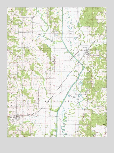
Elmer, MO USGS Topographic Map
Click on map above to begin viewing in our Map Viewer.

This topographic map contains these locations and features:
Feature Name Type Latitude Longitude GNIS ID View Map
Agee CemeteryCemeteryN39.9081°W92.6455°713168View Map
Agee LakeLakeN39.9114°W92.6630°713170View Map
Bell CemeteryCemeteryN39.9784°W92.6905°713905View Map
Bell SchoolSchoolN39.9870°W92.6910°741607View Map
Bone Yard LakeLakeN39.9148°W92.6655°714520View Map
Bunce CemeteryCemeteryN39.9475°W92.6913°715035View Map
Bunce SchoolSchoolN39.9386°W92.6941°741605View Map
City of ElmerCivilN39.9572°W92.6500°2394672View Map
Cottonwood CreekStreamN39.9814°W92.6607°716366View Map
Diamond SchoolSchoolN39.9828°W92.7188°741606View Map
Duck Hunters LakeLakeN39.9148°W92.6729°755477View Map
Ellison (historical)LocaleN39.9239°W92.6852°740179View Map
ElmerPopulated PlaceN39.9570°W92.6505°735597View Map
Elmer Post OfficePost OfficeN39.9576°W92.6506°2782746View Map
Elmer Rural Fire AssociationBuildingN39.9607°W92.6476°2621428View Map
EthelPopulated PlaceN39.8948°W92.7380°735601View Map
Ethel Post OfficePost OfficeN39.8943°W92.7404°2782718View Map
Ethel Volunteer Fire DepartmentBuildingN39.8943°W92.7399°2621753View Map
Fish LakeLakeN39.9803°W92.6721°717942View Map
Glasston CemeteryCemeteryN39.8953°W92.7121°718491View Map
Glasston SchoolSchoolN39.8970°W92.7119°741602View Map
Goff School (historical)SchoolN39.9367°W92.7202°741604View Map
Goodson CemeteryCemeteryN39.8861°W92.6271°718571View Map
Gunnels Landing Strip (historical)AirportN39.9745°W92.6721°741984View Map
Huckleberry CreekStreamN39.9417°W92.6541°719947View Map
Hull CemeteryCemeteryN39.8764°W92.6413°719984View Map
Little Turkey CreekStreamN39.8750°W92.6891°721345View Map
MercyvillePopulated PlaceN39.9717°W92.6432°741061View Map
Rock CreekStreamN39.9039°W92.6588°725446View Map
Rock Creek SchoolSchoolN39.8953°W92.6541°741603View Map
Round LakeLakeN39.9252°W92.6579°725605View Map
Sand CreekStreamN39.9673°W92.6563°726008View Map
Shirley CemeteryCemeteryN39.9595°W92.6396°726390View Map
Speno LakeLakeN39.9202°W92.6647°726856View Map
Star StoreLocaleN39.8870°W92.6599°740022View Map
Taylor HoleLakeN39.9688°W92.6639°727495View Map
Town of EthelCivilN39.8933°W92.7410°2396929View Map
Township of EasleyCivilN39.9993°W92.6789°766963View Map
Township of Walnut CreekCivilN39.9167°W92.6820°766980View Map
Turkey CreekStreamN39.8989°W92.6880°727852View Map
WalnutPopulated PlaceN39.9903°W92.7182°741346View Map
Walnut CreekStreamN39.9667°W92.6802°728300View Map

Note: Coordinates in the location and feature list above are referenced to NAD83 datum.


Copyright (C) 2008-2025 Ryan Niemi / Sunset Dynamics ... All Rights Reserved