TopoQuest Logo
Do you find TopoQuest useful?
Help keep TopoQuest running and adding new maps/features by donating!
Bitcoin:  19c7KJd3qBynnjoSw5npx9KScwjBe4ifkT
Litecoin:  LXs6TkuXGGXo1vDsWCkWVdjQX94eUKd6ui
Home View Maps Find Maps Find Places Resources & Links


Elmore City NE, Oklahoma Topographic Map

USGS Map Title: Elmore City NE, OK
USGS Map MRC: 34097F3
DRG (GeoTIFF) Download: o34097f3.tif


Neighboring USGS Topographic Map Quads:


  Maysville, OK  
34097G4
 

  Paoli, OK  
34097G3
 

  Byars SW, OK  
34097G2
 

  Elmore City North, OK  
34097F4
 

  Elmore City NE, OK  
34097F3
 

  Pauls Valley, OK  
34097F2
 

  Elmore City South, OK  
34097E4
 

  Hennepin, OK  
34097E3
 

  Joy, OK  
34097E2


Map MRC Location:

N35°
W98°
N35°
W97°
H8 H7 H6 H5 H4 H3 H2 H1
G8 G7 G6 G5 G4 G3 G2 G1
F8 F7 F6 F5 F4 F3 F2 F1
E8 E7 E6 E5 E4 E3 E2 E1
D8 D7 D6 D5 D4 D3 D2 D1
C8 C7 C6 C5 C4 C3 C2 C1
B8 B7 B6 B5 B4 B3 B2 B1
A8 A7 A6 A5 A4 A3 A2 A1
N34°
W98°
N34°
W97°

Elmore City NE, OK USGS 1:24K Topographic Map Preview:
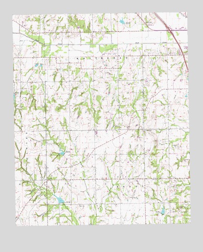
Elmore City NE, OK USGS Topographic Map
Click on map above to begin viewing in our Map Viewer.

This topographic map contains these locations and features:
Feature Name Type Latitude Longitude GNIS ID View Map
Fair Oak ChurchChurchN34.6523°W97.3520°1092686View Map
Garvin CountyCivilN34.7046°W97.3093°1101812View Map
Klondike CemeteryCemeteryN34.6710°W97.2594°1094417View Map
KVLH-AM (Pauls Valley)TowerN34.7042°W97.2556°1102213View Map
Love ChurchChurchN34.7115°W97.3709°1095021View Map
McCartyPopulated PlaceN34.6704°W97.3178°1763618View Map
Oknoname 04912 DamDamN34.7001°W97.2536°1758333View Map
Oknoname 04912 ReservoirReservoirN34.7001°W97.2536°1758334View Map
Oknoname 04922 DamDamN34.7434°W97.2953°1755655View Map
Oknoname 04922 ReservoirReservoirN34.7434°W97.2953°1755656View Map
Rush Creek Fire DepartmentBuildingN34.6886°W97.3350°2658696View Map
Rush Creek Site 37 and 39b DamDamN34.7234°W97.3570°1758364View Map
Rush Creek Site 37 and 39b ReservoirReservoirN34.7234°W97.3570°1758365View Map
Rush Creek Site 39c DamDamN34.7434°W97.2953°1758358View Map
Rush Creek Site 39c ReservoirReservoirN34.7434°W97.2953°1758359View Map
Shamley Gss Number 1 DamDamN34.7401°W97.3270°1751981View Map
Shamley Gss Number 1 ReservoirReservoirN34.7401°W97.3270°1751982View Map
Temple Gss Number 1 DamDamN34.6801°W97.3170°1753628View Map
Temple Gss Number 1 ReservoirReservoirN34.6801°W97.3170°1753629View Map
Valley Plaza Shopping CenterLocaleN34.7412°W97.2539°1778061View Map
Wildhorse Creek Site 118 DamDamN34.6384°W97.3420°1758291View Map
Wildhorse Creek Site 118 ReservoirReservoirN34.6384°W97.3420°1758292View Map
Wildhorse Creek Site 119 DamDamN34.6667°W97.3403°1758293View Map
Wildhorse Creek Site 119 ReservoirReservoirN34.6667°W97.3403°1758294View Map
Wildhorse Creek Site 57 DamDamN34.6317°W97.2703°1758253View Map
Wildhorse Creek Site 57 ReservoirReservoirN34.6317°W97.2703°1758254View Map

Note: Coordinates in the location and feature list above are referenced to NAD83 datum.


Copyright (C) 2008-2024 Ryan Niemi / Sunset Dynamics ... All Rights Reserved