TopoQuest Logo
Do you find TopoQuest useful?
Help keep TopoQuest running and adding new maps/features by donating!
Bitcoin:  19c7KJd3qBynnjoSw5npx9KScwjBe4ifkT
Litecoin:  LXs6TkuXGGXo1vDsWCkWVdjQX94eUKd6ui
Home View Maps Find Maps Find Places Resources & Links


Elwood, Indiana Topographic Map

USGS Map Title: Elwood, IN
USGS Map MRC: 40085C7
DRG (GeoTIFF) Download: o40085c7.tif


Neighboring USGS Topographic Map Quads:


  Greentown, IN  
40085D8
 

  Point Isabel, IN  
40085D7
 

  Fairmount, IN  
40085D6
 

  Windfall, IN  
40085C8
 

  Elwood, IN  
40085C7
 

  Alexandria, IN  
40085C6
 

  Omega, IN  
40085B8
 

  Frankton, IN  
40085B7
 

  Anderson North, IN  
40085B6


Map MRC Location:

N41°
W86°
N41°
W85°
H8 H7 H6 H5 H4 H3 H2 H1
G8 G7 G6 G5 G4 G3 G2 G1
F8 F7 F6 F5 F4 F3 F2 F1
E8 E7 E6 E5 E4 E3 E2 E1
D8 D7 D6 D5 D4 D3 D2 D1
C8 C7 C6 C5 C4 C3 C2 C1
B8 B7 B6 B5 B4 B3 B2 B1
A8 A7 A6 A5 A4 A3 A2 A1
N40°
W86°
N40°
W85°

Elwood, IN USGS 1:24K Topographic Map Preview:
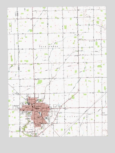
Elwood, IN USGS Topographic Map
Click on map above to begin viewing in our Map Viewer.

This topographic map contains these locations and features:
Feature Name Type Latitude Longitude GNIS ID View Map
Callaway ParkParkN40.2848°W85.8358°431967View Map
City of ElwoodCivilN40.2743°W85.8370°2394680View Map
College CornerPopulated PlaceN40.3059°W85.8419°432764View Map
Duck Creek CemeteryCemeteryN40.2603°W85.8553°432168View Map
Duck Creek Volunteer Fire DepartmentBuildingN40.3646°W85.8435°2626521View Map
DundeePopulated PlaceN40.2723°W85.7561°433774View Map
Edgewood Elementary SchoolSchoolN40.2856°W85.8378°434017View Map
ElwoodPopulated PlaceN40.2770°W85.8419°434144View Map
Elwood Airport (historical)AirportN40.2528°W85.8333°449154View Map
Elwood CemeteryCemeteryN40.2716°W85.8473°434145View Map
Elwood Country ClubLocaleN40.2537°W85.8444°452318View Map
Elwood Fire DepartmentBuildingN40.2747°W85.8400°2625693View Map
Elwood Junior High SchoolSchoolN40.2775°W85.8391°446039View Map
Elwood Police DepartmentBuildingN40.2747°W85.8410°2758471View Map
Haines DitchCanalN40.3728°W85.8525°435595View Map
Hoppenrath DitchCanalN40.3242°W85.8311°436471View Map
LeisurePopulated PlaceN40.3642°W85.8430°437764View Map
Lynwood SchoolSchoolN40.2684°W85.8375°438439View Map
McCluret DitchCanalN40.2545°W85.7980°438803View Map
Oakland Elementary SchoolSchoolN40.2628°W85.8330°440479View Map
Pipe Creek Township Volunteer Fire DepartmentBuildingN40.2771°W85.8032°2626015View Map
Red Corner SchoolSchoolN40.2770°W85.8033°441820View Map
Saint Joseph CemeteryCemeteryN40.2546°W85.8522°442632View Map
Saint Stephans ChurchChurchN40.2728°W85.8114°442841View Map
Saint Vincent Mercy HospitalHospitalN40.2756°W85.8438°439016View Map
Shay DitchCanalN40.3625°W85.8358°443325View Map
Shiloh ChurchChurchN40.2917°W85.7661°443402View Map
Smith DitchCanalN40.3478°W85.7819°443680View Map
South ElwoodPopulated PlaceN40.2625°W85.8422°443800View Map
Sunset Memorial ParkCemeteryN40.2572°W85.8432°444427View Map
Swanfelt DitchCanalN40.2687°W85.7769°444464View Map
Todd DitchCanalN40.3298°W85.8211°444797View Map
Township of Duck CreekCivilN40.3352°W85.8237°453267View Map
Union Valley ChurchChurchN40.3281°W85.7855°445135View Map
Washington Elementary SchoolSchoolN40.2784°W85.8530°445514View Map
Waymire CemeteryCemeteryN40.3061°W85.8180°445577View Map
WBMP-FM (Elwood)TowerN40.2767°W85.8611°449017View Map
West Drake DitchCanalN40.3648°W85.8236°445735View Map
West ElwoodPopulated PlaceN40.2798°W85.8605°445737View Map

Note: Coordinates in the location and feature list above are referenced to NAD83 datum.


Copyright (C) 2008-2025 Ryan Niemi / Sunset Dynamics ... All Rights Reserved