TopoQuest Logo
Do you find TopoQuest useful?
Help keep TopoQuest running and adding new maps/features by donating!
Bitcoin:  19c7KJd3qBynnjoSw5npx9KScwjBe4ifkT
Litecoin:  LXs6TkuXGGXo1vDsWCkWVdjQX94eUKd6ui
Home View Maps Find Maps Find Places Resources & Links


Elwood Canyon, Arizona Topographic Map

USGS Map Title: Elwood Canyon, AZ
USGS Map MRC: 33109E8
DRG (GeoTIFF) Download: o33109e8.tif


Neighboring USGS Topographic Map Quads:


  Velasquez Butte, AZ  
33110F1
 

  Bonito Prairie, AZ  
33109F8
 

  Corn Creek, AZ  
33109F7
 

  Georges Butte, AZ  
33110E1
 

  Elwood Canyon, AZ  
33109E8
 

  West Poker Mountain, AZ  
33109E7
 

  Ash Creek NE, AZ  
33110D1
 

  Natanes Mountains NW, AZ  
33109D8
 

  Natanes Mountains NE, AZ  
33109D7


Map MRC Location:

N34°
W110°
N34°
W109°
H8 H7 H6 H5 H4 H3 H2 H1
G8 G7 G6 G5 G4 G3 G2 G1
F8 F7 F6 F5 F4 F3 F2 F1
E8 E7 E6 E5 E4 E3 E2 E1
D8 D7 D6 D5 D4 D3 D2 D1
C8 C7 C6 C5 C4 C3 C2 C1
B8 B7 B6 B5 B4 B3 B2 B1
A8 A7 A6 A5 A4 A3 A2 A1
N33°
W110°
N33°
W109°

Elwood Canyon, AZ USGS 1:24K Topographic Map Preview:
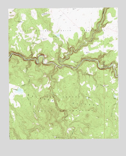
Elwood Canyon, AZ USGS Topographic Map
Click on map above to begin viewing in our Map Viewer.

This topographic map contains these locations and features:
Feature Name Type Latitude Longitude GNIS ID View Map
Big Bonito CreekStreamN33.5709°W109.9379°26241View Map
Bloody Basin CanyonValleyN33.5762°W109.9759°1688View Map
Bloody Basin DamDamN33.5487°W109.9868°22417View Map
Bloody Basin TankReservoirN33.5474°W109.9875°1689View Map
Elwood CanyonValleyN33.5673°W109.9231°4423View Map
Elwood CreekStreamN33.5673°W109.9237°22486View Map
Elwood DamDamN33.5423°W109.8798°22487View Map
Elwood TankReservoirN33.5404°W109.8793°4424View Map
Elwood WindmillLocaleN33.5503°W109.8918°4425View Map
Grass Flat TankReservoirN33.5824°W109.9126°5296View Map
Hookers Gap DamDamN33.5401°W109.9629°22527View Map
Lower Grass Flat TankReservoirN33.5737°W109.9267°7468View Map
Mud Spring CanyonValleyN33.5770°W109.9754°8374View Map
Mud Spring TankReservoirN33.5959°W109.9619°8376View Map
Mudhole TankReservoirN33.5391°W109.9109°8400View Map
Natanes PlateauPlainN33.5348°W109.9387°8504View Map
Prairie Pit TankReservoirN33.6231°W109.9276°9752View Map
Rocky Basin Tank Number OneReservoirN33.6192°W109.9608°10450View Map
Rocky Basin Tank Number TwoReservoirN33.6122°W109.9839°10451View Map
Sawmill CanyonValleyN33.5706°W109.9451°10977View Map
Sawmill CreekStreamN33.5703°W109.9454°10980View Map
Turkey CreekStreamN33.5814°W109.9970°12867View Map
Weaning Pen TankReservoirN33.5994°W109.9435°13411View Map
Willow CreekStreamN33.5689°W109.8809°13830View Map

Note: Coordinates in the location and feature list above are referenced to NAD83 datum.


Copyright (C) 2008-2025 Ryan Niemi / Sunset Dynamics ... All Rights Reserved