TopoQuest Logo
Do you find TopoQuest useful?
Help keep TopoQuest running and adding new maps/features by donating!
Bitcoin:  19c7KJd3qBynnjoSw5npx9KScwjBe4ifkT
Litecoin:  LXs6TkuXGGXo1vDsWCkWVdjQX94eUKd6ui
Home View Maps Find Maps Find Places Resources & Links


Emerson, Arkansas Topographic Map

USGS Map Title: Emerson, AR
USGS Map MRC: 33093A2
DRG (GeoTIFF) Download: o33093a2.tif


Neighboring USGS Topographic Map Quads:


  Macedonia, AR  
33093B3
 

  Calhoun, AR  
33093B2
 

  Spotville, AR  
33093B1
 

  Walkerville, AR  
33093A3
 

  Emerson, AR  
33093A2
 

  Emerson SE, AR  
33093A1
 

  Shongaloo, LA  
32093H3
 

  Haynesville West, LA  
32093H2
 

  Haynesville East, LA  
32093H1


Map MRC Location:

N34°
W94°
N34°
W93°
H8 H7 H6 H5 H4 H3 H2 H1
G8 G7 G6 G5 G4 G3 G2 G1
F8 F7 F6 F5 F4 F3 F2 F1
E8 E7 E6 E5 E4 E3 E2 E1
D8 D7 D6 D5 D4 D3 D2 D1
C8 C7 C6 C5 C4 C3 C2 C1
B8 B7 B6 B5 B4 B3 B2 B1
A8 A7 A6 A5 A4 A3 A2 A1
N33°
W94°
N33°
W93°

Emerson, AR USGS 1:24K Topographic Map Preview:
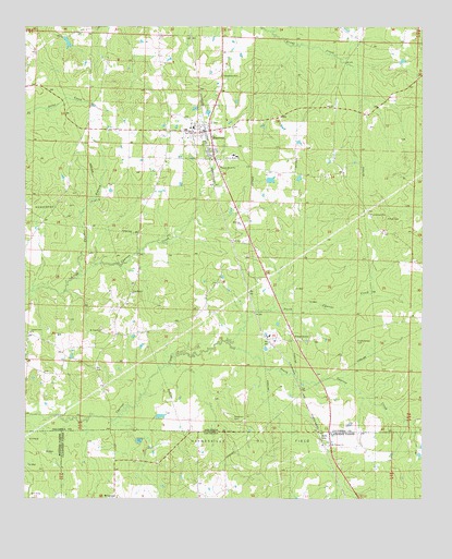
Emerson, AR USGS Topographic Map
Click on map above to begin viewing in our Map Viewer.

This topographic map contains these locations and features:
Feature Name Type Latitude Longitude GNIS ID View Map
Anderson CemeteryCemeteryN33.0212°W93.1840°45862View Map
Canaan Land ChurchChurchN33.0443°W93.2479°47365View Map
Cross Roads Church (historical)ChurchN33.0979°W93.2310°60250View Map
Elliott CemeteryCemeteryN33.0740°W93.1363°48857View Map
EmersonPopulated PlaceN33.0976°W93.1929°48887View Map
Emerson ChurchChurchN33.0729°W93.1818°48889View Map
Emerson Elementary SchoolSchoolN33.0979°W93.1995°60251View Map
Emerson High SchoolSchoolN33.0989°W93.1969°60252View Map
Emerson Volunteer Fire DepartmentBuildingN33.0990°W93.1918°2116403View Map
Forest GrovePopulated PlaceN33.0424°W93.1646°57761View Map
Forest Grove CemeteryCemeteryN33.0415°W93.1460°49164View Map
Forest Grove ChurchChurchN33.0424°W93.1632°60255View Map
Haynesville Oil FieldOilfieldN33.0199°W93.1735°49964View Map
Hopewell School (historical)SchoolN33.0207°W93.1985°60259View Map
Horsehead Oil FieldOilfieldN33.0785°W93.2371°50333View Map
MillertonPopulated PlaceN33.0004°W93.2216°543473View Map
MohawkPopulated PlaceN33.0682°W93.1852°60253View Map
Mount Pisgah United Methodist ChurchChurchN33.0449°W93.2254°77732View Map
Mount Pleasant ChurchChurchN33.0143°W93.1543°537397View Map
Mount Pleasant School (historical)SchoolN33.0140°W93.1543°540780View Map
North Cypress CreekStreamN33.0421°W93.1868°52815View Map
Panther BranchStreamN33.0596°W93.2327°53146View Map
Pine Hill ChurchChurchN33.0546°W93.2160°53436View Map
Pisgah School (historical)SchoolN33.0368°W93.2343°60249View Map
Pleasant Home ChurchChurchN33.0882°W93.1885°53577View Map
Providence CemeteryCemeteryN33.0754°W93.1424°53820View Map
Providence Church (historical)ChurchN33.0751°W93.1418°60257View Map
Rucks SpurLocaleN33.0432°W93.1749°60254View Map
Sale LakeReservoirN33.1209°W93.2370°80455View Map
Sale Lake DamDamN33.1218°W93.2368°80454View Map
SocoPopulated PlaceN33.0029°W93.1474°540781View Map
South Cypress CreekStreamN33.0421°W93.1868°78406View Map
State LineLocaleN33.0162°W93.1571°556141View Map
State Line School (historical)SchoolN33.0182°W93.1543°60256View Map
Sweet Home ChurchChurchN33.0901°W93.1866°55385View Map
Town of EmersonCivilN33.0973°W93.1959°2406449View Map
Township of EmersonCivilN33.0880°W93.1684°63749View Map
Township of Moss (historical)CivilN33.0807°W93.1807°59969View Map
Wood School (historical)SchoolN33.1040°W93.1529°60258View Map

Note: Coordinates in the location and feature list above are referenced to NAD83 datum.


Copyright (C) 2008-2025 Ryan Niemi / Sunset Dynamics ... All Rights Reserved