TopoQuest Logo
Do you find TopoQuest useful?
Help keep TopoQuest running and adding new maps/features by donating!
Bitcoin:  19c7KJd3qBynnjoSw5npx9KScwjBe4ifkT
Litecoin:  LXs6TkuXGGXo1vDsWCkWVdjQX94eUKd6ui
Home View Maps Find Maps Find Places Resources & Links


Eskridge, Kansas Topographic Map

USGS Map Title: Eskridge, KS
USGS Map MRC: 38096G1
DRG (GeoTIFF) Download: o38096g1.tif


Neighboring USGS Topographic Map Quads:


  Hessdale, KS  
38096H2
 

  Keene, KS  
38096H1
 

  Dover, KS  
38095H8
 

  Lake Wabaunsee, KS  
38096G2
 

  Eskridge, KS  
38096G1
 

  Harveyville, KS  
38095G8
 

  Allen, KS  
38096F2
 

  Admire, KS  
38096F1
 

  Miller, KS  
38095F8


Map MRC Location:

N39°
W97°
N39°
W96°
H8 H7 H6 H5 H4 H3 H2 H1
G8 G7 G6 G5 G4 G3 G2 G1
F8 F7 F6 F5 F4 F3 F2 F1
E8 E7 E6 E5 E4 E3 E2 E1
D8 D7 D6 D5 D4 D3 D2 D1
C8 C7 C6 C5 C4 C3 C2 C1
B8 B7 B6 B5 B4 B3 B2 B1
A8 A7 A6 A5 A4 A3 A2 A1
N38°
W97°
N38°
W96°

Eskridge, KS USGS 1:24K Topographic Map Preview:
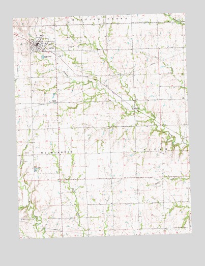
Eskridge, KS USGS Topographic Map
Click on map above to begin viewing in our Map Viewer.

This topographic map contains these locations and features:
Feature Name Type Latitude Longitude GNIS ID View Map
American Medical Response EskridgeBuildingN38.8608°W96.1077°2696571View Map
BradfordPopulated PlaceN38.8217°W96.0392°484796View Map
City of EskridgeCivilN38.8595°W96.1046°2394701View Map
EskridgePopulated PlaceN38.8589°W96.1092°476925View Map
Eskridge CemeteryCemeteryN38.8579°W96.0850°476926View Map
Eskridge City HallBuildingN38.8599°W96.1075°2693046View Map
Eskridge Police DepartmentBuildingN38.8599°W96.1076°2504205View Map
Eskridge Post OfficePost OfficeN38.8595°W96.1079°2693713View Map
Eskridge Senior CenterBuildingN38.8591°W96.1081°2692606View Map
Eskridge Southern Baptist ChurchChurchN38.8600°W96.1021°2690720View Map
Eskridge United Methodist ChurchChurchN38.8581°W96.1083°2689408View Map
Eskridge Wastewater Treatment PlantLocaleN38.8526°W96.1041°2692151View Map
First United Presbyterian ChurchChurchN38.8589°W96.1075°2690589View Map
Hungry HollowValleyN38.7822°W96.1238°476928View Map
Locust CreekStreamN38.7678°W96.1164°476923View Map
Mission Valley High SchoolSchoolN38.8575°W96.1036°480942View Map
Mission Valley School District OfficeSchoolN38.8574°W96.1037°480943View Map
Pottawatomie Wabaunsee Regional Library Eskridge BranchBuildingN38.8600°W96.1081°2694869View Map
Township of WilmingtonCivilN38.8002°W96.1112°476927View Map
Wabaunsee County Fire District 5BuildingN38.8607°W96.1075°2111951View Map

Note: Coordinates in the location and feature list above are referenced to NAD83 datum.


Copyright (C) 2008-2025 Ryan Niemi / Sunset Dynamics ... All Rights Reserved