TopoQuest Logo
Do you find TopoQuest useful?
Help keep TopoQuest running and adding new maps/features by donating!
Bitcoin:  19c7KJd3qBynnjoSw5npx9KScwjBe4ifkT
Litecoin:  LXs6TkuXGGXo1vDsWCkWVdjQX94eUKd6ui
Home View Maps Find Maps Find Places Resources & Links


Esterbrook, Wyoming Topographic Map

USGS Map Title: Esterbrook, WY
USGS Map MRC: 42105D3
DRG (GeoTIFF) Download: o42105d3.tif


Neighboring USGS Topographic Map Quads:


  Poison Lake, WY  
42105E4
 

  Dilts Ranch, WY  
42105E3
 

  Cedar Hill, WY  
42105E2
 

  Braae, WY  
42105D4
 

  Esterbrook, WY  
42105D3
 

  Spring Creek, WY  
42105D2
 

  Laramie Peak, WY  
42105C4
 

  Harris Park, WY  
42105C3
 

  Cottonwood Falls, WY  
42105C2


Map MRC Location:

N43°
W106°
N43°
W105°
H8 H7 H6 H5 H4 H3 H2 H1
G8 G7 G6 G5 G4 G3 G2 G1
F8 F7 F6 F5 F4 F3 F2 F1
E8 E7 E6 E5 E4 E3 E2 E1
D8 D7 D6 D5 D4 D3 D2 D1
C8 C7 C6 C5 C4 C3 C2 C1
B8 B7 B6 B5 B4 B3 B2 B1
A8 A7 A6 A5 A4 A3 A2 A1
N42°
W106°
N42°
W105°

Esterbrook, WY USGS 1:24K Topographic Map Preview:
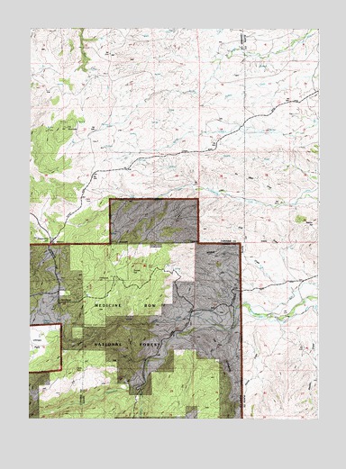
Esterbrook, WY USGS Topographic Map
Click on map above to begin viewing in our Map Viewer.

This topographic map contains these locations and features:
Feature Name Type Latitude Longitude GNIS ID View Map
Castle RockSummitN42.3900°W105.3542°1598665View Map
Cooper SpringSpringN42.4059°W105.3662°1598895View Map
Day DrawValleyN42.4008°W105.3483°1599137View Map
Elk MountainSummitN42.4683°W105.3572°1599589View Map
EsterbrookPopulated PlaceN42.4116°W105.3608°1599634View Map
Esterbrook CampgroundLocaleN42.4241°W105.3233°1605050View Map
Esterbrook HillSummitN42.4197°W105.3455°1599635View Map
Esterbrook Work CenterLocaleN42.4161°W105.3614°1605049View Map
Fred Dilts Number 4 DamDamN42.4650°W105.3355°1609006View Map
Fred Dilts Reservoir Number 4ReservoirN42.4650°W105.3355°1609007View Map
Horse DrawValleyN42.4039°W105.2766°1600417View Map
Macfarlane RanchLocaleN42.4080°W105.2705°1601216View Map
Norcross Family CemeteryCemeteryN42.4289°W105.3628°2774550View Map
Prairie Dog HillSummitN42.4314°W105.3644°1602300View Map
Reeder HillSummitN42.4369°W105.2589°1602477View Map
Soldier CreekStreamN42.3847°W105.3242°1603067View Map
Sunset HillSummitN42.4250°W105.3289°1603450View Map
The LimestoneSummitN42.3975°W105.2969°1603603View Map
Three Cripples CreekStreamN42.4044°W105.2939°1603653View Map
Wildcat DrawValleyN42.4155°W105.2605°1604174View Map

Note: Coordinates in the location and feature list above are referenced to NAD83 datum.


Copyright (C) 2008-2025 Ryan Niemi / Sunset Dynamics ... All Rights Reserved