TopoQuest Logo
Do you find TopoQuest useful?
Help keep TopoQuest running and adding new maps/features by donating!
Bitcoin:  19c7KJd3qBynnjoSw5npx9KScwjBe4ifkT
Litecoin:  LXs6TkuXGGXo1vDsWCkWVdjQX94eUKd6ui
Home View Maps Find Maps Find Places Resources & Links


Estill Fork, Alabama Topographic Map

USGS Map Title: Estill Fork, AL
USGS Map MRC: 34086H2
DRG (GeoTIFF) Download: o34086h2.tif


Neighboring USGS Topographic Map Quads:


  Huntland, TN  
35086A3
 

  Beans Creek, TN  
35086A2
 

  Pitcher Ridge, TN  
35086A1
 

  King Cove, AL  
34086H3
 

  Estill Fork, AL  
34086H2
 

  Hytop, AL  
34086H1
 

  Hollytree, AL  
34086G3
 

  Princeton, AL  
34086G2
 

  Mud Creek, AL  
34086G1


Map MRC Location:

N35°
W87°
N35°
W86°
H8 H7 H6 H5 H4 H3 H2 H1
G8 G7 G6 G5 G4 G3 G2 G1
F8 F7 F6 F5 F4 F3 F2 F1
E8 E7 E6 E5 E4 E3 E2 E1
D8 D7 D6 D5 D4 D3 D2 D1
C8 C7 C6 C5 C4 C3 C2 C1
B8 B7 B6 B5 B4 B3 B2 B1
A8 A7 A6 A5 A4 A3 A2 A1
N34°
W87°
N34°
W86°

Estill Fork, AL USGS 1:24K Topographic Map Preview:
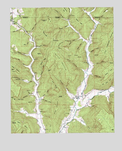
Estill Fork, AL USGS Topographic Map
Click on map above to begin viewing in our Map Viewer.

This topographic map contains these locations and features:
Feature Name Type Latitude Longitude GNIS ID View Map
Anderson CemeteryCemeteryN34.9037°W86.1528°113073View Map
Anderson HollowValleyN34.9023°W86.1569°113074View Map
Backbone RidgeRidgeN34.9473°W86.2108°113331View Map
Bear CreekStreamN34.9423°W86.2255°113668View Map
Beaver BranchStreamN34.9662°W86.2225°113712View Map
Beech Grove ChurchChurchN34.9851°W86.2469°113819View Map
Beech Grove Methodist ChurchChurchN34.9884°W86.2497°1959033View Map
Beech Grove School (historical)SchoolN34.9904°W86.2497°1700325View Map
Bishop CemeteryCemeteryN34.9112°W86.1308°114380View Map
Bishop CoveValleyN34.9129°W86.1353°114381View Map
Bishop SpringSpringN34.9126°W86.1305°114388View Map
Bostick Hill ChurchChurchN34.8970°W86.1761°114748View Map
Bouldin CemeteryCemeteryN34.8809°W86.1833°114763View Map
Bradford RidgeRidgeN34.9851°W86.1669°114810View Map
Brewer MountainSummitN34.8990°W86.1930°114869View Map
Bucky SinkBasinN34.9390°W86.2492°115150View Map
Buddy TopSummitN34.9062°W86.2300°115152View Map
Bull RunStreamN34.9908°W86.1531°115183View Map
Bull RunStreamN34.9909°W86.1533°1278955View Map
Burks CreekStreamN34.9614°W86.1550°115233View Map
Butler CemeteryCemeteryN34.8987°W86.2147°115313View Map
Chapel Hill School (historical)SchoolN34.9676°W86.1583°1959036View Map
Cold Spring BenchBenchN34.9237°W86.1361°116392View Map
Collins CemeteryCemeteryN34.9123°W86.1611°116442View Map
Crawford CemeteryCemeteryN34.9209°W86.1264°116826View Map
Deer Lick BluffCliffN34.9634°W86.1894°117199View Map
Doctor KnobSummitN34.9373°W86.1280°117331View Map
Dodson CoveValleyN34.9944°W86.1772°1282569View Map
Duboise HollowValleyN34.9737°W86.2266°117607View Map
Earwood HollowValleyN34.9820°W86.1789°117731View Map
Erwin HollowValleyN34.9101°W86.2153°118023View Map
Estill ForkStreamN34.8981°W86.1706°118042View Map
EstillforkPopulated PlaceN34.9101°W86.1705°156322View Map
Fanning CemeteryCemeteryN34.9370°W86.2483°118193View Map
Fanning CoveValleyN34.9276°W86.2230°118194View Map
Fanning HollowValleyN34.9695°W86.1650°118195View Map
Fanning Low GapGapN34.8868°W86.2486°118196View Map
FranciscoPopulated PlaceN34.9873°W86.2492°156378View Map
Freedom BridgeBridgeN34.9104°W86.1680°118619View Map
Freedom ChurchChurchN34.9106°W86.1675°1959041View Map
Freedom School (historical)SchoolN34.9106°W86.1672°1700330View Map
Gifford HollowValleyN34.9662°W86.1605°118936View Map
Granny BranchStreamN34.9881°W86.2500°119233View Map
Grays ChapelChurchN34.9451°W86.1567°119304View Map
Grays ChapelChurchN34.9662°W86.1555°154456View Map
Grays Chapel Church (historical)ChurchN34.9734°W86.1505°139173View Map
Grays Chapel School (historical)SchoolN34.9693°W86.1528°139174View Map
Halls ChapelChurchN34.9087°W86.2142°119593View Map
Hard SinkBasinN34.9101°W86.2450°119710View Map
Henshaw CemeteryCemeteryN34.8879°W86.1830°119979View Map
Henshaw CoveValleyN34.8895°W86.1736°119980View Map
Hodge MountainSummitN34.9370°W86.2428°120170View Map
Hogyard RidgeRidgeN34.9729°W86.2089°120216View Map
Holland CoveValleyN34.9068°W86.1722°120239View Map
Honey HollowValleyN34.9872°W86.1800°120325View Map
Houston HollowValleyN34.9340°W86.1536°120464View Map
Hurricane CreekStreamN34.8981°W86.1703°154464View Map
Jack CemeteryCemeteryN34.9267°W86.2269°120744View Map
Kennedy HollowValleyN34.9595°W86.2203°121154View Map
Langham HollowValleyN34.9554°W86.1553°121385View Map
LarkinPopulated PlaceN34.9095°W86.2153°156582View Map
Larkin MountainSummitN34.9293°W86.2017°121397View Map
Larkin SpringSpringN34.9941°W86.2493°1290646View Map
Larkin Spring BranchStreamN34.9879°W86.2500°1290647View Map
Little Cumberland MountainSummitN34.9615°W86.1319°121775View Map
Low GapGapN34.9518°W86.1728°122073View Map
Maxwell MountainSummitN34.8779°W86.2278°122411View Map
McCullough CemeteryCemeteryN34.9176°W86.1405°122510View Map
Milan (historical)Populated PlaceN34.9104°W86.1672°139218View Map
Mill HollowValleyN34.9850°W86.1437°122806View Map
Mill Seat SpringSpringN34.9100°W86.2473°122812View Map
Miller CemeteryCemeteryN34.9595°W86.1916°122826View Map
Miller MountainSummitN34.9462°W86.1886°122831View Map
Moores CoveBasinN34.9962°W86.1331°123025View Map
Newby HollowValleyN34.9804°W86.2364°123925View Map
Oakley Church (historical)ChurchN34.9404°W86.2244°139241View Map
Oakley School (historical)SchoolN34.9465°W86.2222°1959056View Map
Old Bostick Hill CemeteryCemeteryN34.8945°W86.1791°124201View Map
Old Grays CemeteryCemeteryN34.9740°W86.1503°149583View Map
Opossum HollowValleyN34.9853°W86.2420°124294View Map
Parks HollowValleyN34.9134°W86.2275°124455View Map
Pigeon CreekStreamN34.9870°W86.2497°124714View Map
Poplar SpringSpringN34.8781°W86.1285°125156View Map
Posey CemeteryCemeteryN34.9917°W86.2064°1298284View Map
Prince CemeteryCemeteryN34.8967°W86.2200°125284View Map
Prince CemeteryCemeteryN34.9181°W86.1466°125285View Map
Prince PointCapeN34.8759°W86.2019°125286View Map
Puncheon CoveValleyN34.9534°W86.2280°125364View Map
Puncheon CreekStreamN34.9531°W86.2272°139254View Map
Putman SpringSpringN34.9919°W86.1778°1298718View Map
Reid CemeteryCemeteryN34.9120°W86.1728°125555View Map
Reid CoveValleyN34.8890°W86.2197°153134View Map
Reid HollowValleyN34.9356°W86.1597°153135View Map
Reid Hollow CreekStreamN34.9354°W86.1597°149587View Map
Rich HollowValleyN34.9087°W86.2161°125601View Map
Round MountainSummitN34.9543°W86.2180°125981View Map
Sheep BluffCliffN34.9181°W86.2286°126661View Map
Shepard HollowValleyN34.9140°W86.2228°126689View Map
Shooting Ground HollowValleyN34.9881°W86.2122°126801View Map
Simpson HollowValleyN34.9270°W86.2180°126876View Map
Sisk CemeteryCemeteryN34.9667°W86.1528°126907View Map
Sisk GapGapN34.9443°W86.1255°126908View Map
Sisk PointCapeN34.9520°W86.1428°126909View Map
Skillet HandleSummitN34.9087°W86.2417°126931View Map
Slick Rock HollowValleyN34.9659°W86.1753°126971View Map
Suck BranchStreamN34.9826°W86.1778°127494View Map
Swaim CemeteryCemeteryN34.9101°W86.1722°127575View Map
The KnobSummitN34.9504°W86.1694°127817View Map
The NarrowsGapN34.9676°W86.1980°155924View Map
Trice HollowValleyN34.9420°W86.1508°128069View Map
Turley CemeteryCemeteryN34.9523°W86.1803°128182View Map
Valley Volunteer Fire Department Station 3BuildingN34.9215°W86.1656°2683230View Map
Vandiver Low GapGapN34.9118°W86.1925°128411View Map
Walnut GapGapN34.9373°W86.2050°128551View Map
Wilson CemeteryCemeteryN34.9881°W86.1808°129076View Map
Wilson TopSummitN34.9895°W86.2028°129099View Map

Note: Coordinates in the location and feature list above are referenced to NAD83 datum.


Copyright (C) 2008-2024 Ryan Niemi / Sunset Dynamics ... All Rights Reserved