TopoQuest Logo
Do you find TopoQuest useful?
Help keep TopoQuest running and adding new maps/features by donating!
Bitcoin:  19c7KJd3qBynnjoSw5npx9KScwjBe4ifkT
Litecoin:  LXs6TkuXGGXo1vDsWCkWVdjQX94eUKd6ui
Home View Maps Find Maps Find Places Resources & Links


Estrella, California Topographic Map

USGS Map Title: Estrella, CA
USGS Map MRC: 35120F5
DRG (GeoTIFF) Download: o35120f5.tif


Neighboring USGS Topographic Map Quads:


  San Miguel, CA  
35120G6
 

  Ranchito Canyon, CA  
35120G5
 

  Cholame Hills, CA  
35120G4
 

  Paso Robles, CA  
35120F6
 

  Estrella, CA  
35120F5
 

  Shandon, CA  
35120F4
 

  Templeton, CA  
35120E6
 

  Creston, CA  
35120E5
 

  Shedd Canyon, CA  
35120E4


Map MRC Location:

N36°
W121°
N36°
W120°
H8 H7 H6 H5 H4 H3 H2 H1
G8 G7 G6 G5 G4 G3 G2 G1
F8 F7 F6 F5 F4 F3 F2 F1
E8 E7 E6 E5 E4 E3 E2 E1
D8 D7 D6 D5 D4 D3 D2 D1
C8 C7 C6 C5 C4 C3 C2 C1
B8 B7 B6 B5 B4 B3 B2 B1
A8 A7 A6 A5 A4 A3 A2 A1
N35°
W121°
N35°
W120°

Estrella, CA USGS 1:24K Topographic Map Preview:
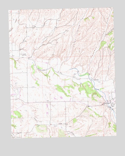
Estrella, CA USGS Topographic Map
Click on map above to begin viewing in our Map Viewer.

This topographic map contains these locations and features:
Feature Name Type Latitude Longitude GNIS ID View Map
Arciero WineryLocaleN35.6569°W120.5902°1872177View Map
Baron VineyardsLocaleN35.6291°W120.6152°1872179View Map
BernPopulated PlaceN35.6891°W120.5396°1667662View Map
Bonel AirportAirportN35.6728°W120.5459°1654117View Map
California Department of Forestry and Fire Protection Station 52 MeridianBuildingN35.6606°W120.5785°2664814View Map
Clarke CanyonValleyN35.6702°W120.5199°240669View Map
Dry Creek School (historical)SchoolN35.6450°W120.6135°1667664View Map
EstrellaPopulated PlaceN35.7055°W120.6102°1656509View Map
Estrella River WineryLocaleN35.6611°W120.5902°1872186View Map
Fifteenmile BridgeBridgeN35.6530°W120.5079°1667667View Map
Hillman RanchLocaleN35.6800°W120.5260°243474View Map
Hog CanyonValleyN35.7033°W120.6027°243512View Map
Keyes CanyonValleyN35.6961°W120.5677°244289View Map
Keyes School (historical)SchoolN35.7316°W120.5482°1667673View Map
Mason CanyonValleyN35.6872°W120.5332°252429View Map
Paso Robles DivisionCivilN35.6410°W120.5436°1935246View Map
Paso Robles LandfillLocaleN35.6622°W120.5317°2726495View Map
Phillips Freedom Community SchoolSchoolN35.6543°W120.5057°247428View Map
Phillips School (historical)SchoolN35.6833°W120.5513°1667679View Map
Pine CreekStreamN35.6541°W120.5091°247496View Map
Pleasant Valley SchoolSchoolN35.7112°W120.6133°247611View Map
Ranchito School (historical)SchoolN35.7466°W120.6135°1667681View Map
Sheep Camp CanyonValleyN35.6736°W120.5249°249358View Map
UnionPopulated PlaceN35.6375°W120.5610°1667686View Map
Union SchoolSchoolN35.6383°W120.5654°250808View Map
Whitley GardensPopulated PlaceN35.6591°W120.5077°1656657View Map
Whitley Gardens Census Designated PlaceCensusN35.6572°W120.5069°2583185View Map
Wild Horse CanyonValleyN35.7222°W120.5124°238379View Map

Note: Coordinates in the location and feature list above are referenced to NAD83 datum.


Copyright (C) 2008-2025 Ryan Niemi / Sunset Dynamics ... All Rights Reserved