TopoQuest Logo
Do you find TopoQuest useful?
Help keep TopoQuest running and adding new maps/features by donating!
Bitcoin:  19c7KJd3qBynnjoSw5npx9KScwjBe4ifkT
Litecoin:  LXs6TkuXGGXo1vDsWCkWVdjQX94eUKd6ui
Home View Maps Find Maps Find Places Resources & Links


Evans City, Pennsylvania Topographic Map

USGS Map Title: Evans City, PA
USGS Map MRC: 40080G1
DRG (GeoTIFF) Download: o40080g1.tif


Neighboring USGS Topographic Map Quads:


  Portersville, PA  
40080H2
 

  Prospect, PA  
40080H1
 

  Mount Chestnut, PA  
40079H8
 

  Zelienople, PA  
40080G2
 

  Evans City, PA  
40080G1
 

  Butler, PA  
40079G8
 

  Baden, PA  
40080F2
 

  Mars, PA  
40080F1
 

  Valencia, PA  
40079F8


Map MRC Location:

N41°
W81°
N41°
W80°
H8 H7 H6 H5 H4 H3 H2 H1
G8 G7 G6 G5 G4 G3 G2 G1
F8 F7 F6 F5 F4 F3 F2 F1
E8 E7 E6 E5 E4 E3 E2 E1
D8 D7 D6 D5 D4 D3 D2 D1
C8 C7 C6 C5 C4 C3 C2 C1
B8 B7 B6 B5 B4 B3 B2 B1
A8 A7 A6 A5 A4 A3 A2 A1
N40°
W81°
N40°
W80°

Evans City, PA USGS 1:24K Topographic Map Preview:
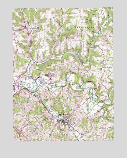
Evans City, PA USGS Topographic Map
Click on map above to begin viewing in our Map Viewer.

This topographic map contains these locations and features:
Feature Name Type Latitude Longitude GNIS ID View Map
Bloomfield SchoolSchoolN40.8351°W80.0806°1197733View Map
Borough of ConnoquenessingCivilN40.8174°W80.0152°1214989View Map
Borough of Evans CityCivilN40.7685°W80.0584°1214992View Map
Breakneck CreekStreamN40.7976°W80.0978°1170184View Map
Brennan Personal Use AirportAirportN40.8553°W80.0691°1197867View Map
Buhls StationPopulated PlaceN40.7987°W80.0256°1170630View Map
Carr Post Office (historical)Post OfficeN40.7584°W80.0317°1214280View Map
ConnoquenessingPopulated PlaceN40.8178°W80.0142°1172353View Map
Connoquenessing Post OfficePost OfficeN40.8173°W80.0143°2431864View Map
Connoquenessing Volunteer Fire Company Station 12BuildingN40.8173°W80.0147°2645631View Map
Crab RunStreamN40.8287°W80.0714°1172577View Map
EidenauPopulated PlaceN40.7917°W80.0959°1174055View Map
Eldenau Post Office (historical)Post OfficeN40.7695°W80.0623°1214279View Map
Evans CityPopulated PlaceN40.7692°W80.0628°1174344View Map
Evans City Area Volunteer Fire Department - Station 20BuildingN40.7702°W80.0616°2645615View Map
Evans City CemeteryCemeteryN40.7619°W80.0637°1174345View Map
Evans City Elementary SchoolSchoolN40.7698°W80.0698°1211469View Map
Evans City Post OfficePost OfficeN40.7687°W80.0615°2431880View Map
Evansburg Dam Number TwoDamN40.7667°W80.0914°1195022View Map
Evansburg ReservoirReservoirN40.7701°W80.0864°1195027View Map
Evansburg Reservoir Number TwoReservoirN40.7682°W80.0888°1195023View Map
Glade RunStreamN40.7842°W80.0203°1175660View Map
Harmony JunctionPopulated PlaceN40.7962°W80.1031°1176558View Map
Hartmanns Deep Valley Golf CourseLocaleN40.8048°W80.0998°1206297View Map
Hazel Dell SchoolSchoolN40.8648°W80.0781°1206055View Map
Jackson Township Police DepartmentBuildingN40.7929°W80.1047°2775175View Map
Likens RunStreamN40.7740°W80.0726°1179333View Map
Little Connoquenessing CreekStreamN40.7995°W80.1067°1179509View Map
Little Yellow CreekStreamN40.8548°W80.0987°1179718View Map
Martin SchoolSchoolN40.8692°W80.0173°1197732View Map
Middle LancasterPopulated PlaceN40.8545°W80.1234°1198292View Map
Mount Nebb CemeteryCemeteryN40.8636°W80.0334°1181753View Map
Mulligan RunStreamN40.8659°W80.0039°1192997View Map
Pabst Blue Ribbon AirportAirportN40.7602°W80.0131°1194093View Map
PetersvillePopulated PlaceN40.8240°W80.0112°1183641View Map
Pittsburgh Childrens MuseumBuildingN40.7684°W80.0070°1196459View Map
Saint Johns ChurchChurchN40.8220°W80.0117°1186143View Map
Saint Peters ChurchChurchN40.8545°W80.1239°1186673View Map
Semiconon RunStreamN40.8509°W80.0189°1187248View Map
Seneca LandfillLocaleN40.8136°W80.0786°2725965View Map
Seneca Valley Junior High SchoolSchoolN40.8084°W80.1095°1211590View Map
Seneca Valley Senior High SchoolSchoolN40.8084°W80.1095°1211589View Map
Spithaler SchoolSchoolN40.7917°W80.0106°1197731View Map
Stamm SchoolSchoolN40.7798°W80.0389°1188388View Map
Supply DamDamN40.7701°W80.0864°1195026View Map
Textor SchoolSchoolN40.7901°W80.0720°1197729View Map
Township of ConnoquenessingCivilN40.8526°W80.0182°1216051View Map
Township of ForwardCivilN40.7805°W80.0141°1216055View Map
Township of JacksonCivilN40.7801°W80.1052°1216057View Map
Township of LancasterCivilN40.8515°W80.1121°1216059View Map
WahlvillePopulated PlaceN40.8053°W80.0545°1190484View Map
WattersPopulated PlaceN40.7581°W80.0320°1190697View Map
White Oak Springs ChurchChurchN40.8351°W80.0064°1191309View Map
Wilson SchoolSchoolN40.7551°W80.0792°1197730View Map
Yellow CreekStreamN40.8259°W80.1009°1191874View Map
ZenoPopulated PlaceN40.7781°W80.0181°1191946View Map
Zion ChurchChurchN40.8487°W80.1214°1192003View Map

Note: Coordinates in the location and feature list above are referenced to NAD83 datum.


Copyright (C) 2008-2025 Ryan Niemi / Sunset Dynamics ... All Rights Reserved