TopoQuest Logo
Do you find TopoQuest useful?
Help keep TopoQuest running and adding new maps/features by donating!
Bitcoin:  19c7KJd3qBynnjoSw5npx9KScwjBe4ifkT
Litecoin:  LXs6TkuXGGXo1vDsWCkWVdjQX94eUKd6ui
Home View Maps Find Maps Find Places Resources & Links


Ewell, Maryland Topographic Map

USGS Map Title: Ewell, MD
USGS Map MRC: 37076H1
DRG (GeoTIFF) Download: o37076h1.tif


Neighboring USGS Topographic Map Quads:


  Chesapeake Bay 3 (All Water), MD  
38076A2


  Smith Point, VA  
37076H2
 

  Ewell, MD  
37076H1
 

  Great Fox Island, VA  
37075H8
 

  East of Reedville, VA  
37076G2
 

  Goose Island, VA  
37076G1
 

  Tangier Island, VA  
37075G8


Map MRC Location:

N38°
W77°
N38°
W76°
H8 H7 H6 H5 H4 H3 H2 H1
G8 G7 G6 G5 G4 G3 G2 G1
F8 F7 F6 F5 F4 F3 F2 F1
E8 E7 E6 E5 E4 E3 E2 E1
D8 D7 D6 D5 D4 D3 D2 D1
C8 C7 C6 C5 C4 C3 C2 C1
B8 B7 B6 B5 B4 B3 B2 B1
A8 A7 A6 A5 A4 A3 A2 A1
N37°
W77°
N37°
W76°

Ewell, MD USGS 1:24K Topographic Map Preview:
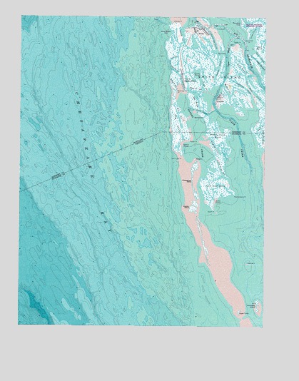
Ewell, MD USGS Topographic Map
Click on map above to begin viewing in our Map Viewer.

This topographic map contains these locations and features:
Feature Name Type Latitude Longitude GNIS ID View Map
Amen CornerBayN37.9243°W76.0235°1462442View Map
Bare MarshSwampN37.9882°W76.0002°583022View Map
Beaver HammockRidgeN37.9946°W76.0094°596771View Map
Big ThorofareChannelN37.9879°W76.0094°583238View Map
Calvary ChurchChurchN37.9754°W76.0410°583547View Map
Chaisey PointCapeN37.9976°W76.0460°583676View Map
Cheeseman IslandIslandN37.9357°W76.0380°1464766View Map
Easter PointCapeN37.9893°W76.0138°584229View Map
EwellPopulated PlaceN37.9957°W76.0333°590177View Map
Ewell Elementary SchoolSchoolN37.9941°W76.0341°596804View Map
Ewell Post OfficePost OfficeN37.9945°W76.0308°596805View Map
Ewell United Methodist ChurchChurchN37.9951°W76.0335°596806View Map
Ewell Volunteer Fire Department Station 1BuildingN37.9941°W76.0353°2131737View Map
Fishbone IslandIslandN37.8832°W76.0030°1466601View Map
Fishing CreekStreamN37.9426°W76.0185°1466611View Map
Fishing Creek MarshSwampN37.9521°W76.0230°1466613View Map
Frances GutGutN37.9926°W76.0410°584482View Map
Goose Harbor CoveBayN37.9932°W76.0502°584656View Map
Great PondLakeN37.9762°W76.0332°584733View Map
Herring IslandIslandN37.9004°W76.0080°1467959View Map
Hog NeckCapeN37.9573°W76.0441°585000View Map
Hunter GutGutN37.9601°W76.0297°585109View Map
Indian CreekGutN37.9798°W76.0227°585131View Map
Jeans GutGutN37.9723°W76.0313°585208View Map
Jones CreekBayN37.9846°W76.0022°585267View Map
Juggling CreekGutN37.9718°W76.0097°585277View Map
Levering CreekBayN37.9901°W76.0252°585407View Map
Long BranchBayN37.9790°W76.0113°585556View Map
Long CreekBayN37.9940°W76.0066°585569View Map
Long Creek PointCapeN37.9921°W76.0083°585572View Map
Merlin GutGutN37.9707°W76.0197°585796View Map
Mill GutGutN37.9612°W76.0433°585869View Map
Orchard RidgeRidgeN37.9946°W76.0447°596863View Map
Oyster PointCapeN37.9501°W76.0374°1472010View Map
Parks DitchCanalN37.9623°W76.0316°586417View Map
Peachorchard PointCapeN37.9279°W76.0147°1472148View Map
Point ComfortCapeN37.9951°W76.0247°586621View Map
Rhodes PointPopulated PlaceN37.9743°W76.0410°591121View Map
Rhodes Point GutGutN37.9701°W76.0349°586814View Map
Rock CreekStreamN37.9523°W76.0047°1473362View Map
Rock CreekGutN37.9696°W76.0044°586863View Map
Rocking PointCapeN37.9696°W76.0447°586897View Map
Rocking Point GutGutN37.9726°W76.0458°586898View Map
Sedge IslandIslandN37.9415°W76.0341°1474154View Map
Severn GutGutN37.9837°W76.0458°587284View Map
Shanks CreekStreamN37.9279°W76.0330°1474218View Map
Shanks CreekBayN37.9557°W76.0338°587300View Map
Shanks IslandIslandN37.9218°W76.0397°1474219View Map
Sheep Pen GutGutN37.9787°W76.0455°587315View Map
Smith Gut PointCapeN37.9432°W76.0416°1474752View Map
Smith IslandIslandN37.9748°W76.0224°587400View Map
Smith IslandPopulated PlaceN37.9812°W76.0299°1852600View Map
Smith Island Census Designated PlaceCensusN37.9743°W76.0266°2390308View Map
South PointCapeN37.9218°W76.0249°1474880View Map
South Point GutBayN37.9372°W76.0211°1474881View Map
South Point MarshSwampN37.9321°W76.0250°1474882View Map
Spain CoveBayN37.9471°W76.0394°1474927View Map
The CanalCanalN37.9862°W76.0222°587735View Map
The SloughChannelN37.9668°W76.0335°587755View Map
Thorofare CoveBayN37.9982°W76.0122°587780View Map
Tyler CreekStreamN37.9301°W76.0049°1476012View Map
Tyler DitchCanalN37.9851°W76.0188°587943View Map
TylertonPopulated PlaceN37.9679°W76.0230°591450View Map
Tylerton Elementary SchoolSchoolN37.9673°W76.0227°596917View Map
Tylerton Fire Department Station 7BuildingN37.9672°W76.0237°2131758View Map
Tylerton Post OfficePost OfficeN37.9686°W76.0232°596918View Map
Union United Methodist ChurchChurchN37.9676°W76.0233°596921View Map
Upper TumpIslandN37.8798°W76.0119°1476122View Map
Wading PlaceLocaleN37.9823°W76.0430°596927View Map

Note: Coordinates in the location and feature list above are referenced to NAD83 datum.


Copyright (C) 2008-2024 Ryan Niemi / Sunset Dynamics ... All Rights Reserved