TopoQuest Logo
Do you find TopoQuest useful?
Help keep TopoQuest running and adding new maps/features by donating!
Bitcoin:  19c7KJd3qBynnjoSw5npx9KScwjBe4ifkT
Litecoin:  LXs6TkuXGGXo1vDsWCkWVdjQX94eUKd6ui
Home View Maps Find Maps Find Places Resources & Links


Fairview, Oklahoma Topographic Map

USGS Map Title: Fairview, OK
USGS Map MRC: 36098C4
DRG (GeoTIFF) Download: o36098c4.tif


Neighboring USGS Topographic Map Quads:


  Glass Mountains NE, OK  
36098D5
 

  Cleo Springs, OK  
36098D4
 

  Fairview NE, OK  
36098D3
 

  Glass Mountains, OK  
36098C5
 

  Fairview, OK  
36098C4
 

  Fairview SE, OK  
36098C3
 

  Longdale, OK  
36098B5
 

  Homestead, OK  
36098B4
 

  Isabella, OK  
36098B3


Map MRC Location:

N37°
W99°
N37°
W98°
H8 H7 H6 H5 H4 H3 H2 H1
G8 G7 G6 G5 G4 G3 G2 G1
F8 F7 F6 F5 F4 F3 F2 F1
E8 E7 E6 E5 E4 E3 E2 E1
D8 D7 D6 D5 D4 D3 D2 D1
C8 C7 C6 C5 C4 C3 C2 C1
B8 B7 B6 B5 B4 B3 B2 B1
A8 A7 A6 A5 A4 A3 A2 A1
N36°
W99°
N36°
W98°

Fairview, OK USGS 1:24K Topographic Map Preview:
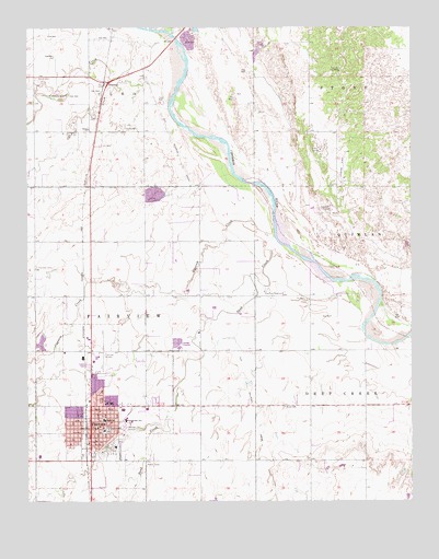
Fairview, OK USGS Topographic Map
Click on map above to begin viewing in our Map Viewer.

This topographic map contains these locations and features:
Feature Name Type Latitude Longitude GNIS ID View Map
Camp SalineLocaleN36.3417°W98.4065°1090875View Map
Central Christian ChurchChurchN36.2695°W98.4787°1798197View Map
Chamberlain Middle SchoolSchoolN36.2722°W98.4674°1091194View Map
Church of ChristChurchN36.2736°W98.4776°1798196View Map
Church of the NazareneChurchN36.2678°W98.4842°1798195View Map
City of FairviewCivilN36.2705°W98.4771°2410477View Map
Cornelsen Elementary SchoolSchoolN36.2733°W98.4663°1793670View Map
Cottonwood CreekStreamN36.3742°W98.4606°1091723View Map
Eagle Chief CreekStreamN36.3734°W98.4529°1092322View Map
Elm CreekStreamN36.3542°W98.4542°1092569View Map
FairviewPopulated PlaceN36.2689°W98.4798°1092705View Map
Fairview CemeteryCemeteryN36.3118°W98.4972°1092717View Map
Fairview City WellsWellN36.3267°W98.4040°1092735View Map
Fairview City WellsWellN36.3631°W98.3987°1092736View Map
Fairview Fire DepartmentBuildingN36.2683°W98.4780°2658341View Map
Fairview High SchoolSchoolN36.2716°W98.4756°1793669View Map
Fairview Municipal AirportAirportN36.2891°W98.4773°1102470View Map
Fairview Police DepartmentBuildingN36.2683°W98.4784°2757764View Map
Fairview Regional Medical CenterHospitalN36.2760°W98.4746°2695681View Map
Fairview ReservoirReservoirN36.3059°W98.4227°1092738View Map
First Baptist ChurchChurchN36.2695°W98.4762°1798194View Map
First United Methodist ChurchChurchN36.2695°W98.4776°1798193View Map
Gypsum CreekStreamN36.3192°W98.4204°1093460View Map
Major County Emergency Medical ServicesBuildingN36.2709°W98.4795°2695864View Map
Major County JailBuildingN36.2690°W98.4742°2757847View Map
Major County Sheriff's OfficeBuildingN36.2689°W98.4735°2757747View Map
Northwest Technology Center FairviewSchoolN36.2620°W98.4967°1793671View Map
OrientaPopulated PlaceN36.3600°W98.4740°1100704View Map
Rusk CemeteryCemeteryN36.2746°W98.4168°1097538View Map
Sand CreekStreamN36.3170°W98.4151°1097752View Map
Saron CemeteryCemeteryN36.3616°W98.4971°1097841View Map
Saron ChurchChurchN36.3481°W98.4804°1097842View Map

Note: Coordinates in the location and feature list above are referenced to NAD83 datum.


Copyright (C) 2008-2025 Ryan Niemi / Sunset Dynamics ... All Rights Reserved