TopoQuest Logo
Do you find TopoQuest useful?
Help keep TopoQuest running and adding new maps/features by donating!
Bitcoin:  19c7KJd3qBynnjoSw5npx9KScwjBe4ifkT
Litecoin:  LXs6TkuXGGXo1vDsWCkWVdjQX94eUKd6ui
Home View Maps Find Maps Find Places Resources & Links


Fall River, Kansas Topographic Map

USGS Map Title: Fall River, KS
USGS Map MRC: 37096E1
DRG (GeoTIFF) Download: o37096e1.tif


Neighboring USGS Topographic Map Quads:


  Severy North, KS  
37096F2
 

  Fall River Lake, KS  
37096F1
 

  Coyville, KS  
37095F8
 

  Severy South, KS  
37096E2
 

  Fall River, KS  
37096E1
 

  New Albany, KS  
37095E8
 

  Longton NW, KS  
37096D2
 

  Longton, KS  
37096D1
 

  Buxton, KS  
37095D8


Map MRC Location:

N38°
W97°
N38°
W96°
H8 H7 H6 H5 H4 H3 H2 H1
G8 G7 G6 G5 G4 G3 G2 G1
F8 F7 F6 F5 F4 F3 F2 F1
E8 E7 E6 E5 E4 E3 E2 E1
D8 D7 D6 D5 D4 D3 D2 D1
C8 C7 C6 C5 C4 C3 C2 C1
B8 B7 B6 B5 B4 B3 B2 B1
A8 A7 A6 A5 A4 A3 A2 A1
N37°
W97°
N37°
W96°

Fall River, KS USGS 1:24K Topographic Map Preview:
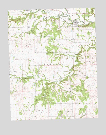
Fall River, KS USGS Topographic Map
Click on map above to begin viewing in our Map Viewer.

This topographic map contains these locations and features:
Feature Name Type Latitude Longitude GNIS ID View Map
Cave SpringsPopulated PlaceN37.5334°W96.1225°484956View Map
City of Fall RiverCivilN37.6078°W96.0285°2394739View Map
Clogston Ranch Landing Strip (historical)AirportN37.5581°W96.1189°475064View Map
Fall RiverPopulated PlaceN37.6078°W96.0280°475067View Map
Fall River Christian ChurchChurchN37.6051°W96.0292°2688655View Map
Fall River Fire DepartmentBuildingN37.6084°W96.0278°2111314View Map
Fall River Municipal Wastewater Treatment FacilityLocaleN37.6063°W96.0207°2692064View Map
Fall River Post OfficePost OfficeN37.6086°W96.0284°2693716View Map
Hideout School (historical)SchoolN37.5425°W96.0500°483600View Map
Little Indian CreekStreamN37.5420°W96.0717°475062View Map
Little Salt CreekStreamN37.6161°W96.0625°475066View Map
Mount Zion CemeteryCemeteryN37.5848°W96.0980°475065View Map
North Pole School (historical)SchoolN37.5906°W96.0972°483602View Map
Rule School (historical)SchoolN37.5467°W96.0789°483954View Map
Salt CreekStreamN37.6134°W96.0378°474864View Map
Township of LibertyCivilN37.5612°W96.0520°475068View Map
Union Valley School (historical)SchoolN37.5473°W96.1247°483605View Map
Victor School (historical)SchoolN37.5825°W96.0336°483606View Map
Wade CemeteryCemeteryN37.5435°W96.0883°475063View Map

Note: Coordinates in the location and feature list above are referenced to NAD83 datum.


Copyright (C) 2008-2024 Ryan Niemi / Sunset Dynamics ... All Rights Reserved