TopoQuest Logo
Do you find TopoQuest useful?
Help keep TopoQuest running and adding new maps/features by donating!
Bitcoin:  19c7KJd3qBynnjoSw5npx9KScwjBe4ifkT
Litecoin:  LXs6TkuXGGXo1vDsWCkWVdjQX94eUKd6ui
Home View Maps Find Maps Find Places Resources & Links


Fall River Mills, California Topographic Map

USGS Map Title: Fall River Mills, CA
USGS Map MRC: 41121A4
DRG (GeoTIFF) Download: o41121a4.tif


Neighboring USGS Topographic Map Quads:


  East of Pondosa, CA  
41121B5
 

  Timbered Crater, CA  
41121B4
 

  Day, CA  
41121B3
 

  Dana, CA  
41121A5
 

  Fall River Mills, CA  
41121A4
 

  Pittville, CA  
41121A3
 

  Cassel, CA  
40121H5
 

  Hogback Ridge, CA  
40121H4
 

  Coble Mountain, CA  
40121H3


Map MRC Location:

N42°
W122°
N42°
W121°
H8 H7 H6 H5 H4 H3 H2 H1
G8 G7 G6 G5 G4 G3 G2 G1
F8 F7 F6 F5 F4 F3 F2 F1
E8 E7 E6 E5 E4 E3 E2 E1
D8 D7 D6 D5 D4 D3 D2 D1
C8 C7 C6 C5 C4 C3 C2 C1
B8 B7 B6 B5 B4 B3 B2 B1
A8 A7 A6 A5 A4 A3 A2 A1
N41°
W122°
N41°
W121°

Fall River Mills, CA USGS 1:24K Topographic Map Preview:
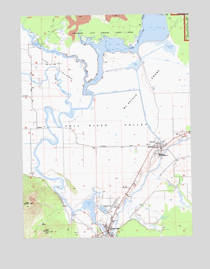
Fall River Mills, CA USGS Topographic Map
Click on map above to begin viewing in our Map Viewer.

This topographic map contains these locations and features:
Feature Name Type Latitude Longitude GNIS ID View Map
Big LakeLakeN41.1193°W121.4036°256954View Map
Crystal SpringsSpringN41.1118°W121.4494°258971View Map
Eastman LakeLakeN41.1092°W121.4902°259778View Map
Fall RiverStreamN41.0016°W121.4383°260032View Map
Fall River CemeteryCemeteryN41.0132°W121.4330°1682478View Map
Fall River Elementary SchoolSchoolN41.0064°W121.4404°1682479View Map
Fall River Junior - Senior High SchoolSchoolN41.0459°W121.3992°260034View Map
Fall River LakeLakeN41.0174°W121.4518°274916View Map
Fall River MillsPopulated PlaceN41.0046°W121.4383°260035View Map
Fall River Mills AirportAirportN41.0175°W121.4337°1653444View Map
Fall River Mills Census Designated PlaceCensusN41.0068°W121.4400°2408112View Map
Fall River Mills Fire Protection DistrictBuildingN41.0052°W121.4375°2622071View Map
Fall River Mills Post OfficePost OfficeN41.0121°W121.4348°1682480View Map
Fall River ValleyValleyN41.0082°W121.4472°260036View Map
Fort Crook MuseumBuildingN41.0027°W121.4469°1682484View Map
GlenburnPopulated PlaceN41.0613°W121.4903°260605View Map
Haney MountainSummitN41.0038°W121.4825°261062View Map
Hat Creek Ranger StationLocaleN41.0038°W121.4372°274915View Map
Hollenbeak SwampSwampN41.1067°W121.3973°261421View Map
Horr PondSwampN41.1095°W121.4269°261471View Map
Intermountain FairgroundsLocaleN41.0543°W121.4025°261795View Map
Island School (historical)SchoolN41.0974°W121.4930°253143View Map
Ja She CreekStreamN41.1060°W121.4455°1662316View Map
Knoch ReservoirReservoirN41.0108°W121.3987°1652847View Map
Lava CreekStreamN41.1093°W121.4922°262362View Map
Lee Drainage CanalCanalN41.0968°W121.3855°262396View Map
Little Tule RiverStreamN41.0863°W121.4522°262741View Map
Mayers Memorial HospitalHospitalN41.0236°W121.4240°1682501View Map
McArthurPopulated PlaceN41.0502°W121.3991°263294View Map
McArthur Census Designated PlaceCensusN41.0415°W121.4067°2408194View Map
McArthur Diversion CanalCanalN41.0804°W121.4133°263296View Map
McArthur Mobile Home ParkPopulated PlaceN41.0522°W121.3981°2508659View Map
McArthur Post OfficePost OfficeN41.0501°W121.4029°2760073View Map
McArthur SwampSwampN41.0832°W121.4178°263297View Map
McArthur Volunteer Fire Department Station 1BuildingN41.0500°W121.3967°2621806View Map
Peacock CreekStreamN41.0366°W121.4069°264588View Map
Pine Grove CemeteryCemeteryN41.0555°W121.3837°264759View Map
Pit Number 1 Diversion 97-099 DamDamN41.0135°W121.4644°1663654View Map
Pit Number 1 Forebay 97-110 DamDamN41.0082°W121.4477°1663667View Map
Rat Farm (not official)LocaleN41.0999°W121.4122°1667308View Map
Saddle MountainSummitN41.0196°W121.4958°267202View Map
Shelly CreekStreamN41.0196°W121.4216°266088View Map
The IslandIslandN41.0971°W121.4761°1652862View Map
The SaddleGapN41.0079°W121.4891°268211View Map
Tule RiverStreamN41.0721°W121.4639°268459View Map
Veterans Memorial HallBuildingN41.0029°W121.4428°1682529View Map

Note: Coordinates in the location and feature list above are referenced to NAD83 datum.


Copyright (C) 2008-2024 Ryan Niemi / Sunset Dynamics ... All Rights Reserved