TopoQuest Logo
Do you find TopoQuest useful?
Help keep TopoQuest running and adding new maps/features by donating!
Bitcoin:  19c7KJd3qBynnjoSw5npx9KScwjBe4ifkT
Litecoin:  LXs6TkuXGGXo1vDsWCkWVdjQX94eUKd6ui
Home View Maps Find Maps Find Places Resources & Links


Falls City, Texas Topographic Map

USGS Map Title: Falls City, TX
USGS Map MRC: 28098H1
DRG (GeoTIFF) Download: o28098h1.tif


Neighboring USGS Topographic Map Quads:


  Dewees, TX  
29098A2
 

  Poth, TX  
29098A1
 

  Kosciusko, TX  
29097A8
 

  Three Oaks, TX  
28098H2
 

  Falls City, TX  
28098H1
 

  Karnes City, TX  
28097H8
 

  Fashing, TX  
28098G2
 

  Coy City, TX  
28098G1
 

  Lenz, TX  
28097G8


Map MRC Location:

N29°
W99°
N29°
W98°
H8 H7 H6 H5 H4 H3 H2 H1
G8 G7 G6 G5 G4 G3 G2 G1
F8 F7 F6 F5 F4 F3 F2 F1
E8 E7 E6 E5 E4 E3 E2 E1
D8 D7 D6 D5 D4 D3 D2 D1
C8 C7 C6 C5 C4 C3 C2 C1
B8 B7 B6 B5 B4 B3 B2 B1
A8 A7 A6 A5 A4 A3 A2 A1
N28°
W99°
N28°
W98°

Falls City, TX USGS 1:24K Topographic Map Preview:
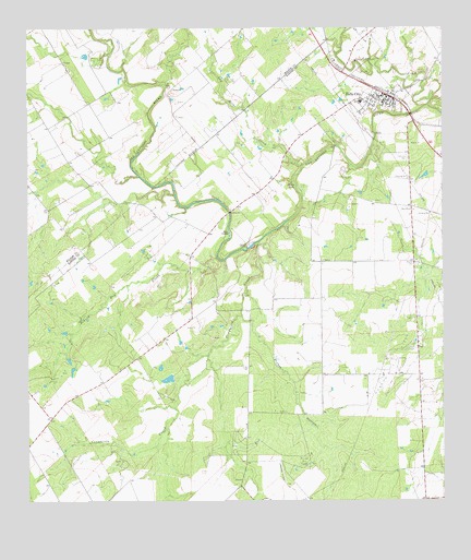
Falls City, TX USGS Topographic Map
Click on map above to begin viewing in our Map Viewer.

This topographic map contains these locations and features:
Feature Name Type Latitude Longitude GNIS ID View Map
Burris Ranch AirportAirportN28.8859°W98.0503°1386443View Map
City of Falls CityCivilN28.9822°W98.0217°2410483View Map
Conquista CreekStreamN28.9439°W98.0547°1354886View Map
Conquista CrossingPopulated PlaceN28.9428°W98.0572°1379588View Map
Conquista Project Tailings PondReservoirN28.8886°W98.1003°1865507View Map
Conquista Project Tailings Pond DamDamN28.8886°W98.1003°1865506View Map
DeweesvillePopulated PlaceN28.9025°W98.1236°2034705View Map
Falls CityPopulated PlaceN28.9828°W98.0175°1357209View Map
Falls City CemeteryCemeteryN28.9658°W98.0106°1357210View Map
Falls City City HallBuildingN28.9816°W98.0194°2753803View Map
Falls City DivisionCivilN28.9350°W98.0373°1938734View Map
Falls City Elementary SchoolSchoolN28.9808°W98.0236°2007073View Map
Falls City High SchoolSchoolN28.9808°W98.0236°2007074View Map
Falls City Post OfficePost OfficeN28.9813°W98.0190°2732219View Map
Falls City Volunteer Fire DepartmentBuildingN28.9820°W98.0180°2552244View Map
Hobson Oil FieldOilfieldN28.9128°W98.0158°1359327View Map
Hysaw Oil FieldOilfieldN28.8875°W98.0422°1359876View Map
Las Moras CreekStreamN28.9636°W98.0417°1360957View Map
Marcelinas CreekStreamN28.9800°W98.0042°1362165View Map
Mays CrossingPopulated PlaceN28.9464°W98.0639°1380161View Map
Mueller CemeteryCemeteryN28.9378°W98.0086°1363430View Map
Nieschwietz LakeReservoirN28.9077°W98.0826°1858284View Map
Nieschwietz Lake DamDamN28.9069°W98.0820°1858283View Map
Picket HollowValleyN28.9241°W98.0611°1375438View Map
Scared Dog CreekStreamN28.9397°W98.0678°1367820View Map
Skiles FallsFallsN28.9584°W98.0444°1368384View Map

Note: Coordinates in the location and feature list above are referenced to NAD83 datum.


Copyright (C) 2008-2025 Ryan Niemi / Sunset Dynamics ... All Rights Reserved