TopoQuest Logo
Do you find TopoQuest useful?
Help keep TopoQuest running and adding new maps/features by donating!
Bitcoin:  19c7KJd3qBynnjoSw5npx9KScwjBe4ifkT
Litecoin:  LXs6TkuXGGXo1vDsWCkWVdjQX94eUKd6ui
Home View Maps Find Maps Find Places Resources & Links


False Cape, Florida Topographic Map

USGS Map Title: False Cape, FL
USGS Map MRC: 28080E5
DRG (GeoTIFF) Download: o28080e5.tif


Neighboring USGS Topographic Map Quads:


  Wilson, FL  
28080F6


  Orsino, FL  
28080E6
 

  False Cape, FL  
28080E5


  Courtenay, FL  
28080D6
 

  Cape Canaveral, FL  
28080D5


Map MRC Location:

N29°
W81°
N29°
W80°
H8 H7 H6 H5 H4 H3 H2 H1
G8 G7 G6 G5 G4 G3 G2 G1
F8 F7 F6 F5 F4 F3 F2 F1
E8 E7 E6 E5 E4 E3 E2 E1
D8 D7 D6 D5 D4 D3 D2 D1
C8 C7 C6 C5 C4 C3 C2 C1
B8 B7 B6 B5 B4 B3 B2 B1
A8 A7 A6 A5 A4 A3 A2 A1
N28°
W81°
N28°
W80°

False Cape, FL USGS 1:24K Topographic Map Preview:
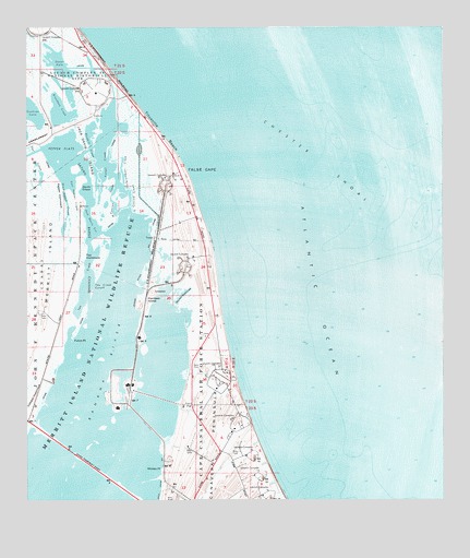
False Cape, FL USGS Topographic Map
Click on map above to begin viewing in our Map Viewer.

This topographic map contains these locations and features:
Feature Name Type Latitude Longitude GNIS ID View Map
Barge ChannelChannelN28.5678°W80.6062°278109View Map
Bluebill CreekBayN28.5966°W80.6055°279080View Map
Broadaxe CreekBayN28.6030°W80.6143°279421View Map
Chester ShoalBarN28.5894°W80.5350°280374View Map
Conrad CreekBayN28.5777°W80.5985°280720View Map
De Soto Beach (historical)BeachN28.5336°W80.5664°294374View Map
Devils ElbowBendN28.5831°W80.6081°281532View Map
East Conrad CreekBayN28.5802°W80.5937°281963View Map
East Pepper CreekStreamN28.5856°W80.6112°282014View Map
False CapeCapeN28.5875°W80.5762°282372View Map
Futch PointCapeN28.5433°W80.6103°282861View Map
Gator HoleBayN28.6157°W80.6152°282978View Map
Gulbrandson CreekBayN28.5881°W80.5963°283483View Map
Hamper HammockIslandN28.5278°W80.6226°283670View Map
Harrison IslandIslandN28.5525°W80.5887°283771View Map
Harrison Road CreekStreamN28.5519°W80.5798°283774View Map
Jack Davis CutChannelN28.5753°W80.6053°284656View Map
Jack Davis IslandIslandN28.5914°W80.6062°284657View Map
Launch Complex 16LocaleN28.5033°W80.5517°285375View Map
Launch Complex 19LocaleN28.5086°W80.5542°285378View Map
Launch Complex 20LocaleN28.5142°W80.5564°285379View Map
Launch Complex 34LocaleN28.5217°W80.5612°285386View Map
Launch Complex 37LocaleN28.5350°W80.5656°285389View Map
Launch Complex 39BLocaleN28.6242°W80.6203°307746View Map
Launch Complex 40LocaleN28.5647°W80.5748°285390View Map
Launch Complex 41LocaleN28.5858°W80.5814°285391View Map
Pepper FlatsFlatN28.5925°W80.6145°288709View Map
Pepper HammockIslandN28.5814°W80.6150°288711View Map
Pintail CreekBayN28.5889°W80.6020°288979View Map
Tea CreekBayN28.5585°W80.6068°292080View Map
Tea Creek CutoffChannelN28.5569°W80.6045°292081View Map
Tea HammockIslandN28.5650°W80.6070°292082View Map
Titusville BeachBeachN28.5978°W80.5834°292320View Map
West Pepper CreekStreamN28.5850°W80.6137°293109View Map
Whites PointCapeN28.5086°W80.5845°295022View Map

Note: Coordinates in the location and feature list above are referenced to NAD83 datum.


Copyright (C) 2008-2024 Ryan Niemi / Sunset Dynamics ... All Rights Reserved