TopoQuest Logo
Do you find TopoQuest useful?
Help keep TopoQuest running and adding new maps/features by donating!
Bitcoin:  19c7KJd3qBynnjoSw5npx9KScwjBe4ifkT
Litecoin:  LXs6TkuXGGXo1vDsWCkWVdjQX94eUKd6ui
Home View Maps Find Maps Find Places Resources & Links


Fellsmere NW, Florida Topographic Map

USGS Map Title: Fellsmere NW, FL
USGS Map MRC: 27080H6
DRG (GeoTIFF) Download: o27080h6.tif


Neighboring USGS Topographic Map Quads:


  Deer Park SE, FL  
28080A7
 

  Melbourne West, FL  
28080A6
 

  Melbourne East, FL  
28080A5
 

  Kenansville NE, FL  
27080H7
 

  Fellsmere NW, FL  
27080H6
 

  Grant, FL  
27080H5
 

  Kenansville SE, FL  
27080G7
 

  Fellsmere SW, FL  
27080G6
 

  Fellsmere, FL  
27080G5


Map MRC Location:

N28°
W81°
N28°
W80°
H8 H7 H6 H5 H4 H3 H2 H1
G8 G7 G6 G5 G4 G3 G2 G1
F8 F7 F6 F5 F4 F3 F2 F1
E8 E7 E6 E5 E4 E3 E2 E1
D8 D7 D6 D5 D4 D3 D2 D1
C8 C7 C6 C5 C4 C3 C2 C1
B8 B7 B6 B5 B4 B3 B2 B1
A8 A7 A6 A5 A4 A3 A2 A1
N27°
W81°
N27°
W80°

Fellsmere NW, FL USGS 1:24K Topographic Map Preview:
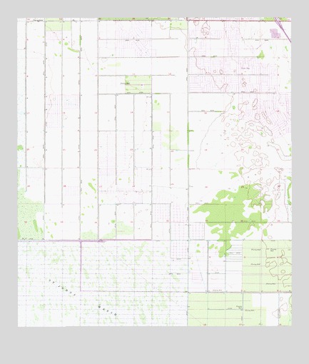
Fellsmere NW, FL USGS Topographic Map
Click on map above to begin viewing in our Map Viewer.

This topographic map contains these locations and features:
Feature Name Type Latitude Longitude GNIS ID View Map
Brevard Community College Palm Bay Campus Administration and General Instruction BuildingSchoolN27.9933°W80.6303°2451727View Map
Brevard Community College Palm Bay Campus Brevard Community College and University of Central FloridSchoolN27.9931°W80.6310°2451728View Map
Brevard Community College Palm Bay Campus Child Development Center and University of Florida AgriculSchoolN27.9843°W80.6307°2451729View Map
Brevard Community College Palm Bay Campus Criminal Justice Driving PadSchoolN27.9878°W80.6300°2451730View Map
Brevard Community College Palm Bay Campus Library and Science BuildingSchoolN27.9944°W80.6305°2451731View Map
Brevard Community College Palm Bay Campus Multiuse Classroom BuildingSchoolN27.9871°W80.6292°2451732View Map
Brevard Community College Palm Bay Campus Palm Bay Aquatic CenterSchoolN27.9905°W80.6297°2451733View Map
Brevard Community College Palm Bay Campus Ropes CourseSchoolN27.9868°W80.6289°2451734View Map
Brevard Community College Palm Bay Campus Softball FieldSchoolN27.9891°W80.6312°2451735View Map
Brevard County Fire Rescue Station 89BuildingN27.9479°W80.6762°2644479View Map
Brevard County Public Library System Franklin T Degroodt Memorial LibraryBuildingN27.9963°W80.6704°2451736View Map
City of Palm BayCivilN27.9861°W80.6628°2404463View Map
John F Turner Senior Elementary SchoolSchoolN27.9885°W80.6606°297068View Map
Joy Lutheran ChurchChurchN27.9868°W80.6603°2451764View Map
Palm Bay DivisionCivilN27.9859°W80.6610°1935886View Map
Palm Bay Fire Department Station 2BuildingN27.9987°W80.6692°2331315View Map
Palm Bay Fire Department Station 4BuildingN27.9520°W80.6285°2331316View Map
Palm Bay Fire Department Station 5BuildingN27.9934°W80.6342°2331317View Map
Palm Bay Police DepartmentBuildingN27.9977°W80.6695°2331439View Map
Palm Bay West Post OfficePost OfficeN27.9981°W80.6980°2451742View Map
Pentecostal Apostolic ChurchChurchN27.9879°W80.6694°2451769View Map
Ringhaver HeliportAirportN27.9892°W80.6267°309797View Map
Riverwood Golf ClubLocaleN27.9497°W80.6530°2451738View Map
The Church of the Holy Bible ApostolicChurchN27.9329°W80.6353°2451777View Map
Willowbrook Farms Mobile Home ParkPopulated PlaceN27.8877°W80.6662°2451749View Map
Zion Christian ChurchChurchN27.9943°W80.6470°2451779View Map

Note: Coordinates in the location and feature list above are referenced to NAD83 datum.


Copyright (C) 2008-2024 Ryan Niemi / Sunset Dynamics ... All Rights Reserved