TopoQuest Logo
Do you find TopoQuest useful?
Help keep TopoQuest running and adding new maps/features by donating!
Bitcoin:  19c7KJd3qBynnjoSw5npx9KScwjBe4ifkT
Litecoin:  LXs6TkuXGGXo1vDsWCkWVdjQX94eUKd6ui
Home View Maps Find Maps Find Places Resources & Links


Flag Island, Minnesota Topographic Map

USGS Map Title: Flag Island, MN
USGS Map MRC: 49094C8
DRG (GeoTIFF) Download: o49094c8.tif


Neighboring USGS Topographic Map Quads:


  Angle Inlet, MN  
49095C1
 

  Flag Island, MN  
49094C8
 

  Oak Island, MN  
49094C7
 

  Buffalo Bay NE, MN  
49095B1
 

  Garden Island West, MN  
49094B8
 

  Garden Island East, MN  
49094B7


Map MRC Location:

N50°
W95°
N50°
W94°
H8 H7 H6 H5 H4 H3 H2 H1
G8 G7 G6 G5 G4 G3 G2 G1
F8 F7 F6 F5 F4 F3 F2 F1
E8 E7 E6 E5 E4 E3 E2 E1
D8 D7 D6 D5 D4 D3 D2 D1
C8 C7 C6 C5 C4 C3 C2 C1
B8 B7 B6 B5 B4 B3 B2 B1
A8 A7 A6 A5 A4 A3 A2 A1
N49°
W95°
N49°
W94°

Flag Island, MN USGS 1:24K Topographic Map Preview:
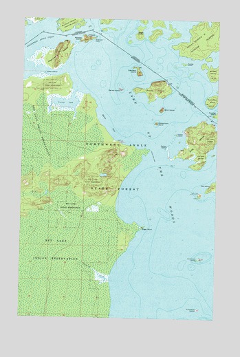
Flag Island, MN USGS Topographic Map
Click on map above to begin viewing in our Map Viewer.

This topographic map contains these locations and features:
Feature Name Type Latitude Longitude GNIS ID View Map
American PointCapeN49.3669°W94.9544°639326View Map
Birch IslandIslandN49.3372°W94.9108°640163View Map
Brush IslandIslandN49.3458°W94.9141°640562View Map
Collins IslandIslandN49.3269°W94.9011°641401View Map
Crowduck IslandIslandN49.2539°W94.8855°642512View Map
Dahler IslandIslandN49.3208°W94.9069°642591View Map
Ester IslandIslandN49.3519°W94.9858°643417View Map
Flag IslandIslandN49.3247°W94.8852°643723View Map
Flag Island ReefBarN49.3353°W94.8813°663191View Map
Fort Saint CharlesPopulated PlaceN49.3619°W94.9808°654709View Map
Fourblock IslandIslandN49.2750°W94.8855°643848View Map
Honeymoon IslandIslandN49.3317°W94.9141°645154View Map
Lake Trails Church CampLocaleN49.3022°W94.8858°646396View Map
Lambert IslandIslandN49.3528°W94.9252°643145View Map
Magnusons IslandIslandN49.3597°W94.9783°647378View Map
Maries IslandIslandN49.3456°W94.9369°647533View Map
Moose BayBayN49.3300°W94.9433°648072View Map
Northwest Angle State ForestForestN49.3111°W94.9413°648739View Map
PenassePopulated PlaceN49.3678°W94.9588°649255View Map
Penasse IslandIslandN49.3667°W94.9600°649256View Map
Penasse Post Office (historical)Post OfficeN49.3678°W94.9586°2100825View Map
Pickeral CreekStreamN49.2656°W94.9425°649359View Map
Pierre Gaultier De Varennes-Sieur De La Verendrye Historical MarkerParkN49.3619°W94.9806°2103974View Map
Sugar PointCapeN49.2881°W94.9216°652775View Map
Sugar Point Post Office (historical)Post OfficeN49.2878°W94.9236°2100773View Map
Sugar Point Post Office (historical)Post OfficeN49.2878°W94.9236°2100774View Map
Unorganized Territory of District 5 (historical)CensusN49.2544°W94.9377°663985View Map
Youngs BayBayN49.3397°W94.9727°654427View Map

Note: Coordinates in the location and feature list above are referenced to NAD83 datum.


Copyright (C) 2008-2024 Ryan Niemi / Sunset Dynamics ... All Rights Reserved