TopoQuest Logo
Do you find TopoQuest useful?
Help keep TopoQuest running and adding new maps/features by donating!
Bitcoin:  19c7KJd3qBynnjoSw5npx9KScwjBe4ifkT
Litecoin:  LXs6TkuXGGXo1vDsWCkWVdjQX94eUKd6ui
Home View Maps Find Maps Find Places Resources & Links


Flat Rock, Ohio Topographic Map

USGS Map Title: Flat Rock, OH
USGS Map MRC: 41082B7
DRG (GeoTIFF) Download: o41082b7.tif


Neighboring USGS Topographic Map Quads:


  Clyde, OH  
41082C8
 

  Bellevue, OH  
41082C7
 

  Kimball, OH  
41082C6
 

  Fireside, OH  
41082B8
 

  Flat Rock, OH  
41082B7
 

  Monroeville, OH  
41082B6
 

  Attica, OH  
41082A8
 

  Centerton, OH  
41082A7
 

  Willard, OH  
41082A6


Map MRC Location:

N42°
W83°
N42°
W82°
H8 H7 H6 H5 H4 H3 H2 H1
G8 G7 G6 G5 G4 G3 G2 G1
F8 F7 F6 F5 F4 F3 F2 F1
E8 E7 E6 E5 E4 E3 E2 E1
D8 D7 D6 D5 D4 D3 D2 D1
C8 C7 C6 C5 C4 C3 C2 C1
B8 B7 B6 B5 B4 B3 B2 B1
A8 A7 A6 A5 A4 A3 A2 A1
N41°
W83°
N41°
W82°

Flat Rock, OH USGS 1:24K Topographic Map Preview:
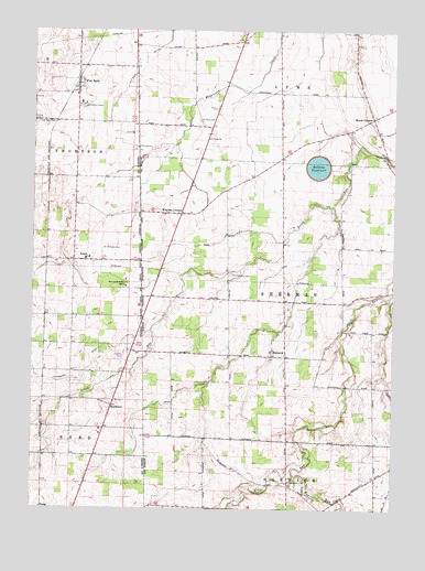
Flat Rock, OH USGS Topographic Map
Click on map above to begin viewing in our Map Viewer.

This topographic map contains these locations and features:
Feature Name Type Latitude Longitude GNIS ID View Map
Bellevue ReservoirReservoirN41.2146°W82.7765°1078938View Map
Bellevue Reservoir Number Five DamDamN41.2151°W82.7749°1078937View Map
BismarckPopulated PlaceN41.1651°W82.7871°1064440View Map
Bismark Post Office (historical)Post OfficeN41.1653°W82.7874°2010356View Map
Bollenbacher School (historical)SchoolN41.2453°W82.8191°1053244View Map
Bores FarmLocaleN41.2092°W82.7875°2740796View Map
Boughton CemeteryCemeteryN41.1323°W82.7849°1038210View Map
Central School (historical)SchoolN41.1792°W82.7880°1053245View Map
Dougherty AirportAirportN41.2442°W82.8671°2442497View Map
Ebenezer United Methodist ChurchChurchN41.2331°W82.8602°1055684View Map
English School (historical)SchoolN41.1728°W82.8071°1069572View Map
Flat RockPopulated PlaceN41.2359°W82.8602°1064655View Map
Flat Rock CemeteryCemeteryN41.2259°W82.8738°1040505View Map
Flat Rock Census Designated PlaceCensusN41.2355°W82.8592°2628891View Map
Flat Rock Childrens CenterSchoolN41.2298°W82.8574°1055688View Map
Flat Rock Post OfficePost OfficeN41.2362°W82.8596°2045553View Map
Flat Rock QuarryMineN41.2331°W82.8739°2567533View Map
Fouthon School (historical)SchoolN41.1309°W82.7841°1053249View Map
FrankPopulated PlaceN41.1898°W82.8580°1064672View Map
Frank Post Office (historical)Post OfficeN41.1903°W82.8582°2045533View Map
H B FarmsLocaleN41.1947°W82.7672°2740922View Map
Haas DitchCanalN41.1967°W82.8069°1041226View Map
Havana Post Office (historical)Post OfficeN41.1376°W82.7568°2010371View Map
Hayward DitchCanalN41.2417°W82.8391°1041427View Map
Heyman CemeteryCemeteryN41.2203°W82.7544°1806300View Map
Hickory Grove FarmsLocaleN41.2331°W82.8067°2740906View Map
Hunts CornersPopulated PlaceN41.2276°W82.7574°1064881View Map
Jones CemeteryCemeteryN41.1864°W82.8055°1806303View Map
Magers FarmsLocaleN41.2306°W82.7833°2740795View Map
Mud RunStreamN41.1331°W82.7846°1043688View Map
ReedtownPopulated PlaceN41.1520°W82.8471°1061591View Map
Reedtown Post Office (historical)Post OfficeN41.1514°W82.8477°2045542View Map
Saint Michaels CemeteryCemeteryN41.1928°W82.8513°1045713View Map
Saint Pauls CemeteryCemeteryN41.2270°W82.8176°1045753View Map
Saint Sebastian Catholic CemeteryCemeteryN41.1642°W82.7916°1806323View Map
Saint Sebastian Catholic ChurchChurchN41.1645°W82.7919°1806324View Map
Schoeffel DitchCanalN41.1617°W82.8552°1046009View Map
School Number 1 (historical)SchoolN41.2409°W82.8602°1053679View Map
School Number 1 (historical)SchoolN41.1614°W82.7574°1053260View Map
School Number 2 (historical)SchoolN41.1256°W82.8149°1053264View Map
School Number 6 (historical)SchoolN41.2112°W82.8605°1053690View Map
Siesel FarmsLocaleN41.1644°W82.8258°2740797View Map
Sorrowfull Mother ShrineLocaleN41.1831°W82.8430°1046434View Map
Stockmaster FarmsLocaleN41.1903°W82.8717°2740793View Map
Township of LymeCivilN41.2498°W82.7855°1086349View Map
Township of ShermanCivilN41.1794°W82.7874°1086359View Map
Tri View FarmsLocaleN41.1642°W82.8083°2740907View Map
Weavers CornersPopulated PlaceN41.2017°W82.8246°1061725View Map
Weavers Corners Post Office (historical)Post OfficeN41.2014°W82.8249°2011578View Map
Weymouth Post Office (historical)Post OfficeN41.1862°W82.7944°2036147View Map
Windfall Post Office (historical)Post OfficeN41.1362°W82.8194°2036149View Map
Woodside FarmsLocaleN41.2483°W82.8047°2740802View Map
Zieber Egg FarmLocaleN41.2422°W82.8722°2725571View Map

Note: Coordinates in the location and feature list above are referenced to NAD83 datum.


Copyright (C) 2008-2025 Ryan Niemi / Sunset Dynamics ... All Rights Reserved