TopoQuest Logo
Do you find TopoQuest useful?
Help keep TopoQuest running and adding new maps/features by donating!
Bitcoin:  19c7KJd3qBynnjoSw5npx9KScwjBe4ifkT
Litecoin:  LXs6TkuXGGXo1vDsWCkWVdjQX94eUKd6ui
Home View Maps Find Maps Find Places Resources & Links


Floate Draw, Wyoming Topographic Map

USGS Map Title: Floate Draw, WY
USGS Map MRC: 44106D3
DRG (GeoTIFF) Download: o44106d3.tif


Neighboring USGS Topographic Map Quads:


  Julio Draw, WY  
44106E4
 

  Arpan Butte, WY  
44106E3
 

  Jewell Draw, WY  
44106E2
 

  Fredrick Draw, WY  
44106D4
 

  Floate Draw, WY  
44106D3
 

  Mitchell Draw, WY  
44106D2
 

  Pine Gulch, WY  
44106C4
 

  Bear Draw, WY  
44106C3
 

  Somerville Flats West, WY  
44106C2


Map MRC Location:

N45°
W107°
N45°
W106°
H8 H7 H6 H5 H4 H3 H2 H1
G8 G7 G6 G5 G4 G3 G2 G1
F8 F7 F6 F5 F4 F3 F2 F1
E8 E7 E6 E5 E4 E3 E2 E1
D8 D7 D6 D5 D4 D3 D2 D1
C8 C7 C6 C5 C4 C3 C2 C1
B8 B7 B6 B5 B4 B3 B2 B1
A8 A7 A6 A5 A4 A3 A2 A1
N44°
W107°
N44°
W106°

Floate Draw, WY USGS 1:24K Topographic Map Preview:
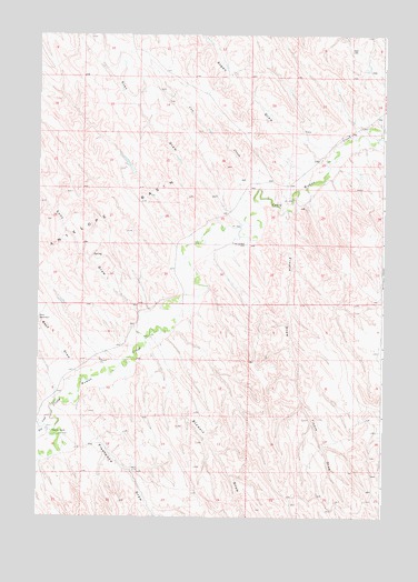
Floate Draw, WY USGS Topographic Map
Click on map above to begin viewing in our Map Viewer.

This topographic map contains these locations and features:
Feature Name Type Latitude Longitude GNIS ID View Map
Antelope BasinBasinN44.4447°W106.3720°1584846View Map
Arpan DrawValleyN44.4714°W106.2781°1584946View Map
Bass DrawValleyN44.4125°W106.3609°1585186View Map
Cheri L DamDamN44.4833°W106.2723°1606350View Map
Cheri L ReservoirReservoirN44.4833°W106.2723°1606351View Map
Clay DrawValleyN44.4530°W106.3048°1586753View Map
Cow CreekStreamN44.4603°W106.2959°1587106View Map
Dry CreekStreamN44.4022°W106.3698°1587810View Map
Fish Stockwater DamDamN44.3900°W106.2706°1606408View Map
Fish Stockwater ReservoirReservoirN44.3900°W106.2706°1606409View Map
Fleetwood DrawValleyN44.4036°W106.3606°1588581View Map
Floate DrawValleyN44.4525°W106.2867°1588589View Map
Hepp DamDamN44.4783°W106.2539°1607030View Map
Hepp Number 2 DamDamN44.4600°W106.3173°1606640View Map
Hepp Number 2 ReservoirReservoirN44.4600°W106.3173°1606641View Map
Hepp ReservoirReservoirN44.4783°W106.2539°1607031View Map
Hoffman DamDamN44.4350°W106.3106°1606884View Map
Hoffman ReservoirReservoirN44.4350°W106.3106°1606885View Map
Kimberly DamDamN44.4750°W106.3123°1606818View Map
Kimberly ReservoirReservoirN44.4751°W106.3134°1606819View Map
Mary Number 2 DamDamN44.4766°W106.2823°1606672View Map
Mary Number 2 ReservoirReservoirN44.4766°W106.2823°1606673View Map
Mary ReservoirReservoirN44.4833°W106.3289°1606359View Map
Mary Stock DamDamN44.4833°W106.3289°1606358View Map
Sony DrawValleyN44.4280°W106.3389°1594570View Map
Stewart DrawValleyN44.4175°W106.3339°1595050View Map
Tipperary RanchLocaleN44.3972°W106.3700°1595597View Map

Note: Coordinates in the location and feature list above are referenced to NAD83 datum.


Copyright (C) 2008-2024 Ryan Niemi / Sunset Dynamics ... All Rights Reserved