TopoQuest Logo
Do you find TopoQuest useful?
Help keep TopoQuest running and adding new maps/features by donating!
Bitcoin:  19c7KJd3qBynnjoSw5npx9KScwjBe4ifkT
Litecoin:  LXs6TkuXGGXo1vDsWCkWVdjQX94eUKd6ui
Home View Maps Find Maps Find Places Resources & Links


Fog Mountain, Idaho Topographic Map

USGS Map Title: Fog Mountain, ID
USGS Map MRC: 46115A2
DRG (GeoTIFF) Download: o46115a2.tif


Neighboring USGS Topographic Map Quads:


  Chimney Peak, ID  
46115B3
 

  Fenn Mountain, ID  
46115B2
 

  Big Rock Mountain, ID  
46115B1
 

  Selway Falls, ID  
46115A3
 

  Fog Mountain, ID  
46115A2
 

  Mink Peak, ID  
46115A1
 

  Anderson Butte, ID  
45115H3
 

  Vermilion Peak, ID  
45115H2
 

  Running Lake, ID  
45115H1


Map MRC Location:

N47°
W116°
N47°
W115°
H8 H7 H6 H5 H4 H3 H2 H1
G8 G7 G6 G5 G4 G3 G2 G1
F8 F7 F6 F5 F4 F3 F2 F1
E8 E7 E6 E5 E4 E3 E2 E1
D8 D7 D6 D5 D4 D3 D2 D1
C8 C7 C6 C5 C4 C3 C2 C1
B8 B7 B6 B5 B4 B3 B2 B1
A8 A7 A6 A5 A4 A3 A2 A1
N46°
W116°
N46°
W115°

Fog Mountain, ID USGS 1:24K Topographic Map Preview:
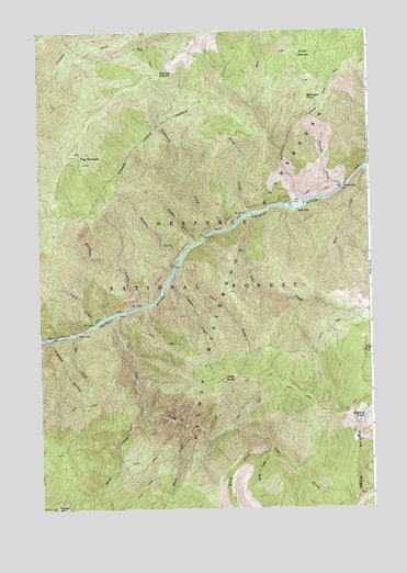
Fog Mountain, ID USGS Topographic Map
Click on map above to begin viewing in our Map Viewer.

This topographic map contains these locations and features:
Feature Name Type Latitude Longitude GNIS ID View Map
Bait CreekStreamN46.0585°W115.2029°376857View Map
Ballinger CreekStreamN46.0788°W115.1521°399768View Map
Ballinger PointCliffN46.1077°W115.1482°376918View Map
Bat CreekStreamN46.0455°W115.2385°377026View Map
Berry CreekStreamN46.0155°W115.1640°377408View Map
Big Fog SaddleGapN46.1138°W115.2040°377532View Map
Birch CreekStreamN46.0146°W115.1651°377654View Map
Bluff CreekStreamN46.0257°W115.2118°377966View Map
Cascade CreekStreamN46.0835°W115.1357°378967View Map
Coon CreekStreamN46.0646°W115.1973°379663View Map
Cupboard CreekStreamN46.0730°W115.1798°399843View Map
Fog MountainSummitN46.0932°W115.2365°381897View Map
Hidden CreekStreamN46.0699°W115.1910°383138View Map
Highline LakesLakeN46.0247°W115.1281°383188View Map
Highline RidgeRidgeN46.0035°W115.1304°382501View Map
Jims CreekStreamN46.0769°W115.1718°383922View Map
Maiden CreekStreamN46.0671°W115.1954°399979View Map
Mica CreekStreamN46.0216°W115.1962°386767View Map
Moose MeadowsFlatN46.1188°W115.1487°387195View Map
Otter ButteSummitN46.0330°W115.1818°388013View Map
Otter CreekStreamN46.0510°W115.2207°388018View Map
Power CreekStreamN46.0777°W115.1707°388843View Map
Renshaw CreekStreamN46.0535°W115.2093°400059View Map
Tepee CreekStreamN46.0488°W115.2296°391932View Map
Wolf CreekStreamN46.0885°W115.1268°393621View Map

Note: Coordinates in the location and feature list above are referenced to NAD83 datum.


Copyright (C) 2008-2025 Ryan Niemi / Sunset Dynamics ... All Rights Reserved