TopoQuest Logo
Do you find TopoQuest useful?
Help keep TopoQuest running and adding new maps/features by donating!
Bitcoin:  19c7KJd3qBynnjoSw5npx9KScwjBe4ifkT
Litecoin:  LXs6TkuXGGXo1vDsWCkWVdjQX94eUKd6ui
Home View Maps Find Maps Find Places Resources & Links


Fordoche, Louisiana Topographic Map

USGS Map Title: Fordoche, LA
USGS Map MRC: 30091E5
DRG (GeoTIFF) Download: o30091e5.tif


Neighboring USGS Topographic Map Quads:


  Melville, LA  
30091F6
 

  Morganza, LA  
30091F5
 

  New Roads, LA  
30091F4
 

  Lottie, LA  
30091E6
 

  Fordoche, LA  
30091E5
 

  Erwinville, LA  
30091E4
 

  Maringouin NW, LA  
30091D6
 

  Maringouin, LA  
30091D5
 

  Grosse Tete, LA  
30091D4


Map MRC Location:

N31°
W92°
N31°
W91°
H8 H7 H6 H5 H4 H3 H2 H1
G8 G7 G6 G5 G4 G3 G2 G1
F8 F7 F6 F5 F4 F3 F2 F1
E8 E7 E6 E5 E4 E3 E2 E1
D8 D7 D6 D5 D4 D3 D2 D1
C8 C7 C6 C5 C4 C3 C2 C1
B8 B7 B6 B5 B4 B3 B2 B1
A8 A7 A6 A5 A4 A3 A2 A1
N30°
W92°
N30°
W91°

Fordoche, LA USGS 1:24K Topographic Map Preview:
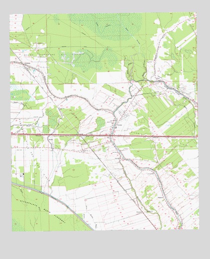
Fordoche, LA USGS Topographic Map
Click on map above to begin viewing in our Map Viewer.

This topographic map contains these locations and features:
Feature Name Type Latitude Longitude GNIS ID View Map
Bailey CemeteryCemeteryN30.5624°W91.5573°532279View Map
Bayou BlackStreamN30.5857°W91.5448°532446View Map
Bayou BlueStreamN30.5852°W91.5298°532455View Map
Bayou BlueStreamN30.6221°W91.5001°532457View Map
Bayou CascareStreamN30.6188°W91.5501°553427View Map
Bayou FordocheStreamN30.5680°W91.5559°553454View Map
Bayou Fordoche Oil FieldOilfieldN30.6016°W91.5934°553455View Map
Bayou GeorgeStreamN30.5860°W91.5321°532607View Map
Bayou PortageStreamN30.5863°W91.5440°532739View Map
BlanksPopulated PlaceN30.5532°W91.6004°542998View Map
Blanks Post OfficePost OfficeN30.5471°W91.5940°1630506View Map
Faith Baptist Church of LivoniaChurchN30.5555°W91.5485°2601616View Map
False RiverPopulated PlaceN30.5705°W91.5929°542153View Map
False River CemeteryCemeteryN30.5710°W91.5923°534900View Map
FordochePopulated PlaceN30.5960°W91.6165°543211View Map
Fordoche Baptist ChurchChurchN30.5940°W91.6103°2602005View Map
Fordoche Oil and Gas FieldOilfieldN30.5505°W91.6212°535032View Map
Fordoche Police DepartmentBuildingN30.5923°W91.6054°2334030View Map
Fordoche Post OfficePost OfficeN30.5891°W91.6028°1630515View Map
Fordoche Volunteer Fire DepartmentBuildingN30.5931°W91.6050°2691747View Map
FriscoPopulated PlaceN30.5857°W91.5257°554491View Map
Frisco Oil FieldOilfieldN30.5794°W91.5190°535128View Map
FrogmorePopulated PlaceN30.5194°W91.5243°543222View Map
Iris SpurLocaleN30.5305°W91.5562°542156View Map
KenmorePopulated PlaceN30.5096°W91.5404°543351View Map
Kingdom Hall of Jehovahs WitnessesChurchN30.5287°W91.5252°2602131View Map
Little Zion ChurchChurchN30.5449°W91.5529°536628View Map
LivoniaPopulated PlaceN30.5591°W91.5559°543403View Map
Livonia High SchoolSchoolN30.5592°W91.5552°546237View Map
Livonia Oil FieldOilfieldN30.5521°W91.5279°536640View Map
Livonia Police DepartmentBuildingN30.5590°W91.5561°2334098View Map
Livonia Post OfficePost OfficeN30.5573°W91.5560°1630527View Map
Livonia Volunteer Fire DepartmentBuildingN30.5677°W91.5488°2332427View Map
Mount Pilgrim ChurchChurchN30.5107°W91.5354°537377View Map
Pointe Coupee Parish Library Livonia BranchBuildingN30.5586°W91.5558°2603116View Map
Pointe Coupee Parish Sheriff's OfficeBuildingN30.5596°W91.5548°2334018View Map
QuickPopulated PlaceN30.5555°W91.5790°543606View Map
Rainbow Head Start Center SchoolSchoolN30.5321°W91.5302°2600253View Map
Saint Caprina ChurchChurchN30.5682°W91.5493°542162View Map
Saint Francis of Cabrini Catholic ChurchChurchN30.5682°W91.5496°546267View Map
Saint Matthews ChurchChurchN30.5416°W91.5507°542163View Map
Sunlight ChurchChurchN30.5460°W91.5779°539729View Map
Town of FordocheCivilN30.5940°W91.6179°2406504View Map
Town of LivoniaCivilN30.5622°W91.5501°2406031View Map
ValverdaPopulated PlaceN30.5416°W91.5521°556322View Map
Valverda Elementary SchoolSchoolN30.5324°W91.5302°1629798View Map
Valverda StripAirportN30.5248°W91.5271°2676775View Map
Ward TenCivilN30.6024°W91.5723°545167View Map

Note: Coordinates in the location and feature list above are referenced to NAD83 datum.


Copyright (C) 2008-2025 Ryan Niemi / Sunset Dynamics ... All Rights Reserved