TopoQuest Logo
Do you find TopoQuest useful?
Help keep TopoQuest running and adding new maps/features by donating!
Bitcoin:  19c7KJd3qBynnjoSw5npx9KScwjBe4ifkT
Litecoin:  LXs6TkuXGGXo1vDsWCkWVdjQX94eUKd6ui
Home View Maps Find Maps Find Places Resources & Links


Forsyth, Montana Topographic Map

USGS Map Title: Forsyth, MT
USGS Map MRC: 46106C6
DRG (GeoTIFF) Download: o46106c6.tif


Neighboring USGS Topographic Map Quads:


  Finch NE, MT  
46106D7
 

  Black Coulee, MT  
46106D6
 

  Schultz Coulee, MT  
46106D5
 

  Nichols, MT  
46106C7
 

  Forsyth, MT  
46106C6
 

  Orinoco, MT  
46106C5
 

  Griffin Coulee NE, MT  
46106B7
 

  Smith Creek, MT  
46106B6
 

  Smith Creek NE, MT  
46106B5


Map MRC Location:

N47°
W107°
N47°
W106°
H8 H7 H6 H5 H4 H3 H2 H1
G8 G7 G6 G5 G4 G3 G2 G1
F8 F7 F6 F5 F4 F3 F2 F1
E8 E7 E6 E5 E4 E3 E2 E1
D8 D7 D6 D5 D4 D3 D2 D1
C8 C7 C6 C5 C4 C3 C2 C1
B8 B7 B6 B5 B4 B3 B2 B1
A8 A7 A6 A5 A4 A3 A2 A1
N46°
W107°
N46°
W106°

Forsyth, MT USGS 1:24K Topographic Map Preview:
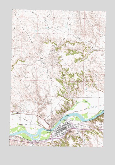
Forsyth, MT USGS Topographic Map
Click on map above to begin viewing in our Map Viewer.

This topographic map contains these locations and features:
Feature Name Type Latitude Longitude GNIS ID View Map
06N40E02DCCC01 WellWellN46.2967°W106.6848°815192View Map
06N40E13CD__01 WellWellN46.2681°W106.6681°814947View Map
06N40E15D___01 WellWellN46.2697°W106.7017°814957View Map
06N40E17A___01 WellWellN46.2769°W106.7431°815011View Map
06N40E20A___01 WellWellN46.2625°W106.7431°814898View Map
06N40E22DD__01 WellWellN46.2533°W106.6992°814815View Map
06N40E23ABAB01 WellWellN46.2661°W106.6809°814925View Map
06N40E23BA__01 WellWellN46.2642°W106.6886°814913View Map
06N40E23BAAD01 WellWellN46.2653°W106.6853°814921View Map
06N40E23CC__01 WellWellN46.2533°W106.6939°814814View Map
06N40E24BB__01 WellWellN46.2642°W106.6731°814912View Map
06N41E17C___01 WellWellN46.2703°W106.6289°814971View Map
Alexandria (historical)LocaleN46.2736°W106.6484°1716731View Map
Ascension Episcopal Church (historical)ChurchN46.2708°W106.6742°1716657View Map
Assembly of God ChurchChurchN46.2681°W106.6781°1716663View Map
Christian Science Society Church (historical)ChurchN46.2650°W106.6853°1716656View Map
Church of GodChurchN46.2689°W106.6728°1716661View Map
City of ForsythCivilN46.2669°W106.6749°2410523View Map
Cold Spring Ranch (historical)LocaleN46.2778°W106.7270°1716706View Map
Concordia Lutheran ChurchChurchN46.2675°W106.6806°1716660View Map
Cornerstone Grace FellowshipChurchN46.2708°W106.6548°1716653View Map
East Rosebud State ParkParkN46.2744°W106.6784°771107View Map
Federated ChurchChurchN46.2675°W106.6761°1716665View Map
First Baptist ChurchChurchN46.2706°W106.6709°1716662View Map
ForsythLocaleN46.2631°W106.6820°1716695View Map
ForsythPopulated PlaceN46.2664°W106.6778°771501View Map
Forsyth CemeteryCemeteryN46.2684°W106.6558°771502View Map
Forsyth Elementary SchoolSchoolN46.2710°W106.6675°1716574View Map
Forsyth Family MedicineHospitalN46.2717°W106.6703°1716669View Map
Forsyth High SchoolSchoolN46.2687°W106.6817°1716575View Map
Forsyth Middle SchoolSchoolN46.2714°W106.6678°1716573View Map
Forsyth Post OfficePost OfficeN46.2670°W106.6790°1716696View Map
Forsyth Volunteer Fire DepartmentBuildingN46.2670°W106.6801°1716525View Map
Forsyth Wesleyan ChurchChurchN46.2625°W106.6895°1716655View Map
Hammond ValleyValleyN46.2664°W106.7045°772111View Map
Immaculate Conception ChurchChurchN46.2703°W106.6778°1716659View Map
Interchange 93CrossingN46.2569°W106.6936°1716678View Map
Interchange 95CrossingN46.2667°W106.6656°1716677View Map
Jehovah's WitnessesChurchN46.2647°W106.6820°1716658View Map
KIKC-AM (Forsyth)TowerN46.2583°W106.6898°806615View Map
Lee Number 6 DamDamN46.3600°W106.7023°796876View Map
Marceys ParkParkN46.2694°W106.6800°1716523View Map
Marcys School (historical)SchoolN46.2528°W106.6942°1716576View Map
Mogen Number 1 DamDamN46.3033°W106.6389°796954View Map
Pioneer ParkParkN46.2683°W106.6739°1716528View Map
Porcupine (historical)Populated PlaceN46.2897°W106.6603°1716771View Map
Porcupine Post Office (historical)Post OfficeN46.2897°W106.6603°1716772View Map
Riverside ParkParkN46.2703°W106.6811°1716529View Map
Rosebud CampgroundLocaleN46.2633°W106.6950°1716666View Map
Rosebud CampgroundLocaleN46.2747°W106.6784°1716667View Map
Rosebud County Ambulance ServiceBuildingN46.2655°W106.6743°2637902View Map
Rosebud County CourthouseBuildingN46.2678°W106.6750°1716531View Map
Rosebud County FairgroundsLocaleN46.2739°W106.6714°1716532View Map
Rosebud County Fire DepartmentBuildingN46.2683°W106.6626°2546540View Map
Rosebud County LibraryBuildingN46.2664°W106.6803°1716672View Map
Rosebud County Pioneer MuseumBuildingN46.2681°W106.6739°1716671View Map
Rosebud County Sheriff's OfficeBuildingN46.2662°W106.6734°1716530View Map
Rosebud East Fishing Access SiteLocaleN46.2739°W106.6775°1744442View Map
Rosebud Health Care CenterHospitalN46.2718°W106.6705°1716670View Map
Rosebud West Fishing Access SiteLocaleN46.2630°W106.6956°1744444View Map
Short CreekStreamN46.2894°W106.6628°776510View Map
Slaughterhouse CreekStreamN46.2733°W106.6528°776633View Map
Smith CreekStreamN46.2555°W106.7170°776671View Map
The Church of Jesus Christ of Latter Day SaintsChurchN46.2792°W106.7186°1716654View Map
VFW ParkParkN46.2644°W106.6898°1721500View Map
Wagon Wheel CampgroundLocaleN46.2639°W106.6603°1716668View Map
West Rosebud State ParkParkN46.2633°W106.6950°778308View Map

Note: Coordinates in the location and feature list above are referenced to NAD83 datum.


Copyright (C) 2008-2025 Ryan Niemi / Sunset Dynamics ... All Rights Reserved