TopoQuest Logo
Do you find TopoQuest useful?
Help keep TopoQuest running and adding new maps/features by donating!
Bitcoin:  19c7KJd3qBynnjoSw5npx9KScwjBe4ifkT
Litecoin:  LXs6TkuXGGXo1vDsWCkWVdjQX94eUKd6ui
Home View Maps Find Maps Find Places Resources & Links


Fort Reno, Oklahoma Topographic Map

USGS Map Title: Fort Reno, OK
USGS Map MRC: 35098E1
DRG (GeoTIFF) Download: o35098e1.tif


Neighboring USGS Topographic Map Quads:


  Porcupine Butte, OK  
35098F2
 

  Fort Reno NE, OK  
35098F1
 

  Okarche, OK  
35097F8
 

  Fort Reno SW, OK  
35098E2
 

  Fort Reno, OK  
35098E1
 

  El Reno, OK  
35097E8
 

  Cogar NW, OK  
35098D2
 

  Cogar NE, OK  
35098D1
 

  Union City, OK  
35097D8


Map MRC Location:

N36°
W99°
N36°
W98°
H8 H7 H6 H5 H4 H3 H2 H1
G8 G7 G6 G5 G4 G3 G2 G1
F8 F7 F6 F5 F4 F3 F2 F1
E8 E7 E6 E5 E4 E3 E2 E1
D8 D7 D6 D5 D4 D3 D2 D1
C8 C7 C6 C5 C4 C3 C2 C1
B8 B7 B6 B5 B4 B3 B2 B1
A8 A7 A6 A5 A4 A3 A2 A1
N35°
W99°
N35°
W98°

Fort Reno, OK USGS 1:24K Topographic Map Preview:
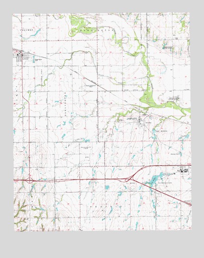
Fort Reno, OK USGS Topographic Map
Click on map above to begin viewing in our Map Viewer.

This topographic map contains these locations and features:
Feature Name Type Latitude Longitude GNIS ID View Map
CalumetPopulated PlaceN35.6012°W98.1187°1090810View Map
Calumet Elementary SchoolSchoolN35.6015°W98.1218°1790584View Map
Calumet High SchoolSchoolN35.6017°W98.1219°2713159View Map
Calumet Junior High SchoolSchoolN35.6014°W98.1208°1790280View Map
Calumet Police DepartmentBuildingN35.6001°W98.1194°2757791View Map
Calumet Volunteer Fire DepartmentBuildingN35.6007°W98.1184°2658283View Map
Cheyenne and Arapaho Agency (historical)Populated PlaceN35.5722°W98.0197°2438092View Map
Darlington State Game Bird HatcheryLocaleN35.5742°W98.0128°1102005View Map
El Reno Federal ReformatoryLocaleN35.5348°W98.0073°1102009View Map
Federal Correctional Institution El RenoBuildingN35.5343°W98.0056°2757933View Map
Fort Reno Post CemeteryCemeteryN35.5634°W98.0478°1092966View Map
Halfway PondReservoirN35.5437°W98.0075°1093487View Map
Harman AirportAirportN35.5836°W98.0450°1102389View Map
Lake RollaReservoirN35.5286°W98.0271°1097401View Map
Long PondReservoirN35.5537°W98.0030°1094966View Map
Oknoname 017002 DamDamN35.5567°W98.0537°1752409View Map
Oknoname 017002 ReservoirReservoirN35.5567°W98.0537°1752410View Map
Pellar Farm AirportAirportN35.5070°W98.0408°1102457View Map
Prisoner of War CemeteryCemeteryN35.5635°W98.0482°2704699View Map
Sixmile CreekStreamN35.5875°W98.0295°1098080View Map
Southwestern Livestock and Forage Research StationLocaleN35.5623°W98.0367°1092965View Map
Target CreekStreamN35.5698°W98.0056°1098757View Map
Town of CalumetCivilN35.6014°W98.1246°2413150View Map
Township of DarlingtonCivilN35.6028°W98.0587°1825546View Map

Note: Coordinates in the location and feature list above are referenced to NAD83 datum.


Copyright (C) 2008-2024 Ryan Niemi / Sunset Dynamics ... All Rights Reserved