TopoQuest Logo
Do you find TopoQuest useful?
Help keep TopoQuest running and adding new maps/features by donating!
Bitcoin:  19c7KJd3qBynnjoSw5npx9KScwjBe4ifkT
Litecoin:  LXs6TkuXGGXo1vDsWCkWVdjQX94eUKd6ui
Home View Maps Find Maps Find Places Resources & Links


Fort Stockton West, Texas Topographic Map

USGS Map Title: Fort Stockton West, TX
USGS Map MRC: 30102H8
DRG (GeoTIFF) Download: o30102h8.tif


Neighboring USGS Topographic Map Quads:


  Coyanosa SE, TX  
31103A1
 

  Diamond Y Spring, TX  
31102A8
 

  Diamond Y Spring SE, TX  
31102A7
 

  Belding NE, TX  
30103H1
 

  Fort Stockton West, TX  
30102H8
 

  Fort Stockton East, TX  
30102H7
 

  Belding, TX  
30103G1
 

  Twelvemile Mesa, TX  
30102G8
 

  Fivemile Mesa, TX  
30102G7


Map MRC Location:

N31°
W103°
N31°
W102°
H8 H7 H6 H5 H4 H3 H2 H1
G8 G7 G6 G5 G4 G3 G2 G1
F8 F7 F6 F5 F4 F3 F2 F1
E8 E7 E6 E5 E4 E3 E2 E1
D8 D7 D6 D5 D4 D3 D2 D1
C8 C7 C6 C5 C4 C3 C2 C1
B8 B7 B6 B5 B4 B3 B2 B1
A8 A7 A6 A5 A4 A3 A2 A1
N30°
W103°
N30°
W102°

Fort Stockton West, TX USGS 1:24K Topographic Map Preview:
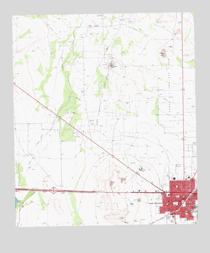
Fort Stockton West, TX USGS Topographic Map
Click on map above to begin viewing in our Map Viewer.

This topographic map contains these locations and features:
Feature Name Type Latitude Longitude GNIS ID View Map
Alamo Elementary SchoolSchoolN30.8807°W102.8915°2008173View Map
Alamo SchoolSchoolN30.8799°W102.8921°1350934View Map
Annie Riggs MuseumBuildingN30.8840°W102.8790°2014525View Map
Apache Elementary SchoolSchoolN30.9021°W102.8807°2008174View Map
Apache SchoolSchoolN30.9027°W102.8810°1351218View Map
Butz Education CenterSchoolN30.8827°W102.8829°2008111View Map
Butz SchoolSchoolN30.8821°W102.8829°1353439View Map
City of Fort StocktonCivilN30.8926°W102.8847°2410530View Map
Comanche Elementary SchoolSchoolN30.8921°W102.8949°2008112View Map
Comanche SchoolSchoolN30.8927°W102.8952°1354834View Map
Comanche SpringsSpringN30.8815°W102.8788°1354837View Map
Comanche Springs (historical)SpringN30.8918°W102.8757°2025145View Map
Faith Lutheran ChurchChurchN30.8910°W102.8946°2023754View Map
First Baptist ChurchChurchN30.8824°W102.8877°2023812View Map
First Presbyterian ChurchChurchN30.8865°W102.8888°2023756View Map
Flat TopSummitN30.9757°W102.8965°1357451View Map
Fort StocktonPopulated PlaceN30.8940°W102.8793°1357597View Map
Fort Stockton City HallBuildingN30.8862°W102.8795°2753198View Map
Fort Stockton City ParkParkN30.8971°W102.8882°2028315View Map
Fort Stockton High SchoolSchoolN30.9010°W102.8915°2008113View Map
Fort Stockton Intermediate SchoolSchoolN30.8865°W102.8904°2008114View Map
Fort Stockton Middle SchoolSchoolN30.8893°W102.9043°2008071View Map
Fort Stockton Oil and Gas FieldOilfieldN30.9346°W102.9565°1357598View Map
Fort Stockton Police DepartmentBuildingN30.8862°W102.8795°2750305View Map
Fort Stockton Post OfficePost OfficeN30.8880°W102.8785°2731705View Map
Fort Stockton Volunteer Fire Department Northside StationBuildingN30.8982°W102.8892°2551201View Map
Fort Stockton Volunteer Fire Department Southside StationBuildingN30.8866°W102.8801°2551976View Map
Fort Stockton-Pecos County AirportAirportN30.9094°W102.9130°1384791View Map
Gibbs Field (historical)MilitaryN30.9139°W102.9086°2105527View Map
Gomez Oil and Gas FieldOilfieldN30.9599°W102.8927°1358140View Map
GuildPopulated PlaceN30.9560°W102.8754°1379870View Map
Highline DitchCanalN30.9265°W102.8868°1359218View Map
Hood Mendel ArenaBuildingN30.8877°W102.8754°1359517View Map
James Rooney Memorial ParkParkN30.8843°W102.8754°1360146View Map
KFST-AM (Fort Stockton)TowerN30.8771°W102.8921°1385558View Map
KFST-FM (Fort Stockton)TowerN30.8771°W102.8921°1385853View Map
Lannom ParkParkN30.8915°W102.8882°1360948View Map
Little Mexico ColoniaPopulated PlaceN30.9182°W102.8785°2011344View Map
Northside Baptist ChurchChurchN30.8999°W102.8868°2023752View Map
Old Fort CemeteryCemeteryN30.8921°W102.8782°1364420View Map
Panther StadiumParkN30.9010°W102.8915°2027722View Map
Pat Taylor Athletic FieldParkN30.8788°W102.8949°1364866View Map
Pecos County CourthouseBuildingN30.8835°W102.8796°2030569View Map
Pecos County Emergency Medical ServicesBuildingN30.8894°W102.8821°2656124View Map
Pecos County Memorial HospitalHospitalN30.9056°W102.8802°2718161View Map
Pecos County Sheriff's OfficeBuildingN30.9081°W102.9193°2750554View Map
Pecos County Sheriff's OfficeBuildingN30.8818°W102.8800°2750331View Map
Saint Joseph Baptist ChurchChurchN30.8824°W102.8790°2023753View Map
Sevenmile MesaSummitN30.9279°W102.8754°1367988View Map
Texas Department of Public Safety Highway Patrol OfficeBuildingN30.8945°W102.9053°2750676View Map
Texas Forest Service Fort Stockton OfficeBuildingN30.8930°W102.9148°2551282View Map
The Church of Jesus Christ of Latter Day SaintsChurchN30.9024°W102.9018°2023755View Map
The Needle PointSummitN30.9696°W102.9335°1369801View Map
Twomile HillSummitN30.8879°W102.9327°1370406View Map
United States Border Patrol StationBuildingN30.9021°W102.8848°2750832View Map

Note: Coordinates in the location and feature list above are referenced to NAD83 datum.


Copyright (C) 2008-2025 Ryan Niemi / Sunset Dynamics ... All Rights Reserved