TopoQuest Logo
Do you find TopoQuest useful?
Help keep TopoQuest running and adding new maps/features by donating!
Bitcoin:  19c7KJd3qBynnjoSw5npx9KScwjBe4ifkT
Litecoin:  LXs6TkuXGGXo1vDsWCkWVdjQX94eUKd6ui
Home View Maps Find Maps Find Places Resources & Links


Fouke NE, Arkansas Topographic Map

USGS Map Title: Fouke NE, AR
USGS Map MRC: 33093D7
DRG (GeoTIFF) Download: o33093d7.tif


Neighboring USGS Topographic Map Quads:


  Homan, AR  
33093E8
 

  Fulton, AR  
33093E7
 

  Spring Hill, AR  
33093E6
 

  Mandeville, AR  
33093D8
 

  Fouke NE, AR  
33093D7
 

  Boyd Hill, AR  
33093D6
 

  Fouke, AR  
33093C8
 

  Fouke SE, AR  
33093C7
 

  Garland, AR  
33093C6


Map MRC Location:

N34°
W94°
N34°
W93°
H8 H7 H6 H5 H4 H3 H2 H1
G8 G7 G6 G5 G4 G3 G2 G1
F8 F7 F6 F5 F4 F3 F2 F1
E8 E7 E6 E5 E4 E3 E2 E1
D8 D7 D6 D5 D4 D3 D2 D1
C8 C7 C6 C5 C4 C3 C2 C1
B8 B7 B6 B5 B4 B3 B2 B1
A8 A7 A6 A5 A4 A3 A2 A1
N33°
W94°
N33°
W93°

Fouke NE, AR USGS 1:24K Topographic Map Preview:
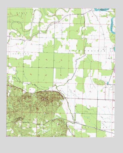
Fouke NE, AR USGS Topographic Map
Click on map above to begin viewing in our Map Viewer.

This topographic map contains these locations and features:
Feature Name Type Latitude Longitude GNIS ID View Map
ArtexPopulated PlaceN33.3876°W93.8321°76200View Map
Coe CreekStreamN33.4323°W93.8721°47882View Map
DooleyPopulated PlaceN33.4687°W93.8574°56994View Map
First Old River LakeLakeN33.4987°W93.7678°74826View Map
Garland City Oil and Gas FieldOilfieldN33.3996°W93.7835°63095View Map
HerveyPopulated PlaceN33.4982°W93.7771°57057View Map
Krause HillSummitN33.4112°W93.8302°50914View Map
McKinneyPopulated PlaceN33.3890°W93.7955°57110View Map
Mill CreekStreamN33.4287°W93.8616°52005View Map
Red ChuteStreamN33.4229°W93.8171°53940View Map
Rock Springs CemeteryCemeteryN33.3979°W93.8307°54112View Map
Second Old River LakeLakeN33.4766°W93.7521°75120View Map
The MoundsSummitN33.4290°W93.7618°63112View Map
Township of Lost Prairie (historical)CivilN33.4598°W93.7835°63131View Map
Township of Red RiverCivilN33.3907°W93.7531°68865View Map
Tregg ChurchChurchN33.4696°W93.8494°55643View Map
Troy ChurchChurchN33.4112°W93.8107°55664View Map
Wolf MountainSummitN33.3932°W93.8591°56497View Map

Note: Coordinates in the location and feature list above are referenced to NAD83 datum.


Copyright (C) 2008-2024 Ryan Niemi / Sunset Dynamics ... All Rights Reserved