TopoQuest Logo
Do you find TopoQuest useful?
Help keep TopoQuest running and adding new maps/features by donating!
Bitcoin:  19c7KJd3qBynnjoSw5npx9KScwjBe4ifkT
Litecoin:  LXs6TkuXGGXo1vDsWCkWVdjQX94eUKd6ui
Home View Maps Find Maps Find Places Resources & Links


Fowlstown, Georgia Topographic Map

USGS Map Title: Fowlstown, GA
USGS Map MRC: 30084G5
DRG (GeoTIFF) Download: o30084g5.tif


Neighboring USGS Topographic Map Quads:


  Brinson, GA  
30084H6
 

  Bainbridge, GA  
30084H5
 

  Climax North, GA  
30084H4
 

  Faceville, GA  
30084G6
 

  Fowlstown, GA  
30084G5
 

  Climax South, GA  
30084G4
 

  Mount Pleasant, FL  
30084F6
 

  Dogtown, FL  
30084F5
 

  Havana North, FL  
30084F4


Map MRC Location:

N31°
W85°
N31°
W84°
H8 H7 H6 H5 H4 H3 H2 H1
G8 G7 G6 G5 G4 G3 G2 G1
F8 F7 F6 F5 F4 F3 F2 F1
E8 E7 E6 E5 E4 E3 E2 E1
D8 D7 D6 D5 D4 D3 D2 D1
C8 C7 C6 C5 C4 C3 C2 C1
B8 B7 B6 B5 B4 B3 B2 B1
A8 A7 A6 A5 A4 A3 A2 A1
N30°
W85°
N30°
W84°

Fowlstown, GA USGS 1:24K Topographic Map Preview:
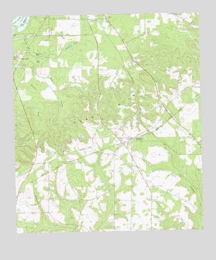
Fowlstown, GA USGS Topographic Map
Click on map above to begin viewing in our Map Viewer.

This topographic map contains these locations and features:
Feature Name Type Latitude Longitude GNIS ID View Map
Antioch ChurchChurchN30.8366°W84.5146°310559View Map
Antioch ChurchChurchN30.8749°W84.5174°310560View Map
Ballou CreekStreamN30.8396°W84.6044°310765View Map
Christ Memorial ChurchChurchN30.8521°W84.6185°344537View Map
Davis LakeReservoirN30.8398°W84.5295°338378View Map
Davis Lake DamDamN30.8419°W84.5316°338377View Map
Decatur County Fire and Rescue Station 245BuildingN30.7985°W84.5510°2604172View Map
Decatur County Fire and Rescue Station 270BuildingN30.8545°W84.6200°2604023View Map
Duck PondLakeN30.8488°W84.6099°313700View Map
Emanuel ChurchChurchN30.7905°W84.5905°355685View Map
Fountain PondLakeN30.8530°W84.6099°314312View Map
Fourmile CreekStreamN30.8641°W84.6180°314317View Map
FowlstownPopulated PlaceN30.8027°W84.5471°355902View Map
Fowlstown Post OfficePost OfficeN30.8032°W84.5485°352235View Map
Fowlstown SwampSwampN30.8582°W84.5846°314330View Map
Ginhouse CreekStreamN30.8432°W84.6105°314626View Map
Green Shade CemeteryCemeteryN30.7966°W84.5882°314854View Map
John the Baptist ChurchChurchN30.8505°W84.6194°316137View Map
Mount Nebo ChurchChurchN30.8744°W84.5152°318705View Map
Parramore CreekStreamN30.8510°W84.6085°320246View Map
Peterson CemeteryCemeteryN30.7530°W84.6163°320413View Map
Rich LakeReservoirN30.7936°W84.5396°341992View Map
Rich Lake DamDamN30.7919°W84.5382°341991View Map
Saint Joseph Church (historical)ChurchN30.8110°W84.5685°344598View Map
Saint Paul ChurchChurchN30.8035°W84.5552°344601View Map
Spring CreekStreamN30.8555°W84.5844°323373View Map

Note: Coordinates in the location and feature list above are referenced to NAD83 datum.


Copyright (C) 2008-2024 Ryan Niemi / Sunset Dynamics ... All Rights Reserved