TopoQuest Logo
Do you find TopoQuest useful?
Help keep TopoQuest running and adding new maps/features by donating!
Bitcoin:  19c7KJd3qBynnjoSw5npx9KScwjBe4ifkT
Litecoin:  LXs6TkuXGGXo1vDsWCkWVdjQX94eUKd6ui
Home View Maps Find Maps Find Places Resources & Links


Frazer, Montana Topographic Map

USGS Map Title: Frazer, MT
USGS Map MRC: 48106A1
DRG (GeoTIFF) Download: o48106a1.tif


Neighboring USGS Topographic Map Quads:


  Milk River Coulee, MT  
48106B2
 

  Dubbe Reservoir, MT  
48106B1
 

  Oswego NW, MT  
48105B8
 

  Kintyre, MT  
48106A2
 

  Frazer, MT  
48106A1
 

  Oswego, MT  
48105A8
 

  McRae Springs, MT  
47106H2
 

  Pasture Creek, MT  
47106H1
 

  Turtle Creek, MT  
47105H8


Map MRC Location:

N49°
W107°
N49°
W106°
H8 H7 H6 H5 H4 H3 H2 H1
G8 G7 G6 G5 G4 G3 G2 G1
F8 F7 F6 F5 F4 F3 F2 F1
E8 E7 E6 E5 E4 E3 E2 E1
D8 D7 D6 D5 D4 D3 D2 D1
C8 C7 C6 C5 C4 C3 C2 C1
B8 B7 B6 B5 B4 B3 B2 B1
A8 A7 A6 A5 A4 A3 A2 A1
N48°
W107°
N48°
W106°

Frazer, MT USGS 1:24K Topographic Map Preview:
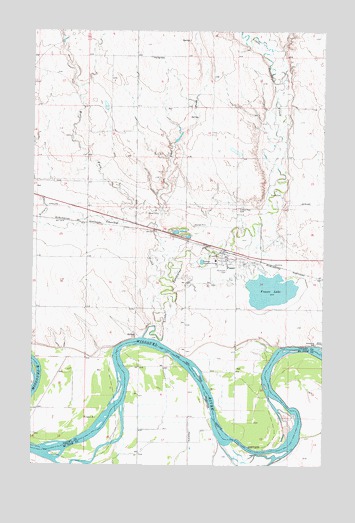
Frazer, MT USGS Topographic Map
Click on map above to begin viewing in our Map Viewer.

This topographic map contains these locations and features:
Feature Name Type Latitude Longitude GNIS ID View Map
26N43E12DD__01 WellWellN48.0186°W106.1050°825566View Map
26N43E24AA__01 WellWellN48.0003°W106.1050°825440View Map
26N44E05CC__01 WellWellN48.0303°W106.0789°825658View Map
26N44E05DD__01 WellWellN48.0303°W106.0628°825657View Map
26N44E07AA__01 WellWellN48.0267°W106.0842°825629View Map
26N44E07AD__01 WellWellN48.0231°W106.0842°825597View Map
26N44E07AD__02 WellWellN48.0231°W106.0842°825598View Map
26N44E07BA__01 WellWellN48.0267°W106.0950°825630View Map
26N44E07DA__01 WellWellN48.0195°W106.0842°825570View Map
26N44E07DA__02 WellWellN48.0195°W106.0842°825571View Map
26N44E07DD__01 WellWellN48.0159°W106.0842°825551View Map
26N44E08AA__01 WellWellN48.0267°W106.0628°825625View Map
26N44E08AB__01 WellWellN48.0267°W106.0681°825626View Map
26N44E08AC__01 WellWellN48.0231°W106.0681°825595View Map
26N44E08AC__02 WellWellN48.0231°W106.0681°825596View Map
26N44E08BA__01 WellWellN48.0267°W106.0734°825627View Map
26N44E08BA__02 WellWellN48.0267°W106.0734°825628View Map
26N44E08CB__01 WellWellN48.0195°W106.0789°825569View Map
26N44E08DD__01 WellWellN48.0159°W106.0628°825550View Map
26N44E09AC__01 WellWellN48.0231°W106.0464°825593View Map
26N44E09BC__01 WellWellN48.0231°W106.0572°825594View Map
26N44E09CB__01 WellWellN48.0195°W106.0572°825568View Map
26N44E09CC__01 WellWellN48.0159°W106.0572°825549View Map
26N44E10BC__01 WellWellN48.0231°W106.0356°825592View Map
26N44E11BB__01 WellWellN48.0267°W106.0139°825624View Map
26N44E11CD__01 WellWellN48.0159°W106.0086°825548View Map
26N44E14CC__01 WellWellN48.0014°W106.0139°825445View Map
26N44E15BB__01 WellWellN48.0122°W106.0356°825521View Map
26N44E15BC__01 WellWellN48.0086°W106.0356°825488View Map
26N44E16BC__01 WellWellN48.0086°W106.0572°825489View Map
26N44E16CA__01 WellWellN48.0050°W106.0520°825469View Map
26N44E16CC__01 WellWellN48.0014°W106.0572°825446View Map
26N44E16CC__02 WellWellN48.0014°W106.0572°825447View Map
26N44E17AA__01 WellWellN48.0122°W106.0628°825522View Map
26N44E17AA__02 WellWellN48.0122°W106.0628°825523View Map
26N44E17AA__03 WellWellN48.0122°W106.0628°825524View Map
26N44E17AB__01 WellWellN48.0122°W106.0681°825525View Map
26N44E17BD__01 WellWellN48.0086°W106.0734°825490View Map
26N44E17CB__01 WellWellN48.0050°W106.0789°825471View Map
26N44E17CC__01 WellWellN48.0014°W106.0789°825451View Map
26N44E17CD__01 WellWellN48.0014°W106.0734°825450View Map
26N44E17DB__01 WellWellN48.0050°W106.0681°825470View Map
26N44E17DC__01 WellWellN48.0014°W106.0681°825448View Map
26N44E17DC__02 WellWellN48.0014°W106.0681°825449View Map
26N44E18AA__01 WellWellN48.0122°W106.0842°825526View Map
26N44E18AC__03 WellWellN48.0086°W106.0897°825493View Map
26N44E18AD__01 WellWellN48.0086°W106.0842°825491View Map
26N44E18AD__02 WellWellN48.0086°W106.0842°825492View Map
26N44E18CD__01 WellWellN48.0014°W106.0950°825453View Map
26N44E18DA__01 WellWellN48.0050°W106.0842°825472View Map
26N44E18DC__01 WellWellN48.0014°W106.0897°825452View Map
27N43E25AD__01 WellWellN48.0703°W106.1047°825994View Map
27N44E26CB__01 WellWellN48.0650°W106.0134°825939View Map
27N44E27BC__01 WellWellN48.0686°W106.0350°825974View Map
27N44E27BCCA01 WellWellN48.0686°W106.0359°825975View Map
27N44E28CC__01 WellWellN48.0614°W106.0567°825915View Map
27N44E28DC__01 WellWellN48.0614°W106.0459°825914View Map
27N44E28DD__01 WellWellN48.0614°W106.0406°825913View Map
27N44E31AA__01 WellWellN48.0578°W106.0836°825881View Map
27N44E32CA__01 WellWellN48.0506°W106.0728°825830View Map
27N44E32DC__01 WellWellN48.0470°W106.0675°825805View Map
27N44E33AC__01 WellWellN48.0542°W106.0459°825861View Map
27N44E33AD__01 WellWellN48.0542°W106.0406°825860View Map
27N44E33BC__01 WellWellN48.0542°W106.0567°825862View Map
27N44E34AC__01 WellWellN48.0542°W106.0242°825859View Map
27N44E34ACAB01 WellWellN48.0553°W106.0239°825867View Map
Big Sky Indian ChapelChurchN48.0592°W106.0422°1677293View Map
Blackmon Post Office (historical)Post OfficeN48.0003°W106.0234°1716158View Map
Charley CreekStreamN48.0520°W106.0700°769765View Map
Dakota Presbyterian ChurchChurchN48.0592°W106.0422°1677294View Map
East Fork Charley CreekStreamN48.0692°W106.0728°771027View Map
Equity Cooperative Elevator (historical)LocaleN48.0611°W106.0422°1688599View Map
FrazerLocaleN48.0614°W106.0420°1688540View Map
FrazerPopulated PlaceN48.0592°W106.0422°771614View Map
Frazer Census Designated PlaceCensusN48.0532°W106.0482°2408256View Map
Frazer LakeReservoirN48.0504°W106.0232°771615View Map
Frazer Lake Dam EastDamN48.0500°W106.0139°798225View Map
Frazer Post OfficePost OfficeN48.0605°W106.0437°1688539View Map
Frazer SchoolSchoolN48.0592°W106.0467°1819578View Map
Frazer Volunteer Fire CompanyBuildingN48.0601°W106.0396°2546638View Map
Government Day School (historical)SchoolN48.0528°W106.0495°1819509View Map
Hungry CreekStreamN48.0008°W106.1075°772617View Map
In Memoriam Historical MarkerParkN48.0611°W106.0311°1813130View Map
Inperial Elevator (historical)LocaleN48.0611°W106.0422°1688598View Map
Kintyre CreekStreamN48.0697°W106.1231°773072View Map
Lenox (historical)LocaleN48.0586°W106.0267°1688513View Map
Little Porcupine CreekStreamN48.0370°W106.0775°773476View Map
Little Porcupine DamDamN48.0534°W106.0339°795672View Map
Saint Joseph CemeteryCemeteryN48.0561°W106.0420°776113View Map
Saint Josephs Catholic ChurchChurchN48.0578°W106.0500°1677295View Map
Saint Pauls Evangelical Lutheran Church (historical)ChurchN48.0592°W106.0422°1677296View Map
Smith-Tyner Elevator (historical)LocaleN48.0611°W106.0422°1688594View Map
Sunset Rest CemeteryCemeteryN48.0738°W106.0374°777340View Map
West Fork Charley CreekStreamN48.0689°W106.0764°778232View Map

Note: Coordinates in the location and feature list above are referenced to NAD83 datum.


Copyright (C) 2008-2025 Ryan Niemi / Sunset Dynamics ... All Rights Reserved