TopoQuest Logo
Do you find TopoQuest useful?
Help keep TopoQuest running and adding new maps/features by donating!
Bitcoin:  19c7KJd3qBynnjoSw5npx9KScwjBe4ifkT
Litecoin:  LXs6TkuXGGXo1vDsWCkWVdjQX94eUKd6ui
Home View Maps Find Maps Find Places Resources & Links


Fredericksburg West, Texas Topographic Map

USGS Map Title: Fredericksburg West, TX
USGS Map MRC: 30098C8
DRG (GeoTIFF) Download: o30098c8.tif


Neighboring USGS Topographic Map Quads:


  Cherry Spring, TX  
30099D1
 

  Cherry Mountain, TX  
30098D8
 

  Crabapple, TX  
30098D7
 

  Roundhead, TX  
30099C1
 

  Fredericksburg West, TX  
30098C8
 

  Fredericksburg East, TX  
30098C7
 

  Morris Ranch, TX  
30099B1
 

  Lady Bird Johnson Park, TX  
30098B8
 

  Cain City, TX  
30098B7


Map MRC Location:

N31°
W99°
N31°
W98°
H8 H7 H6 H5 H4 H3 H2 H1
G8 G7 G6 G5 G4 G3 G2 G1
F8 F7 F6 F5 F4 F3 F2 F1
E8 E7 E6 E5 E4 E3 E2 E1
D8 D7 D6 D5 D4 D3 D2 D1
C8 C7 C6 C5 C4 C3 C2 C1
B8 B7 B6 B5 B4 B3 B2 B1
A8 A7 A6 A5 A4 A3 A2 A1
N30°
W99°
N30°
W98°

Fredericksburg West, TX USGS 1:24K Topographic Map Preview:
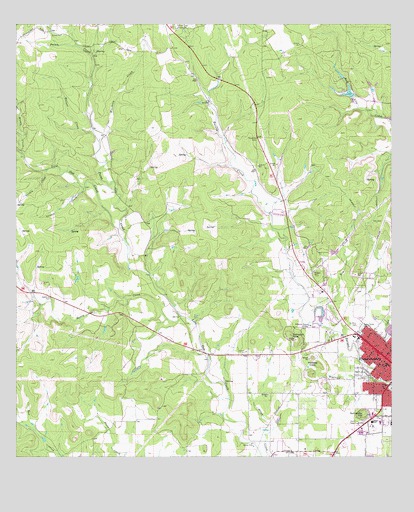
Fredericksburg West, TX USGS Topographic Map
Click on map above to begin viewing in our Map Viewer.

This topographic map contains these locations and features:
Feature Name Type Latitude Longitude GNIS ID View Map
Carter Ranch AirportAirportN30.3211°W98.9147°1386688View Map
Cisco Public LibraryBuildingN30.3535°W98.9831°2014989View Map
City of FredericksburgCivilN30.2671°W98.8756°2410542View Map
Douglass LakeReservoirN30.3552°W98.8895°1859278View Map
Douglass Lake DamDamN30.3552°W98.8887°1859277View Map
Dry CreekStreamN30.2852°W98.8909°1334660View Map
Fredericksburg Alternative SchoolSchoolN30.2794°W98.8803°2005612View Map
Fredericksburg DivisionCivilN30.3264°W98.9365°1938756View Map
Fredericksburg High SchoolSchoolN30.2613°W98.8823°2005614View Map
Fredericksburg Historic DistrictLocaleN30.2846°W98.8803°2032103View Map
Fredericksburg Learning CenterSchoolN30.2621°W98.8787°2005615View Map
Fredericksburg Post OfficePost OfficeN30.2862°W98.8866°2731810View Map
Garden CreekStreamN30.3280°W98.9773°1336390View Map
Gillespie CountyCivilN30.3181°W98.9465°1383871View Map
Gillespie County Historical SocietyBuildingN30.2777°W98.8759°2014119View Map
Guenther SpringSpringN30.2752°W98.9420°1998559View Map
Hill Country Memorial HospitalHospitalN30.2626°W98.8816°2718183View Map
Honey CreekStreamN30.2910°W98.9445°1338017View Map
Hotopp HillsSummitN30.2769°W98.8995°1338150View Map
KNAF-AM (Fredericksburg)TowerN30.2869°W98.8831°1385565View Map
Linden CreekStreamN30.3333°W98.9895°1339964View Map
Middle CreekStreamN30.3380°W98.9981°1341481View Map
Moccasin CreekStreamN30.3413°W98.9720°1341780View Map
Pecan CreekStreamN30.3085°W98.9623°1343767View Map
Saint Barnabas Episcopal ChurchChurchN30.2791°W98.8828°2018620View Map
Saint Mary CemeteryCemeteryN30.2885°W98.8859°1346016View Map
Saint Mary SchoolSchoolN30.2766°W98.8770°1346028View Map
Saint Marys Catholic ChurchChurchN30.2771°W98.8767°2032191View Map
Saint Marys Catholic Church Youth MinistryChurchN30.2769°W98.8767°2018618View Map
Schlaudt HillsSummitN30.2855°W98.9089°1346768View Map
Schneider HillSummitN30.2627°W98.8845°1346772View Map
Schugh CemeteryCemeteryN30.3744°W98.9456°1346793View Map
Seventh Day Adventist ChurchChurchN30.2621°W98.8784°2018623View Map
Town CreekStreamN30.2813°W98.8753°1348681View Map
Walnut CreekStreamN30.3444°W98.9739°1349419View Map
Winfried CreekStreamN30.2721°W98.8789°1350417View Map
Zion Lutheran ChurchChurchN30.2802°W98.8764°2018621View Map

Note: Coordinates in the location and feature list above are referenced to NAD83 datum.


Copyright (C) 2008-2025 Ryan Niemi / Sunset Dynamics ... All Rights Reserved